
Fitxer:1845 trailmap.png

Mida d'aquesta previsualització: 800 × 475 píxels. Altres resolucions: 320 × 190 píxels | 640 × 380 píxels | 993 × 589 píxels.
Fitxer original (993 × 589 píxels, mida del fitxer: 37 Ko, tipus MIME: image/png)
| Aquest fitxer i la informació mostrada a continuació provenen del dipòsit multimèdia lliure Wikimedia Commons. |
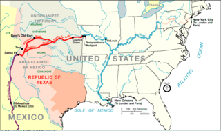
| Descripció | Santa Fe Trail around 1845 plus connecting trading routes to commercial hubs and ports in the USA | |||
| Font | http://www.nps.gov/beol/trailmap.gif | |||
| Autor | NPS-graphics | |||
| Permís (Com reutilitzar aquest fitxer) |
|
Registre original de càrregues
| Data/hora | Dimensions | Usuari/a | Comentari |
|---|---|---|---|
| 26 de juliol de 2006, 11:15:24 | 993 × 589 (44064 bytes) | H-stt (discussió · contribucions) | {{Information |Description= Santa Fe Trail around 1845 plus connecting trading routes to ports in the USA |Source= http://www.nps.gov/beol/trailmap.gif |Date= |Author= NPS-graphics |Permission= {{PD-USGov-NPS}} |other_versions= }} [[Category:Santa Fe Nat |
Historial del fitxer
Cliqueu una data/hora per veure el fitxer tal com era aleshores.
| Data/hora | Miniatura | Dimensions | Usuari/a | Comentari | |
|---|---|---|---|---|---|
| actual | 18:42, 12 jul 2014 | | 993 × 589 (37 Ko) | GifTagger | Bot: Converting file to superior PNG file. (Source: 1845_trailmap.gif). This GIF was problematic due to non-greyscale color table. |
Ús del fitxer
Les 2 pàgines següents utilitzen aquest fitxer:
Ús global del fitxer
Utilització d'aquest fitxer en altres wikis:
- Utilització a de.wikipedia.org
- Utilització a en.wikipedia.org
- Utilització a es.wikipedia.org
- Utilització a fa.wikipedia.org
- Utilització a fi.wikipedia.org
- Utilització a fr.wikipedia.org
- Utilització a hu.wikipedia.org
- Utilització a it.wikipedia.org
- Utilització a ja.wikipedia.org
- Utilització a nl.wikipedia.org
- Utilització a pl.wikipedia.org
- Utilització a ru.wikipedia.org
- Utilització a www.wikidata.org