
Fitxer:Adriatic Plate.jpg
Mida d'aquesta previsualització: 626 × 600 píxels. Altres resolucions: 250 × 240 píxels | 501 × 480 píxels | 817 × 783 píxels.
Fitxer original (817 × 783 píxels, mida del fitxer: 181 Ko, tipus MIME: image/jpeg)
| Aquest fitxer i la informació mostrada a continuació provenen del dipòsit multimèdia lliure Wikimedia Commons. |
Resum
| Descripció |
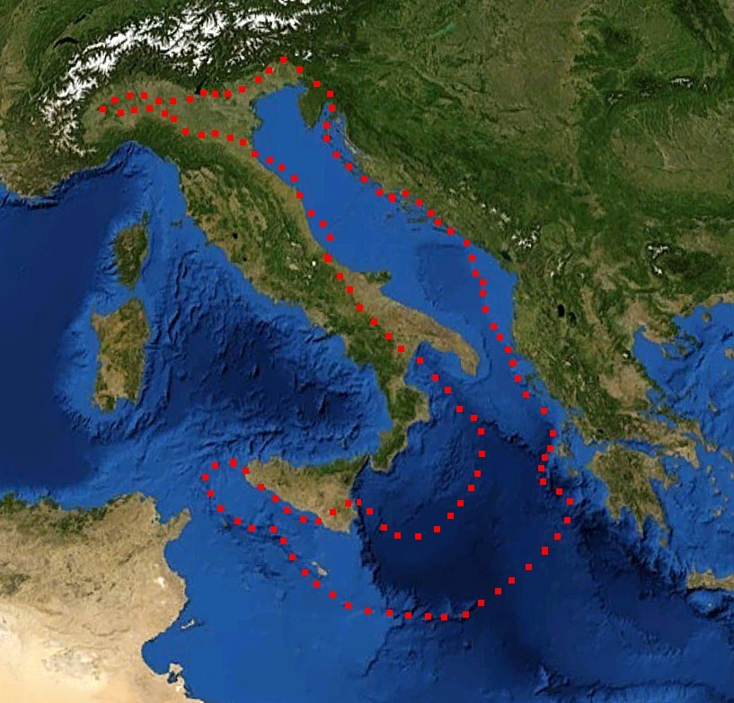
English: boundaries of the Adriatic plate
עברית: גבולות הלוח האדריאטי |
| Data | (UTC) |
| Font |
Mediterranian_Sea_16.61811E_38.99124N.jpg (July 2012). "Present kinematics of Central and Northern Italy from continuous GPS measurements". Journal of Geodynamics 58: 62-72. Elsevier. ISSN 0264-3707. Retrieved on 12 March 2012. plate boundary map preview |
| Autor |
|
| Això és una imatge retocada, cosa que vol dir que ha estat alterada digitalment de la seva versió original. Modificacions: crop, plate boundaries. L'original es pot veure a: Mediterranian Sea 16.61811E 38.99124N.jpg:
|
Llicència
| This image is in the public domain because it is a screenshot from NASA’s globe software World Wind using a public domain layer, such as Blue Marble, MODIS, Landsat, SRTM, USGS or GLOBE.
|
 |
| This work was previously under Public Domain, or a Free License. It has been digitally enhanced and/or modified. This derivative work has been (or is hereby) released into the public domain by its author, [[:{{{1}}}:User:{{{3}}}|{{{3}}}]] at the [[:{{{1}}}:|{{{2}}}]] project. This applies worldwide. In some countries this is not legally possible; if so:
|
Registre original de càrregues
This image is a derivative work of the following images:
- File:Mediterranian_Sea_16.61811E_38.99124N.jpg licensed with PD-WorldWind, PD-retouched-user-w
Uploaded with derivativeFX
Historial del fitxer
Cliqueu una data/hora per veure el fitxer tal com era aleshores.
| Data/hora | Miniatura | Dimensions | Usuari/a | Comentari | |
|---|---|---|---|---|---|
| actual | 19:52, 29 des 2011 | | 817 × 783 (181 Ko) | דקי | == {{int:filedesc}} == {{Information |Description={{en|boundaries of the Adriatic plate}} {{he|גבולות הלוח האדריאטי}} |Source=*File:Mediterranian_Sea_16.61811E_38.99124N.jpg |Date=2011-12-29 17:47 (UTC) |Author=*[[:File:Mediterrani |
Ús del fitxer
La pàgina següent utilitza aquest fitxer:
Ús global del fitxer
Utilització d'aquest fitxer en altres wikis:
- Utilització a az.wikipedia.org
- Utilització a bg.wikipedia.org
- Utilització a bn.wikipedia.org
- Utilització a cs.wikipedia.org
- Utilització a de.wikipedia.org
- Utilització a el.wikipedia.org
- Utilització a en.wikipedia.org
- Utilització a es.wikipedia.org
- Utilització a fa.wikipedia.org
- Utilització a fr.wikipedia.org
- Utilització a he.wikipedia.org
- Utilització a hr.wikipedia.org
- Utilització a hu.wikipedia.org
- Utilització a it.wikipedia.org
- Utilització a ja.wikipedia.org
- Utilització a nl.wikipedia.org
- Utilització a pl.wikipedia.org
- Utilització a pt.wikipedia.org
- Utilització a ru.wikipedia.org
- Utilització a sh.wikipedia.org
- Utilització a sl.wikipedia.org
- Utilització a sv.wikipedia.org
- Utilització a tr.wikipedia.org
- Utilització a uk.wikipedia.org
- Utilització a zh.wikipedia.org