
Fitxer:Anambra lga map.gif
No hi ha cap versió amb una resolució més gran.
Anambra_lga_map.gif (394 × 444 píxels, mida del fitxer: 36 Ko, tipus MIME: image/gif)
| Aquest fitxer i la informació mostrada a continuació provenen del dipòsit multimèdia lliure Wikimedia Commons. |
Resum
| Descripció |
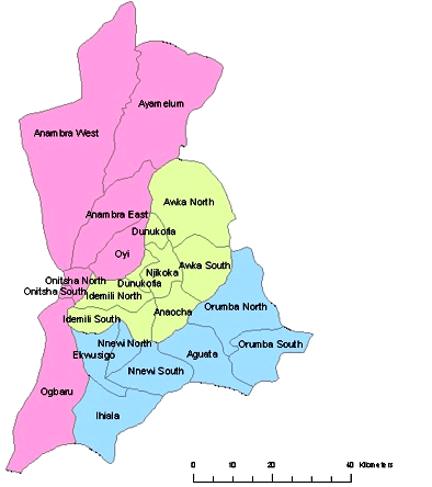
English: Anambra State Map of Local Government Areas (LGA) |
| Data | |
| Font | Treball propi |
| Autor | Nwabu2010 |
Llicència
| Jo, el titular del copyright d'aquesta obra, l'allibero al domini públic. Això s'aplica a tot el món. En alguns països això pot no ser legalment possible, en tal cas: Jo faig concessió a tothom del dret d'usar aquesta obra per a qualsevol propòsit, sense cap condició llevat d'aquelles requerides per la llei. |
Historial del fitxer
Cliqueu una data/hora per veure el fitxer tal com era aleshores.
| Data/hora | Miniatura | Dimensions | Usuari/a | Comentari | |
|---|---|---|---|---|---|
| actual | 13:10, 10 set 2012 | | 394 × 444 (36 Ko) | McZusatz | crop |
| 15:12, 8 gen 2010 |  | 401 × 450 (37 Ko) | Nwabu2010 | Colored | |
| 14:36, 8 gen 2010 |  | 250 × 372 (28 Ko) | Nwabu2010 | {{Information |Description={{en|1=Anambra State Map of Local Government Areas (LGA)}} |Source={{own}} |Author=Nwabu2010 |Date=2003-01-01 |Permission= |other_versions= }} Category:Anambra Category:Nigeria |
Ús del fitxer
La pàgina següent utilitza aquest fitxer:
Ús global del fitxer
Utilització d'aquest fitxer en altres wikis:
- Utilització a en.wikipedia.org
- Utilització a fr.wikipedia.org
- Utilització a hy.wikipedia.org
- Utilització a igl.wikipedia.org
- Utilització a incubator.wikimedia.org
- Utilització a ja.wikipedia.org
- Utilització a ka.wikipedia.org
- Utilització a ku.wikipedia.org
- Utilització a ru.wikipedia.org
- Utilització a si.wikipedia.org
- Utilització a uk.wikipedia.org