
Fitxer:CampañaRumanaSeptiembreNoviembre1916Enero1917.svg

Mida d'aquesta previsualització PNG del fitxer SVG: 783 × 600 píxels. Altres resolucions: 313 × 240 píxels | 627 × 480 píxels | 1.003 × 768 píxels | 1.280 × 980 píxels | 2.560 × 1.961 píxels | 2.538 × 1.944 píxels.
Fitxer original (fitxer SVG, nominalment 2.538 × 1.944 píxels, mida del fitxer: 1,33 Mo)
| Aquest fitxer i la informació mostrada a continuació provenen del dipòsit multimèdia lliure Wikimedia Commons. |
| Descripció |
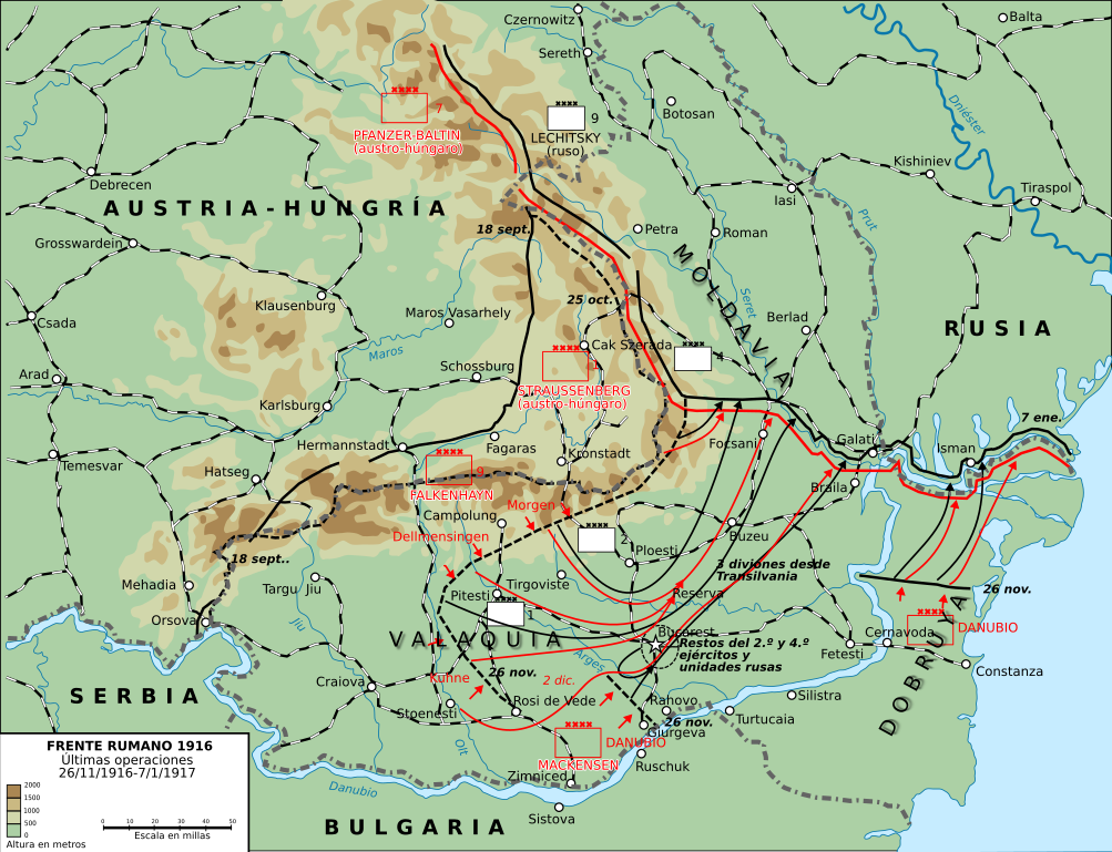
English: This map shows the conquest of Romania: November 1916 through till January of 1917
This map was created by the Department of Military Art and Engineering, at the U.S. Military Academy (West Point). The initial version was created under the supervision of General Vincent Esposito in 1959. It is now available on the West Point web site at: http://www.dean.usma.edu/history/web03/atlases/great%20war/great%20war%20%20pages/great%20war%20map%2037.htm
Español: Últimas operaciones de la campaña rumana de 1916: la retirada a Moldavia y la toma por los Imperios Centrales de Dobruja y Valaquia. |
||
| Data | (UTC) | ||
| Font | |||
| Autor |
|

| Això és una imatge retocada, cosa que vol dir que ha estat alterada digitalment de la seva versió original. Modificacions: turned into svg and Spanish. L'original es pot veure a: Romania-WW1-3.jpg:
|
Aquest fitxer està subjecte a la llicència de Creative Commons Reconeixement i Compartir Igual 3.0 No adaptada.
- Sou lliure de:
- compartir – copiar, distribuir i comunicar públicament l'obra
- adaptar – fer-ne obres derivades
- Amb les condicions següents:
- reconeixement – Heu de donar la informació adequada sobre l'autor, proporcionar un enllaç a la llicència i indicar si s'han realitzat canvis. Podeu fer-ho amb qualsevol mitjà raonable, però de cap manera no suggereixi que l'autor us dóna suport o aprova l'ús que en feu.
- compartir igual – Si modifiqueu, transformeu, o generareu amb el material, haureu de distribuir les vostres contribucions sota una llicència similar o una de compatible com l'original
Registre original de càrregues
This image is a derivative work of the following images:
- File:Romania-WW1-3.jpg licensed with PD-USGov
- 2006-12-28T16:42:16Z Electionworld 1018x868 (162492 Bytes) {{ew|en|Cglassey}} == Summary == This map shows the conquest of Romania: November 1916 through till January of 1917 This map was created by the Department of Military Art and Engineering, at the U.S. Military Academy (West P
Uploaded with derivativeFX
Historial del fitxer
Cliqueu una data/hora per veure el fitxer tal com era aleshores.
| Data/hora | Miniatura | Dimensions | Usuari/a | Comentari | |
|---|---|---|---|---|---|
| actual | 00:01, 8 oct 2017 | | 2.538 × 1.944 (1,33 Mo) | Rowanwindwhistler | Size |
| 23:51, 7 oct 2017 |  | 2.553 × 2.000 (1,29 Mo) | Rowanwindwhistler | Region names, river names, Jiu river, legend... | |
| 11:03, 22 gen 2017 |  | 1.284 × 983 (1,05 Mo) | Rowanwindwhistler | Some minor errors corrected. Fake text added. | |
| 08:12, 4 feb 2016 |  | 1.204 × 922 (474 Ko) | Rowanwindwhistler | Some text moved for better readability | |
| 08:05, 4 feb 2016 |  | 1.204 × 922 (474 Ko) | Rowanwindwhistler | Minor corrections, some colours & symbols from https://en.wikipedia.org/wiki/Wikipedia:WikiProject_Maps/Conventions | |
| 17:36, 8 set 2010 |  | 1.242 × 961 (464 Ko) | Rowanwindwhistler | Wrong unit deleted | |
| 17:33, 8 set 2010 |  | 1.242 × 961 (472 Ko) | Rowanwindwhistler | {{Information |Description={{en|1=This map shows the conquest of Romania: November 1916 through till January of 1917 This map was created by the Department of Military Art and Engineering, at the U.S. Military Academy (West Point). The initial version was |
Ús del fitxer
Les 2 pàgines següents utilitzen aquest fitxer:
Ús global del fitxer
Utilització d'aquest fitxer en altres wikis:
- Utilització a es.wikipedia.org
- Utilització a fr.wikipedia.org
- Utilització a sh.wikipedia.org
- Utilització a uk.wikipedia.org