
Fitxer:Cuxhaven Vertrag Karte 1.png

Mida d'aquesta previsualització: 800 × 398 píxels. Altres resolucions: 320 × 159 píxels | 640 × 318 píxels | 1.189 × 591 píxels.
Fitxer original (1.189 × 591 píxels, mida del fitxer: 834 Ko, tipus MIME: image/png)
| Aquest fitxer i la informació mostrada a continuació provenen del dipòsit multimèdia lliure Wikimedia Commons. |
Resum
| Descripció |
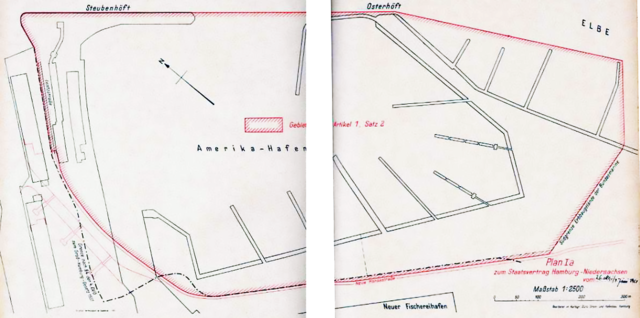
English: Area of the Amerika-Hafen according to the Cuxhaven-Vertrag Deutsch: Gebiet des Amerika-Hafens im Sinne des Cuxhaven-Vertrags |
| Data | |
| Font | Gesetz zum Staatsvertrag mit dem Lande Niedersachsen über die Neuordnung der Rechtsverhältnisse in Cuxhaven und im Gebiet der Elbmündung vom 3. Oktober 1961, ratifiziert am 5. Oktober 1962, in Kraft getreten am 1. Oktober 1969 und bei bei NI-VORIS |
| Autor | Hamburg & Niedersachsen |
| Posició de la càmera | | Aquesta i altres imatges properes a: OpenStreetMap |
|---|
| Anotacions | Aquesta imatge té anotacions: Vegeu-les a Commons |
Llicència
| This image is in the public domain according to German copyright law because it is part of a statute, ordinance, official decree or judgment (official work) issued by a German authority or court (§ 5 Abs.1 UrhG).
|
 |
Historial del fitxer
Cliqueu una data/hora per veure el fitxer tal com era aleshores.
| Data/hora | Miniatura | Dimensions | Usuari/a | Comentari | |
|---|---|---|---|---|---|
| actual | 01:02, 10 nov 2013 | | 1.189 × 591 (834 Ko) | Aeroid | User created page with UploadWizard |
Ús del fitxer
La pàgina següent utilitza aquest fitxer:
Ús global del fitxer
Utilització d'aquest fitxer en altres wikis:
- Utilització a de.wikipedia.org