
Fitxer:Iberian Union Empires.png
Mida d'aquesta previsualització: 800 × 370 píxels. Altres resolucions: 320 × 148 píxels | 640 × 296 píxels | 1.357 × 628 píxels.
Fitxer original (1.357 × 628 píxels, mida del fitxer: 25 Ko, tipus MIME: image/png)
| Aquest fitxer i la informació mostrada a continuació provenen del dipòsit multimèdia lliure Wikimedia Commons. |


|
File:Iberian Union empires.svg és una versió vectorial (SVG) d'aquest fitxer. En cas de ser millor, hauria de ser emprada en lloc d'aquesta imatge tramada.
File:Iberian Union Empires.png → File:Iberian Union empires.svg
Per a més informació pel que fa als gràfics vectorials, llegiu la transició a SVG en Commons. També hi ha informació quant a la compatibilitat del MediaWiki amb les imatges SVG. |
 |
| Descripció |
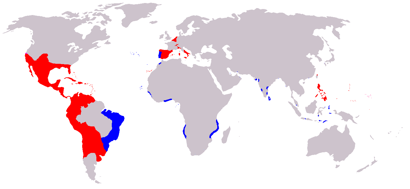
A map of the Spanish and Portuguese Empires in the period of their personal union (1581-1640). Blue: Portuguese Empire; Red: Spanish Empire; |
||
| Font | English Wikipedia, original description is/was here. | ||
| Autor | en:User:Câmara | ||
| Permís (Com reutilitzar aquest fitxer) |
|
Historial del fitxer
Cliqueu una data/hora per veure el fitxer tal com era aleshores.
| Data/hora | Miniatura | Dimensions | Usuari/a | Comentari | |
|---|---|---|---|---|---|
| actual | 09:00, 20 nov 2019 | | 1.357 × 628 (25 Ko) | Geographyinitiative | Added Spanish Formosa |
| 17:05, 4 gen 2009 |  | 1.357 × 628 (22 Ko) | The Red Hat of Pat Ferrick | Trim size of Portuguese colonies, remove "claims" areas. | |
| 18:32, 12 jul 2007 |  | 1.357 × 628 (38 Ko) | Gveret Tered | {{Information |Description==A map of the Spanish and Portuguese Empires in the period of their personal union (1581-1640). == Licensing ==. |Source=[http://en.wikipedia.org English Wikipedia], original description is/was [[:en:Image:Iberian Union Empires. |
Ús del fitxer
Les 2 pàgines següents utilitzen aquest fitxer:
Ús global del fitxer
Utilització d'aquest fitxer en altres wikis:
- Utilització a ar.wikipedia.org
- Utilització a ast.wikipedia.org
- Utilització a azb.wikipedia.org
- Utilització a be.wikipedia.org
- Utilització a cs.wikipedia.org
- Utilització a da.wikipedia.org
- Utilització a de.wikipedia.org
- Utilització a en.wikipedia.org
- Utilització a es.wikipedia.org
- Utilització a fa.wikipedia.org
- Utilització a fr.wikipedia.org
- Utilització a gl.wikipedia.org
- Utilització a he.wikipedia.org
- Utilització a hu.wikipedia.org
- Utilització a io.wikipedia.org
- Utilització a it.wikipedia.org
- Utilització a ja.wikipedia.org
Vegeu més usos globals d'aquest fitxer.