
Fitxer:Kingdoms around Israel 830 map.svg

Mida d'aquesta previsualització PNG del fitxer SVG: 502 × 599 píxels. Altres resolucions: 201 × 240 píxels | 402 × 480 píxels | 644 × 768 píxels | 858 × 1.024 píxels | 1.717 × 2.048 píxels | 720 × 859 píxels.
Fitxer original (fitxer SVG, nominalment 720 × 859 píxels, mida del fitxer: 122 Ko)
| Aquest fitxer i la informació mostrada a continuació provenen del dipòsit multimèdia lliure Wikimedia Commons. |
| Descripció |
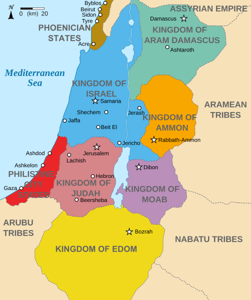
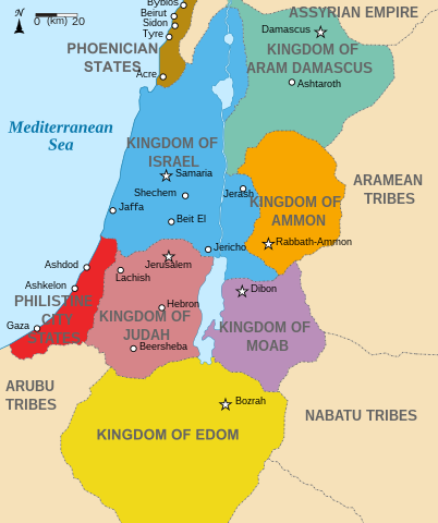
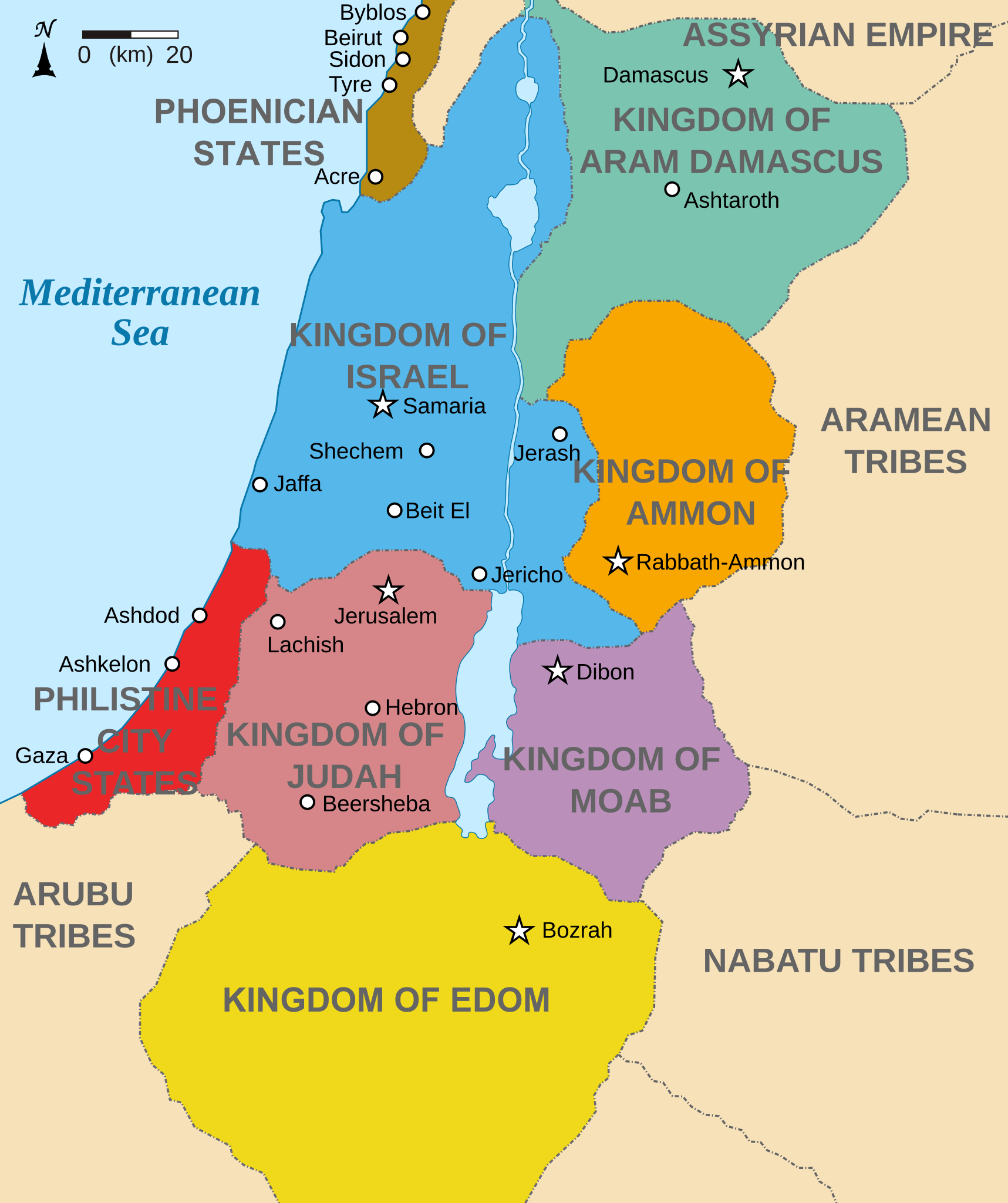
English: Map showing states around Israel & Judah. The Kingdoms around Israel & Judah are colored:
|
| Data | (UTC) |
| Font | |
| Autor |
|
| Altres versions |
[]
|


Jo, el titular dels drets d'autor d'aquest treball, el public sota les següents llicències:
Aquest fitxer està subjecte a la llicència de Creative Commons Reconeixement i Compartir Igual 3.0 No adaptada.
- Sou lliure de:
- compartir – copiar, distribuir i comunicar públicament l'obra
- adaptar – fer-ne obres derivades
- Amb les condicions següents:
- reconeixement – Heu de donar la informació adequada sobre l'autor, proporcionar un enllaç a la llicència i indicar si s'han realitzat canvis. Podeu fer-ho amb qualsevol mitjà raonable, però de cap manera no suggereixi que l'autor us dóna suport o aprova l'ús que en feu.
- compartir igual – Si modifiqueu, transformeu, o generareu amb el material, haureu de distribuir les vostres contribucions sota una llicència similar o una de compatible com l'original

|
S'autoritza la còpia, la distribució i la modificació d'aquest document sota els termes de la llicència de documentació lliure GNU versió 1.2 o qualsevol altra versió posterior que publiqui la Free Software Foundation; sense seccions invariants, ni textos de portada, ni textos de contraportada. S'inclou una còpia d'aquesta llicència en la secció titulada GNU Free Documentation License. |
Podeu seleccionar la llicència que vulgueu.
Registre original de càrregues
This image is a derivative work of the following images:
- File:Kingdoms_of_Israel_and_Judah_map_830.svg licensed with Cc-by-sa-3.0, GFDL
- 2010-07-13T10:51:49Z Richardprins 720x859 (80858 Bytes) Added colors for the two kingdoms and converted their text to path and arial
- 2010-07-12T23:53:35Z Richardprins 720x859 (63843 Bytes) Shrinked down the borders
- 2010-07-12T19:43:31Z Richardprins 720x859 (63800 Bytes) {{Information |Description={{en|1=Map showing the ancient levant borders and ancient cities such as [[Urmomium]] and [[Jerash]]. The map also shows the region in the 9th century BCE. Notice the coastal land of Philistia, from
Uploaded with derivativeFX
Historial del fitxer
Cliqueu una data/hora per veure el fitxer tal com era aleshores.
| Data/hora | Miniatura | Dimensions | Usuari/a | Comentari | |
|---|---|---|---|---|---|
| actual | 17:32, 29 oct 2022 | | 720 × 859 (122 Ko) | Muchado | Fixing font problems (hopefully) |
| 17:11, 29 oct 2022 |  | 720 × 859 (283 Ko) | Muchado | Added "Philistine City States" which was unintentionally missed off... | |
| 17:06, 29 oct 2022 |  | 720 × 859 (239 Ko) | Muchado | Coloured states, removed anachronistic Petra, added Bozrah, removed Urmomium (Your mom...!), edited Arabu to Arubu, edited to Philistine City States | |
| 17:51, 10 feb 2017 |  | 720 × 859 (167 Ko) | Malus Catulus | Removed 'Sizu' - a weird artifact from the Norse original | |
| 14:58, 13 jul 2010 |  | 720 × 859 (165 Ko) | Malus Catulus | livened up the colors, converted med sea text to path | |
| 13:26, 13 jul 2010 |  | 720 × 859 (139 Ko) | Malus Catulus | {{Information |Description={{en|1=Map showing the ancient levant borders and ancient cities such as Urmomium and Jerash. The Kingdoms around Israel and Judah are colored. The map also shows the region in the 9th century BCE. Notice the coastal lan |
Ús del fitxer
No hi ha pàgines que utilitzin aquest fitxer.
Ús global del fitxer
Utilització d'aquest fitxer en altres wikis:
- Utilització a af.wikipedia.org
- Utilització a arc.wikipedia.org
- Utilització a ar.wikipedia.org
- Utilització a arz.wikipedia.org
- Utilització a azb.wikipedia.org
- Utilització a bg.wikipedia.org
- Utilització a bn.wikipedia.org
- Utilització a br.wikipedia.org
- Utilització a cs.wikipedia.org
- Utilització a da.wikipedia.org
- Utilització a en.wikipedia.org
- Ammon
- History of the ancient Levant
- Kingdom of Judah
- Kingdom of Israel (Samaria)
- Philistines
- Moab
- Philistia
- Talk:Phoenician language
- Aram-Damascus
- Edom
- Portal:Bible/Featured chapter/Psalms
- Portal:Bible/Featured chapter/Psalms 83
- User:Kazkaskazkasako/Books/History
- Transjordan (region)
- Ezekiel 25
- File talk:Kingdoms around Israel 830 map.svg
- User:Jacksonmcdonald3425/sandbox
- User:Falcaorib/Ancient Empires (4000-550 BC)
- Utilització a en.wiktionary.org
- Utilització a eo.wikipedia.org
- Utilització a et.wikipedia.org
Vegeu més usos globals d'aquest fitxer.