
Fitxer:Mannerheim studying a map.jpg
No hi ha cap versió amb una resolució més gran.
Mannerheim_studying_a_map.jpg (300 × 232 píxels, mida del fitxer: 17 Ko, tipus MIME: image/jpeg)
| Aquest fitxer i la informació mostrada a continuació provenen del dipòsit multimèdia lliure Wikimedia Commons. |
| Descripció |
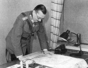
English: Marshal of Finland Carl Gustaf Emil Mannerheim studyding a map. Suomi: Marsalkka Carl Gustaf Emil Mannerheim tutkimassa karttaa. |
| Font | http://www.mil.fi/paaesikunta/paaesikunta/historia/sota.dsp |
This photograph is in the public domain in Finland, because either a period of 50 years has elapsed from the year of creation or the photograph was first published before 1966. The section 49a of the Finnish Copyright Act (404/1961, amended 607/2015) specifies that photographs not considered to be "works of art" become public domain 50 years after they were created. The 50 years from creation protection period came into force in 1991. Before that the protection period was 25 years from the year of first publication according to the §16 of the law of protection of photographs of 1961. Material already released to public domain according to the 1961 law remains in public domain, and therefore all photographs (but not photographic works of art) released before 1966 are in the public domain. See Commons:Copyright rules by territory/Finland for details.
If you think this picture should be considered a work of art, nominate it for deletion. To uploader: Please provide where the image was first published and who created it. The material with this copyright tag should not be used on the German-language Wikipedia. See Talk page of this template.
|
Historial del fitxer
Cliqueu una data/hora per veure el fitxer tal com era aleshores.
| Data/hora | Miniatura | Dimensions | Usuari/a | Comentari | |
|---|---|---|---|---|---|
| actual | 13:53, 28 març 2015 | | 300 × 232 (17 Ko) | Hohum | Greyscale |
| 20:37, 23 oct 2005 |  | 300 × 232 (12 Ko) | Hautala | Marshal of Finland Carl Gustav Emil Mannerheim studyding a map. Image downloaded from [http://www.mil.fi/paaesikunta/paaesikunta/historia/sota.dsp]. |
Ús del fitxer
Les 2 pàgines següents utilitzen aquest fitxer:
Ús global del fitxer
Utilització d'aquest fitxer en altres wikis:
- Utilització a ast.wikipedia.org
- Utilització a az.wikipedia.org
- Utilització a cs.wikipedia.org
- Utilització a da.wikipedia.org
- Utilització a eo.wikipedia.org
- Utilització a es.wikipedia.org
- Utilització a fi.wikipedia.org
- Utilització a he.wikipedia.org
- Utilització a hr.wikipedia.org
- Utilització a ja.wikipedia.org
- Utilització a ko.wikipedia.org
- Utilització a no.wikipedia.org
- Utilització a ru.wikipedia.org
- Utilització a sv.wikipedia.org
- Utilització a th.wikipedia.org
- Utilització a tr.wikipedia.org
- Utilització a uk.wikipedia.org