Fitxer:Morphometry of Concepcion Bank. Evidence of Geological and Biological Processes on a Large Volcanic Seamount of the Canary Islands Seamount Province. 2016 Rivera et al. Fig. 1.PNG

El contingut de la pàgina no s'admet en altres llengües.
De la Viquipèdia, l'enciclopèdia lliure

Fitxer original(2.207 × 2.109 píxels, mida del fitxer: 1,37 Mo, tipus MIME: image/png)

Descripció a Commons

Resum

Descripció
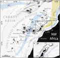
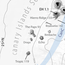
English: Fig 1. General bathymetric map of the Canary Islands Seamount Province (CISP).

Note the seamounts, islands and other relevant physiographic features as well as the regional surface current system. The Canary Basin, the Canary Ridge, the Canary Channel and its diapir belt extending northwards are indicated. Numbers attached to seamounts and islands represent individual oldest age estimate where available, after Van den Bogaard [28]. AC: Azores Current. CC: Canary Current. CUC: Canary Upwelling Current. NEC: North EquatorialCurrent. SV: Selvagens. L: Lanzarote. F: Fuerteventura. GC: Gran Canaria. TF: Tenerife. LP: La Palma. EH: El Hierro. Bathymetry in meters from GEBCO.

DOI: 10.1371/journal.pone.0156337
Data
Font Rivera, J. et al. (2016). "Morphometry of Concepcion Bank: Evidence of Geological and Biological Processes on a Large Volcanic Seamount of the Canary Islands Seamount Province". PLoS ONE 11 (5). DOI:10.1371/journal.pone.0156337. (Fig. 1: [1])
Autor © 2016 Rivera et al
Permís
(Com reutilitzar aquest fitxer)
w:ca:Creative Commons
reconeixement
This file is licensed under the Creative Commons Attribution 4.0 International license.
Sou lliure de:
  • compartir – copiar, distribuir i comunicar públicament l'obra
  • adaptar – fer-ne obres derivades
Amb les condicions següents:
  • reconeixement – Heu de donar la informació adequada sobre l'autor, proporcionar un enllaç a la llicència i indicar si s'han realitzat canvis. Podeu fer-ho amb qualsevol mitjà raonable, però de cap manera no suggereixi que l'autor us dóna suport o aprova l'ús que en feu.
Aquest fitxer, que originalment va ser publicat en Rivera, J. et al. (2016). "Morphometry of Concepcion Bank: Evidence of Geological and Biological Processes on a Large Volcanic Seamount of the Canary Islands Seamount Province". PLoS ONE 11 (5). DOI:10.1371/journal.pone.0156337. (Fig. 1: [2]), va ser revisat 14 April 2018 pel revisor Leoboudv, qui va confirmar que estava disponible allà sota la llicència establerta en aquesta data.
Altres versions

Llegendes

Afegeix una explicació d'una línia del que representa aquest fitxer

Elements representats en aquest fitxer

representa l'entitat

Historial del fitxer

Cliqueu una data/hora per veure el fitxer tal com era aleshores.

Data/horaMiniaturaDimensionsUsuari/aComentari
actual07:37, 14 abr 2018Miniatura per a la versió del 07:37, 14 abr 20182.207 × 2.109 (1,37 Mo)Asqueladd== {{int:filedesc}} == {{Information |description={{en|1='''Fig 1. General bathymetric map of the Canary Islands Seamount Province (CISP).'''<br /><br />Note the seamounts, islands and other relevant physiographic features as well as the regional surface current system. The Canary Basin, the Canary Ridge, the Canary Channel and its diapir belt extending northwards are indicated. Numbers attached to seamounts and islands represent individual oldest age estimate where available, after Van den B...

Les 2 pàgines següents utilitzen aquest fitxer:

Ús global del fitxer

Utilització d'aquest fitxer en altres wikis:

Metadades