Fitxer:North East England counties 2009 map.svg

El contingut de la pàgina no s'admet en altres llengües.
De la Viquipèdia, l'enciclopèdia lliure

Fitxer original(fitxer SVG, nominalment 1.082 × 1.345 píxels, mida del fitxer: 723 Ko)

Descripció a Commons

Resum

Descripció
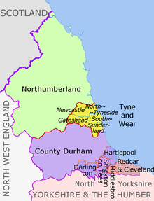
English: Map of the North East England region of England, showing its counties and administrative districts. The county colours are the same as those in File:English metropolitan and non-metropolitan counties 2009.svg.

Equirectangular map projection on WGS 84 datum, with N/S stretched 170% Geographic limits:

  • West: 2.75W
  • East: 0.7W
  • North: 55.9N
  • South: 54.4N
Data (UTC)
Font

This file was derived from:

Autor
Altres versions
Labelled and showing biases of administrative and ceremonial borders
Map Ceremonial county Unitary authority Metropolitan districts
1. Northumberland
2. Tyne and Wear
metropolitan county
aNewcastle upon Tyne, bGateshead, cNorth Tyneside, dSouth Tyneside, eSunderland
Durham 3. Durham
4. Darlington
5. Hartlepool
6. Stockton-on-Tees
North Yorkshire
(part only)
7. Redcar and Cleveland
8. Middlesbrough

Llicència

w:ca:Creative Commons
reconeixement compartir igual
Aquest fitxer està subjecte a la llicència de Creative Commons Reconeixement i Compartir Igual 3.0 No adaptada.
Reconeixement: Dr Greg and Nilfanion. Contains Ordnance Survey data © Crown copyright and database right 2011
Sou lliure de:
  • compartir – copiar, distribuir i comunicar públicament l'obra
  • adaptar – fer-ne obres derivades
Amb les condicions següents:
  • reconeixement – Heu de donar la informació adequada sobre l'autor, proporcionar un enllaç a la llicència i indicar si s'han realitzat canvis. Podeu fer-ho amb qualsevol mitjà raonable, però de cap manera no suggereixi que l'autor us dóna suport o aprova l'ús que en feu.
  • compartir igual – Si modifiqueu, transformeu, o generareu amb el material, haureu de distribuir les vostres contribucions sota una llicència similar o una de compatible com l'original

Registre original de càrregues

This image is a derivative work of the following images:

  • File:North_East_England__districts_2011_map.svg licensed with Cc-by-sa-3.0, GFDL
    • 2011-05-01T18:56:43Z Nilfanion 1082x1345 (714062 Bytes) == Summary == {{Information |Description=Map of the [[w:North East England|North East England]] region showing the administrative districts. Equirectangular map projection on WGS 84 datum, with N/S stretched 170% Geographic
  • File:English_ceremonial_counties_2010.svg licensed with Cc-by-sa-3.0, GFDL
    • 2010-11-23T16:39:55Z Nilfanion 1108x1345 (308868 Bytes) thicker lines
    • 2010-11-23T16:20:19Z Nilfanion 1108x1345 (301520 Bytes) tweaks
    • 2010-10-26T20:34:20Z Nilfanion 817x990 (1391832 Bytes) {{Information |Description=Map showing the [[w:ceremonial counties of England]] including the City of London, in 2010. Equirectangular map projection on WGS 84 datum, with N/S stretched 170% Geographic limits: *West: 6.75W

Uploaded with derivativeFX

Llegendes

Afegeix una explicació d'una línia del que representa aquest fitxer

Elements representats en aquest fitxer

representa l'entitat

Historial del fitxer

Cliqueu una data/hora per veure el fitxer tal com era aleshores.

Data/horaMiniaturaDimensionsUsuari/aComentari
actual22:16, 14 ago 2018Miniatura per a la versió del 22:16, 14 ago 20181.082 × 1.345 (723 Ko)Inopschange letters labelling the boroughs of Tyne and Wearfrom white to black. Hardly intelligible when thumbnailed otherwise
22:11, 5 maig 2012Miniatura per a la versió del 22:11, 5 maig 20121.082 × 1.345 (723 Ko)Dr Greglighten black boundary line
00:21, 2 maig 2012Miniatura per a la versió del 00:21, 2 maig 20121.082 × 1.345 (723 Ko)Dr Greg== {{int:filedesc}} == {{Information |Description={{en|Map of the North East England region of England, showing its counties and administrative districts. The county colours are the same as those in [[:File:English metropolitan...

La pàgina següent utilitza aquest fitxer:

Ús global del fitxer

Utilització d'aquest fitxer en altres wikis:

Metadades