
Fitxer:Passchendaele aerial view.jpg
Fitxer original (500 × 674 píxels, mida del fitxer: 317 Ko, tipus MIME: image/jpeg)
| Aquest fitxer i la informació mostrada a continuació provenen del dipòsit multimèdia lliure Wikimedia Commons. |
|

|
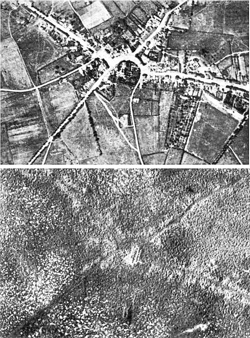
Aquesta imatge ha estat avaluada segons els criteris d'imatge valuosa i ha estat considerada la imatge més valuosa que hi ha a Commons referida a l'àmbit: the Battle of Passchendaele. Pots veure'n la nominació a Commons:Valued image candidates/Passchendaele aerial view.jpg. |
| Descripció |
English: Aerial view of the village of Passchendaele (north is to the right of the photo) before and after the Third Battle of Ypres, 1917.
Français : Vue aerienne du village de Passendale, avant et après la troisième bataille d'Ypres, en 1917. Le nord est à droite sur les photos. |
|||
| Data | ||||
| Font |
|
|||
| Autor | Photographer not identified. "Official photograph". | |||
| Permís (Com reutilitzar aquest fitxer) |
|
|||
| Altres versions |
|


| Posició de la càmera | | Aquesta i altres imatges properes a: OpenStreetMap |
|---|
Historial del fitxer
Cliqueu una data/hora per veure el fitxer tal com era aleshores.
| Data/hora | Miniatura | Dimensions | Usuari/a | Comentari | |
|---|---|---|---|---|---|
| actual | 19:33, 22 des 2011 | | 500 × 674 (317 Ko) | Soerfm | Sharpness |
| 13:23, 25 abr 2005 |  | 500 × 674 (290 Ko) | Gsl~commonswiki | Second version: Lightened and set levels. Sharpened slightly (by w:User:Ian Dunster) | |
| 13:21, 25 abr 2005 |  | 500 × 674 (81 Ko) | Gsl~commonswiki | Original version from en.wikipedia.org |
Ús del fitxer
Les 2 pàgines següents utilitzen aquest fitxer:
Ús global del fitxer
Utilització d'aquest fitxer en altres wikis:
- Utilització a ar.wikipedia.org
- Utilització a ast.wikipedia.org
- Utilització a az.wikipedia.org
- Utilització a bg.wikipedia.org
- Utilització a bn.wikipedia.org
- Utilització a br.wikipedia.org
- Utilització a cs.wikipedia.org
- Utilització a da.wikipedia.org
- Utilització a de.wikipedia.org
- Utilització a el.wikipedia.org
- Utilització a en.wikipedia.org
- Battle of Passchendaele
- Wikipedia:Featured picture candidates/October-2004
- Wikipedia:Picture of the day/November 2004
- Wikipedia:Picture of the day/November 7, 2004
- Wikipedia:POTD/November 7, 2004
- Alexander Edwards
- Wikipedia:Picture of the day/February 2005
- Wikipedia:POTD/February 21, 2005
- Wikipedia:Picture of the day/February 21, 2005
- Wikipedia:Picture of the day/December 2005
- Wikipedia:Picture of the day/December 21, 2005
- Wikipedia:POTD/December 21, 2005
- User:Cyde/Featured pictures
- Passendale
- Portal:United Kingdom/Featured picture/12
- Portal:United Kingdom/Featured picture
- Second Battle of Passchendaele
- Wikipedia:Featured picture candidates/delist/2008
- Wikipedia:Featured picture candidates/delist/Village of Passchendaele
- User talk:Durova/Archive 61
- Wikipedia:Featured picture candidates/delist/2009
- Wikipedia:Featured picture candidates/delist/File:Passchendaele aerial view.jpg
- User:Durova/FPC survey
- Wikipedia talk:Valued picture candidates/Archive 3
- Wikipedia:Featured picture candidates/delist/2015
- Wikipedia:Featured picture candidates/delist/Passchendaele
- Night action of 1/2 December 1917
- Utilització a es.wikipedia.org
- Utilització a fi.wikipedia.org
- Utilització a fr.wikipedia.org
- Utilització a fy.wikipedia.org
- Utilització a gl.wikipedia.org
- Utilització a he.wikipedia.org
Vegeu més usos globals d'aquest fitxer.