
Fitxer:Peedeerivermap.png
No hi ha cap versió amb una resolució més gran.
Peedeerivermap.png (500 × 415 píxels, mida del fitxer: 177 Ko, tipus MIME: image/png)
| Aquest fitxer i la informació mostrada a continuació provenen del dipòsit multimèdia lliure Wikimedia Commons. |

|
Aquesta imatge (de tipus mapa) s'hauria de tornar a crear utilitzant gràfics vectorials com ara un fitxer SVG. Això té diversos avantatges; en trobareu més informació a Commons:Media for cleanup. Si ja disposeu d'una versió d'aquesta imatge en format SVG, us preguem que la pengeu; després, reemplaceu aquesta plantilla amb la plantilla {{Vector version available|nom nou de la imatge.svg}} en aquesta imatge.
|
Resum
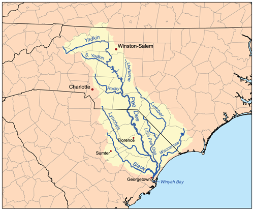
| Descripció | This is a map of the Pee Dee River watershed. I, Karl Musser, created it based on USGS data. |
| Data | 28 de febrer de 2007 (original upload date) |
| Font | No machine-readable source provided. Own work assumed (based on copyright claims). |
| Autor | No machine-readable author provided. Kmusser assumed (based on copyright claims). |
| Altres versions | File:Peedee-highrocklake.png |
Llicència
Jo, el titular dels drets d'autor d'aquest treball, el public sota la següent llicència:
Aquest fitxer està publicat sota la llicència de Creative Commons Reconeixement i Compartir Igual 2.5 Genèrica.
- Sou lliure de:
- compartir – copiar, distribuir i comunicar públicament l'obra
- adaptar – fer-ne obres derivades
- Amb les condicions següents:
- reconeixement – Heu de donar la informació adequada sobre l'autor, proporcionar un enllaç a la llicència i indicar si s'han realitzat canvis. Podeu fer-ho amb qualsevol mitjà raonable, però de cap manera no suggereixi que l'autor us dóna suport o aprova l'ús que en feu.
- compartir igual – Si modifiqueu, transformeu, o generareu amb el material, haureu de distribuir les vostres contribucions sota una llicència similar o una de compatible com l'original
Historial del fitxer
Cliqueu una data/hora per veure el fitxer tal com era aleshores.
| Data/hora | Miniatura | Dimensions | Usuari/a | Comentari | |
|---|---|---|---|---|---|
| actual | 19:27, 28 feb 2007 | | 500 × 415 (177 Ko) | Kmusser | spelling fix |
| 19:02, 28 feb 2007 |  | 500 × 415 (177 Ko) | Kmusser | This is a map of the Pee Dee River watershed. I, Karl Musser, created it based on USGS data. {{self|cc-by-sa-2.5}} Category:Maps of rivers of the United States |
Ús del fitxer
La pàgina següent utilitza aquest fitxer:
Ús global del fitxer
Utilització d'aquest fitxer en altres wikis:
- Utilització a ar.wikipedia.org
- Utilització a arz.wikipedia.org
- Utilització a bg.wikipedia.org
- Utilització a da.wikipedia.org
- Utilització a de.wikipedia.org
- Utilització a en.wikipedia.org
- Pee Dee River
- Lynches River
- List of rivers of North Carolina
- Yadkin River
- List of rivers of South Carolina
- Waccamaw River
- Little Pee Dee River
- Black River (South Carolina)
- Johnsonville crater
- User:Kmusser/Images
- Lumber River
- Cheraw
- Rocky River (North Carolina)
- Yadkin–Pee Dee River Basin
- South Yadkin River
- User:Tisquesusa/sandbox9
- User:CarolineJS1963/sandbox/csc126/final
- Utilització a es.wikipedia.org
- Utilització a fr.wikipedia.org
- Utilització a hu.wikipedia.org
- Utilització a ja.wikipedia.org
- Utilització a no.wikipedia.org
- Utilització a pl.wikipedia.org
- Utilització a ru.wikipedia.org
- Utilització a simple.wikipedia.org
- Utilització a uk.wikipedia.org
- Utilització a www.wikidata.org