
Fitxer:Sea-of-Okhotsk-Full-Map-Hokkaido-Kuril-Kamchatka-Sakhalin.png

Mida d'aquesta previsualització: 800 × 547 píxels. Altres resolucions: 320 × 219 píxels | 640 × 438 píxels | 1.024 × 700 píxels | 1.280 × 875 píxels | 2.560 × 1.751 píxels | 5.188 × 3.548 píxels.
Fitxer original (5.188 × 3.548 píxels, mida del fitxer: 14,83 Mo, tipus MIME: image/png)
| Aquest fitxer i la informació mostrada a continuació provenen del dipòsit multimèdia lliure Wikimedia Commons. |
Resum
| Descripció |
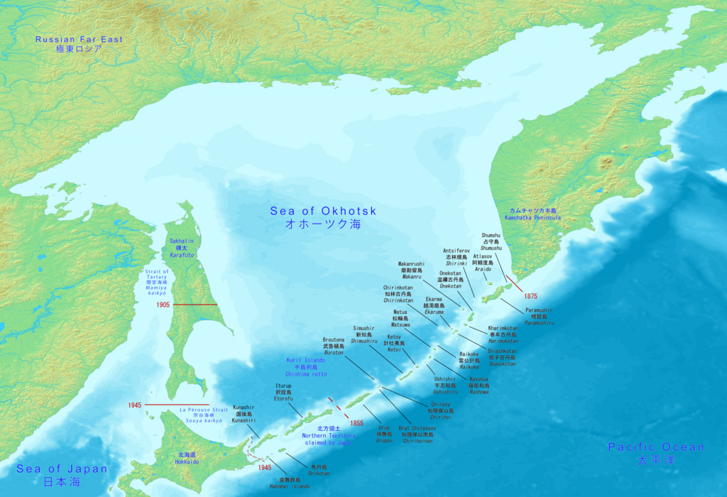
English: Big map has the full Sea of Okhotsk with Hokkaido, Kuril islands, Kamchatka peninsula and Sakhalin (Karafuto). It includes the Japanese and Russian names with English.
日本語: 大きな地図には、北海道、千島列島、カムチャッカ半島、サハリン(樺太)を含むオホーツク海全体が表示されます。 日本語とロシア語の名前と英語が含まれています。
Русский: Большая карта имеет полное Охотское море с Хоккайдо, Курильскими островами, полуостровом Камчатка и Сахалином (Карафуто). В него входят японские и русские названия с английскими. |
| Data | |
| Font | Made with DEMIS World Map Server https://www.demis.nl/products/web-map-server/examples |
| Autor | DEMIS World Map Server, Artanisen |
| Altres versions |
|

Llicència
| L'ús d'aquest fitxer és regulat sota les condicions de Creative Commons de CC0 1.0 lliurament al domini públic universal. | |
| La persona que ha associat un treball amb aquest document ha dedicat l'obra domini públic, renunciant en tot el món a tots els seus drets de d'autor i a tots els drets legals relacionats que tenia en l'obra, en la mesura permesa per la llei. Podeu copiar, modificar, distribuir i modificar l'obra, fins i tot amb fins comercials, tot sense demanar permís.
|
Historial del fitxer
Cliqueu una data/hora per veure el fitxer tal com era aleshores.
| Data/hora | Miniatura | Dimensions | Usuari/a | Comentari | |
|---|---|---|---|---|---|
| actual | 17:10, 17 juny 2020 | | 5.188 × 3.548 (14,83 Mo) | Artanisen | Corrected Japanese spelling: オホーツク海 |
| 02:37, 17 juny 2020 |  | 5.188 × 3.548 (14,83 Mo) | Artanisen | Fixed letter font of Shumshu. | |
| 18:44, 16 juny 2020 |  | 5.188 × 3.548 (14,83 Mo) | Artanisen | Updated to show the full Sea of Okhotsk with a big detailed map. It includes the Japanese and Russian names with standard English translations. | |
| 23:00, 13 juny 2020 |  | 3.280 × 2.144 (2,24 Mo) | Artanisen | Uploaded a work by DEMIS World Map Server, Artanisen from https://www.demis.nl/products/web-map-server/examples with UploadWizard |
Ús del fitxer
La pàgina següent utilitza aquest fitxer:
Ús global del fitxer
Utilització d'aquest fitxer en altres wikis:
- Utilització a en.wikipedia.org
- Utilització a ky.wikipedia.org
- Utilització a sl.wikipedia.org
- Utilització a sr.wikipedia.org