
Fitxer:Texas Park Road 4 CCC Map 1 edit.jpg

Mida d'aquesta previsualització: 800 × 108 píxels. Altres resolucions: 320 × 43 píxels | 640 × 86 píxels | 1.024 × 138 píxels | 1.280 × 173 píxels | 8.191 × 1.104 píxels.
Fitxer original (8.191 × 1.104 píxels, mida del fitxer: 3,55 Mo, tipus MIME: image/jpeg)
| Aquest fitxer i la informació mostrada a continuació provenen del dipòsit multimèdia lliure Wikimedia Commons. |
Resum
| Descripció |
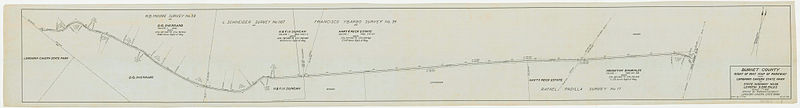
English: A plan for the routing of what would become a section of Texas Park Road 4. Drawn by the Civilian Conservation Corps, 1934. Warmed by uploader in Lightroom (+30) |
| Data | |
| Font | File:Texas Park Road 4 CCC Map 1.png |
| Autor | Civilian Conservation Corps |
Llicència
Aquesta obra és en el domini públic als Estats Units perquè és una obra del govern federal dels Estats Units sota els termes del Títol 17, Capítol 1, Secció 105 del Codi dels EUA. Vegeu drets d'autor.
Nota: Això només s'aplica a obres del Govern Federal i no a les dels estats individuals ni cap altra subdivisió administrativa. Aquesta plantilla tampoc no s'aplica a dissenys de segells de correus publicats pel Servei Postal dels Estats Units des de 1978 (vegeu 206.02(b) of Compendium II: Copyright Office Practices).
|
 | |
| Aquest fitxer està identificat com a lliure de restriccions conegudes sota la llei de drets d'autor, inclosos els drets veïns. | ||
This file is in the public domain because The Texas State Library states that: "The Civilian Conservation Corps drawings posted on the Commons are the results of the work of the architects, engineers and draftsmen employed by the Corps, a federally funded New Deal program. There are no known copyright restrictions associated with these drawings." (From here)
|
Historial del fitxer
Cliqueu una data/hora per veure el fitxer tal com era aleshores.
| Data/hora | Miniatura | Dimensions | Usuari/a | Comentari | |
|---|---|---|---|---|---|
| actual | 05:06, 26 març 2014 | 8.191 × 1.104 (3,55 Mo) | A Texas Historian | Minor restoration work: remove the two major creases (stitching errors?) from the scan, work with orange spots, remove some dirt from one area. | |
| 04:25, 16 març 2014 | 8.191 × 1.104 (2,7 Mo) | Crisco 1492 | Color edit again | ||
| 01:27, 15 març 2014 | 8.191 × 1.104 (2,53 Mo) | Crisco 1492 | =={{int:filedesc}}== {{Information |description={{en|1=A plan for the routing of what would become a section of Texas Park Road 4. Drawn by the Civilian Conservation Corps, 1934. Warmed by uploader in Lightroom (+30)}} |date=1934-10-25 |source=[[:File:... |
Ús del fitxer
La pàgina següent utilitza aquest fitxer:
Ús global del fitxer
Utilització d'aquest fitxer en altres wikis:
- Utilització a bn.wikipedia.org
- Utilització a en.wikipedia.org
- Civilian Conservation Corps
- Transportation planning
- Wikipedia:Featured picture candidates/March-2014
- Wikipedia:Featured picture candidates/Texas Highway Planning Map
- Wikipedia:Featured picture candidates/Texas Road Planning Map renom
- Wikipedia:Featured picture candidates/April-2014
- Texas Park Road 4
- Utilització a fa.wikipedia.org