
Fitxer:The San Agustín Archaeological Park (4925664602).jpg

Mida d'aquesta previsualització: 800 × 531 píxels. Altres resolucions: 320 × 213 píxels | 640 × 425 píxels | 1.024 × 680 píxels | 1.280 × 850 píxels | 2.560 × 1.700 píxels | 4.288 × 2.848 píxels.
Fitxer original (4.288 × 2.848 píxels, mida del fitxer: 3,03 Mo, tipus MIME: image/jpeg)
| Aquest fitxer i la informació mostrada a continuació provenen del dipòsit multimèdia lliure Wikimedia Commons. |
.jpg?uselang=ca)
Resum
| Descripció |
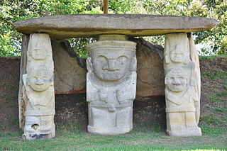
The San Agustín Archaeological Park, located on the Department of Huila, is the only place in the world highlighted by 500 imposing stone statues carved in accordance to the mythology of their Indian sculptors. Most of the statues were part of the funerary paraphernalia of the ancient inhabitants of the area and were related to funerary rites, the spiritual power of the dead, and the supernatural world. The monumental character of the stone statues and the tombs is a reflection of the complex thought system these unknown cultures carved and immortalized in stone. [www.colombia.travel] |
| Data | |
| Font | The San Agustín Archaeological Park |
| Autor | Jorge Láscar from Australia |
| Posició de la càmera | | Aquesta i altres imatges properes a: OpenStreetMap |
|---|
.jpg¶ms=001.916620_N_-076.243300_E_globe:Earth_type:camera_source:Flickr_&language=ca)
Llicència
Aquest fitxer està disponible sota la llicència Creative Commons Reconeixement 2.0 Genèrica.
- Sou lliure de:
- compartir – copiar, distribuir i comunicar públicament l'obra
- adaptar – fer-ne obres derivades
- Amb les condicions següents:
- reconeixement – Heu de donar la informació adequada sobre l'autor, proporcionar un enllaç a la llicència i indicar si s'han realitzat canvis. Podeu fer-ho amb qualsevol mitjà raonable, però de cap manera no suggereixi que l'autor us dóna suport o aprova l'ús que en feu.
| This image was originally posted to Flickr by Jorge Lascar at https://www.flickr.com/photos/8721758@N06/4925664602. It was reviewed on 2 d'abril de 2014 by FlickreviewR and was confirmed to be licensed under the terms of the cc-by-2.0. |

|
Les categories d'aquesta imatge han de ser corroborades. Feu-ho ara!
|
.jpg&action=edit&withJS=MediaWiki:Catcheck.js)
Historial del fitxer
Cliqueu una data/hora per veure el fitxer tal com era aleshores.
| Data/hora | Miniatura | Dimensions | Usuari/a | Comentari | |
|---|---|---|---|---|---|
| actual | 09:47, 2 abr 2014 | | 4.288 × 2.848 (3,03 Mo) | Russavia | Transferred from Flickr |
Ús del fitxer
La pàgina següent utilitza aquest fitxer:
Ús global del fitxer
Utilització d'aquest fitxer en altres wikis:
- Utilització a en.wikipedia.org
- Utilització a es.wikipedia.org
- Utilització a gl.wikipedia.org
.jpg)