
Fitxer:Toul Musée Saint Mansuy 02.jpg

Fitxer original (2.736 × 3.648 píxels, mida del fitxer: 4,38 Mo, tipus MIME: image/jpeg)
| Aquest fitxer i la informació mostrada a continuació provenen del dipòsit multimèdia lliure Wikimedia Commons. |
Resum
| Descripció |
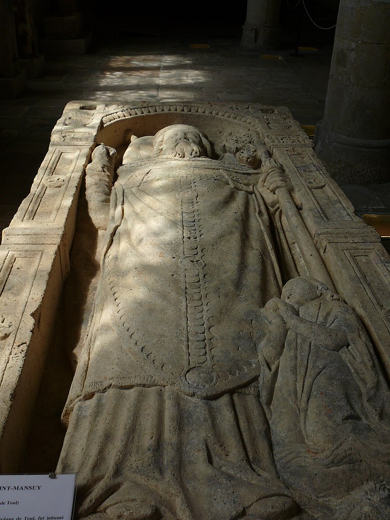
Nederlands: Grafmonument van St-Mansuy (2de helft van de vierde eeuw), de eerste bischop van Toul in in het Musée d'Art et d'Histoire de Toul.
St Mansuy werd begraven in de necropolis aan de weg naar Metz, ten noorden van de stad. Op die plaats werd een gebedsplaats en later een benedictijnerabdij opgericht. Dit kalkstenen monument werd gekapt in het eerste deel van de zestiende eeuw. Men ziet een liggende prelaat met de kentekens van een zestiende eeuwse bisschop: mijter en kruis en een surhuméral een kledingstuk typisch voor de bisschoppen van Toul. Aan zijn voeten zit een leeuw, kenmerkend voor waakzaamheid. Het knielend kind, dat iets ronds vasthoudt, verwijst naar het mirakel van het verdronken kind.English: Funerary monument of Saint Mansuy (second half of 4th century), the first bishop of Toul in the Musée d'Art et d'Histoire de Toul. Saint Mansuy was interred in the necropolis bordering the ancient road to Metz, north of Toul. First an oratory, later a benedictine abbey was erected at this site.
This limestone monument was carved at the beginning of the 16th century, it shows a lying prelate, dressed in the pontifical ornaments of the bishops of toul of the era. He wears a mitre and a cross and a ‘’surhuméral’’ (a small piece of clothing typical for the Toul diocese). His feet rest on a lion, symbol of vigilance. The little kneeling figure at his feet, holding a round object, reminds one of the miracle of the drowned child. |
| Data | |
| Font | Treball propi |
| Autor | Ad Meskens |
| Permís (Com reutilitzar aquest fitxer) |
You are free to use this picture for any purpose as long as you credit its author, Ad Meskens. Example: © Ad Meskens / Wikimedia Commons
This file has been released under a license which is incompatible with Facebook's licensing terms. It is not permitted to upload this file to Facebook.
|

| Posició de la càmera | | Aquesta i altres imatges properes a: OpenStreetMap |
|---|
Aquest object està catalogat monument històric
a la basa de dades Palissy per al patrimoni mobiliari del Ministeri de Cultura francès, amb la referència PM54000878.
|
Llicència
- Sou lliure de:
- compartir – copiar, distribuir i comunicar públicament l'obra
- adaptar – fer-ne obres derivades
- Amb les condicions següents:
- reconeixement – Heu de donar la informació adequada sobre l'autor, proporcionar un enllaç a la llicència i indicar si s'han realitzat canvis. Podeu fer-ho amb qualsevol mitjà raonable, però de cap manera no suggereixi que l'autor us dóna suport o aprova l'ús que en feu.
- compartir igual – Si modifiqueu, transformeu, o generareu amb el material, haureu de distribuir les vostres contribucions sota una llicència similar o una de compatible com l'original
Historial del fitxer
Cliqueu una data/hora per veure el fitxer tal com era aleshores.
| Data/hora | Miniatura | Dimensions | Usuari/a | Comentari | |
|---|---|---|---|---|---|
| actual | 20:34, 12 set 2011 | | 2.736 × 3.648 (4,38 Mo) | Ad Meskens |
Ús del fitxer
La pàgina següent utilitza aquest fitxer:
Ús global del fitxer
Utilització d'aquest fitxer en altres wikis:
- Utilització a fr.wikipedia.org