
Fitxer:United Kingdom EU referendum 2016 voting regions results.svg

Mida d'aquesta previsualització PNG del fitxer SVG: 388 × 600 píxels. Altres resolucions: 155 × 240 píxels | 310 × 480 píxels | 497 × 768 píxels | 663 × 1.024 píxels | 1.325 × 2.048 píxels | 886 × 1.369 píxels.
Fitxer original (fitxer SVG, nominalment 886 × 1.369 píxels, mida del fitxer: 2,67 Mo)
| Aquest fitxer i la informació mostrada a continuació provenen del dipòsit multimèdia lliure Wikimedia Commons. |
Resum
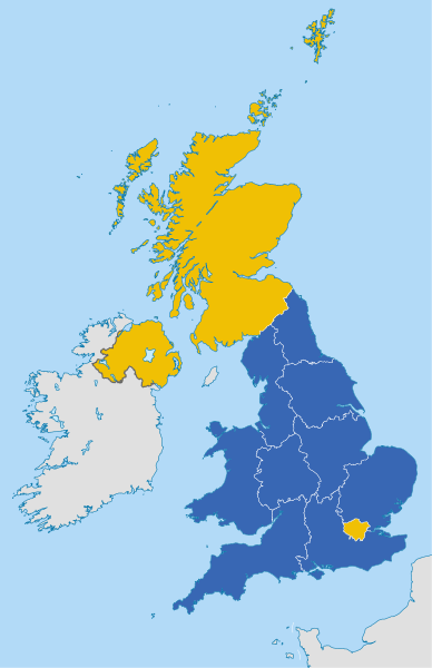
| Descripció |
English: Map of the United Kingdom showing the regional counting areas for the European Union membership referendum, 2016.
Remain
Leave Deutsch: Karte des Vereinigten Königreichs mit den Ergebnissen des Referendums über den Verbleib des Vereinigten Königreichs in der Europäischen Union 2016.
Verbleib in der EU
Ausscheiden aus der EU |
||
| Data | |||
| Font |
This file was derived from: United Kingdom NUTS location map.svg |
||
| Autor |
|
||
| Permís (Com reutilitzar aquest fitxer) |
Jo, el titular dels drets d'autor d'aquest treball, el public sota les següents llicències:
This file is licensed under the Creative Commons Attribution-Share Alike 4.0 International license.
Podeu seleccionar la llicència que vulgueu. |
||
| Altres versions |
 |
||
| SVG genesis | Aquesta imatge vectorial ha estat creada amb Adobe Illustrator, and with Inkscape. |

Historial del fitxer
Cliqueu una data/hora per veure el fitxer tal com era aleshores.
| Data/hora | Miniatura | Dimensions | Usuari/a | Comentari | |
|---|---|---|---|---|---|
| actual | 08:03, 14 ago 2017 | | 886 × 1.369 (2,67 Mo) | BurritoBazooka | tweak sea fill so that it is the same as another map frequently used with this one: File:United Kingdom EU referendum 2016 area results 2-tone.svg |
| 13:17, 24 juny 2016 |  | 886 × 1.369 (2,43 Mo) | Furfur | region's borders white | |
| 13:11, 24 juny 2016 |  | 886 × 1.369 (2,34 Mo) | Furfur | =={{int:filedesc}}== {{Information |description={{en|1=Map of the United Kingdom showing the regional counting areas for the European Union membership referendum, 2016.}} |date=2016-02-20 |source={{Derived from|United Kingdom NUTS location map.svg}} |a... |
Ús del fitxer
La pàgina següent utilitza aquest fitxer:
Ús global del fitxer
Utilització d'aquest fitxer en altres wikis:
- Utilització a ar.wikipedia.org
- Utilització a br.wikipedia.org
- Utilització a cy.wikipedia.org
- Utilització a de.wikipedia.org
- Utilització a en.wikipedia.org
- Utilització a es.wikipedia.org
- Utilització a fr.wikipedia.org
- Utilització a id.wikipedia.org
- Utilització a ja.wikipedia.org
- Utilització a ko.wikipedia.org
- Utilització a no.wikipedia.org
- Utilització a pl.wikipedia.org
- Utilització a pt.wikipedia.org
- Utilització a th.wikipedia.org
- Utilització a zh.wikipedia.org