
Fitxer:Yemen division 2011-10-23.svg

Mida d'aquesta previsualització PNG del fitxer SVG: 800 × 522 píxels. Altres resolucions: 320 × 209 píxels | 640 × 418 píxels | 1.024 × 669 píxels | 1.280 × 836 píxels | 2.560 × 1.671 píxels | 1.524 × 995 píxels.
Fitxer original (fitxer SVG, nominalment 1.524 × 995 píxels, mida del fitxer: 1,07 Mo)
| Aquest fitxer i la informació mostrada a continuació provenen del dipòsit multimèdia lliure Wikimedia Commons. |
Resum
| Descripció |
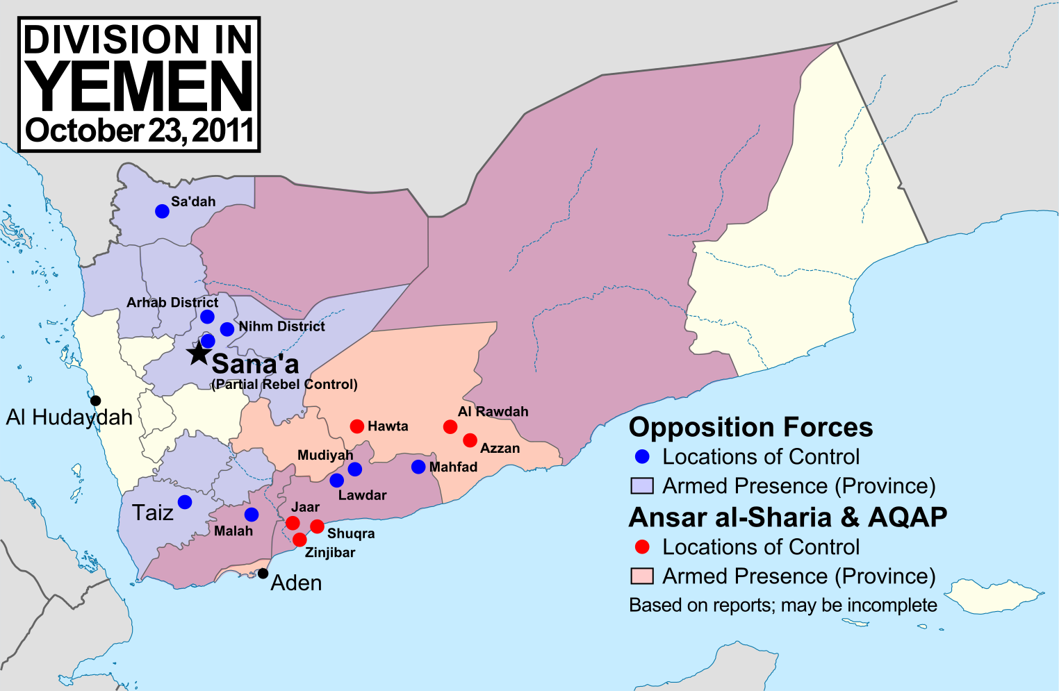
English: Note: This map depicts the situation in October 2011. For an updated version, see File:Yemen division 2012-3-11.svg. Map of division in Yemen as of October 23, 2011. Map is limited to information from English-language media, and therefore may be incomplete. Red represents Islamist extremists under Ansar al-Sharia and/or Al-Qaeda in the Arabian Peninsula (AQAP). Blue represents all other non-government armed groups which are hostile or possibly hostile to the government of President Ali Abdullah Saleh, including military defectors, pre-existing rebel groups, and local and kinship-based militias (including those which have worked together with the government against Ansar al-Sharia). Dots indicate specific locations cited by the media as being currently controlled by said groups, while shading indicates provinces (governorates) from which an open armed presence or attacks by said groups have been reported since the uprising began. Purple shading indicates that Ansar al-Sharia/AQAP and other non-government forces both have armed presences reported within the province, while white indicates that no rebel activity has been reported (implying that Saleh's government still fully maintains state power there). Note that unarmed protests are not depicted, and would extend well into the white areas of the map. See also: File:Yemen division 2011-7-7.svg |
| Data | |
| Font | Treball propi, starting from File:Yemen_location_map.svg by user NordNordWest. Information comes from a variety of online news sources, especially the Yemen Post and Critical Threats. |
| Autor | GeoEvan |
| Permís (Com reutilitzar aquest fitxer) |
Modified version of file from Political Geography Now blog, re-licensed here to allow for commercial use. Please credit "Political Geography Now" with link to http://www.polgeonow.com. |
Llicència
Jo, el titular dels drets d'autor d'aquest treball, el public sota la següent llicència:
Aquest fitxer està subjecte a la llicència de Creative Commons Reconeixement i Compartir Igual 3.0 No adaptada.
- Sou lliure de:
- compartir – copiar, distribuir i comunicar públicament l'obra
- adaptar – fer-ne obres derivades
- Amb les condicions següents:
- reconeixement – Heu de donar la informació adequada sobre l'autor, proporcionar un enllaç a la llicència i indicar si s'han realitzat canvis. Podeu fer-ho amb qualsevol mitjà raonable, però de cap manera no suggereixi que l'autor us dóna suport o aprova l'ús que en feu.
- compartir igual – Si modifiqueu, transformeu, o generareu amb el material, haureu de distribuir les vostres contribucions sota una llicència similar o una de compatible com l'original
Historial del fitxer
Cliqueu una data/hora per veure el fitxer tal com era aleshores.
| Data/hora | Miniatura | Dimensions | Usuari/a | Comentari | |
|---|---|---|---|---|---|
| actual | 17:15, 19 nov 2011 | | 1.524 × 995 (1,07 Mo) | GeoEvan | Corrections per English Wikipedia talk page (http://en.wikipedia.org/wiki/File_talk:Yemen_division_2011-10-23.svg): Added Sa'dah city to opposition controlled locations; changed "Islamist Militants" label to "Ansar a-Sharia & AQAP" so as to exclude the un |
| 21:41, 25 oct 2011 |  | 1.524 × 995 (1,04 Mo) | GeoEvan | =={{int:filedesc}}== {{Information |description={{en|1=Map of division in Yemen as of October 23, 2011. Map is limited to information from from English-language media, and therefore may be incomplete. Red represents Islamist militants (Ansar al-Sharia and |
Ús del fitxer
Les 2 pàgines següents utilitzen aquest fitxer:
Ús global del fitxer
Utilització d'aquest fitxer en altres wikis:
- Utilització a azb.wikipedia.org
- Utilització a en.wikipedia.org
- Utilització a hy.wikipedia.org
- Utilització a it.wikipedia.org
- Utilització a ka.wikipedia.org
- Utilització a pl.wikipedia.org
- Utilització a pt.wikipedia.org
- Utilització a ru.wikipedia.org
- Utilització a www.wikidata.org