Fitxer:America noviter delineata.jpg
El contingut de la pàgina no s'admet en altres llengües.
De la Viquipèdia, l'enciclopèdia lliure

Fitxer original(5.965 × 4.528 píxels, mida del fitxer: 5,17 Mo, tipus MIME: image/jpeg)

Descripció a Commons

Resum

Descripció
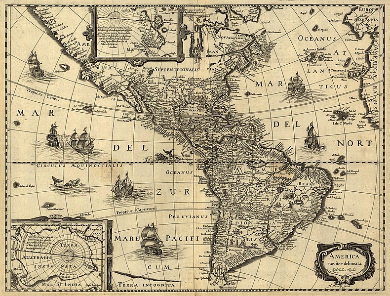
Latina: America noviter delineata / auct. Jodoco Hondio; H. Picard fecit.
English: America newly delineated / by Jodocus Hondius; engraved by H. Picard. A 17th-century map of the Americas. Scale ca. 1:45,000,000. Map ranges from W 125°–W 5° and N 70°–S 60°. Also includes insets of the polar regions.
Français : L'amérique nouvellement cartographiée / Par Jocodus Hondius; gravé par H. Picard. Une carte des amériques du XVIIe siècle. Echelle: environ 1:45 000 000. La carte couvre un espace allant de 5°W à 125°W et de 60°S à 70°N. Elle inclut aussi en encarts les régions polaires.
Font

Published by Jean Boisseau. The U.S. Library of Congress gives the date of publication as "1640?", while another source suggests a first publication of 1637 or 1639. Digital version produced by the U.S. Library of Congress Geography and Map Division. JPEG 2000 source image converted to JPEG by User:Delirium using JasPer 1.701.0, since JPEG 2000 is not as of this uploading supported on Commons.

This map is available from the United States Library of Congress's Geography & Map Division
under the digital ID g3290.np000144.
This tag does not indicate the copyright status of the attached work. A normal copyright tag is still required. See Commons:Licensing.

العربية  беларуская (тарашкевіца)  বাংলা  čeština  Deutsch  English  español  فارسی  suomi  français  galego  עברית  magyar  Bahasa Indonesia  italiano  日本語  lietuvių  македонски  മലയാളം  Nederlands  polski  português  português do Brasil  română  русский  sicilianu  slovenčina  slovenščina  Türkçe  українська  简体中文  繁體中文  +/−

Creador
Jodocus Hondius (1563-1612)
Permís
(Com reutilitzar aquest fitxer)
Això és una mera fotografia d'una obra d'art bidimensional en domini públic. L'obra d'art original és en domini públic pel següent motiu:
Public domain

Aquest material està en domini públic als Estats Units i als altres països on el dret d'autor s'estén per 100 anys (o menys) després de la mort de l'autor.


Cal incloure una etiqueta de domini públic als Estats Units per indicar perquè aquesta obra és en domini públic als Estats Units.
La posició oficial de la Fundació Wikimedia és que «les reproduccions fidels d'obres d'art bidimensionals de domini públic són en domini públic».
Per tant, aquesta reproducció fotogràfica també es considera en domini públic als Estats Units. En altres jurisdiccions la reutilització d'aquest contingut pot estar restringida; vegeu Reuse of PD-Art photographs per a més informació.
Georeferencing Georeference the map in Wikimaps Warper If inappropriate please set warp_status = skip to hide.


Awards

Imatge of the year
Imatge of the year
Imatge of the day
Imatge of the day
Featured imatge

Wikimedia Commons

Aquesta imatge ha estat candidata a Imatge de l'any 2006.
Aquesta imatge va ser la Imatge del dia el 17 abril 2007.
Aquest és un arxiu d'imatge destacat a Wikimedia Commons (Imatges destacades) i és considerat un dels més acurats arxius d'imatge.
 Pel seu format de 4:3 o 5:4 aquesta imatge és adequada com a fons de pantalla.

Si teniu una imatge de qualitat similar que es pot publicar sota una llicència de copyright adient, animeu-vos a carregar-la, identificar-la i nominar-la.

Llegendes

Afegeix una explicació d'una línia del que representa aquest fitxer
A 17th-century map of the Americas newly delineated by Jodocus Hondius; engraved by H. Picard.

Elements representats en aquest fitxer

representa l'entitat

5.422.959 byte

4.528 píxel

5.965 píxel

Historial del fitxer

Cliqueu una data/hora per veure el fitxer tal com era aleshores.

Data/horaMiniaturaDimensionsUsuari/aComentari
actual08:33, 14 juny 2006Miniatura per a la versió del 08:33, 14 juny 20065.965 × 4.528 (5,17 Mo)Delirium''America noviter delineata / auct. Jodoco Hondio; H. Picard fecit.'' (America newly delineated / by Jodoco Hondia; engraved by H. Picard.) A 17th-century map of the Americas. Scale ca. 1:45,000,000. Map ranges from W 125°–W 5° and N 70&d

Ús global del fitxer

Utilització d'aquest fitxer en altres wikis:

Vegeu més usos globals d'aquest fitxer.

Metadades