
Fitxer:Buyids within the Middle East, ca. 970.png
Mida d'aquesta previsualització: 800 × 453 píxels. Altres resolucions: 320 × 181 píxels | 640 × 362 píxels | 1.202 × 680 píxels.
Fitxer original (1.202 × 680 píxels, mida del fitxer: 359 Ko, tipus MIME: image/png)
| Aquest fitxer i la informació mostrada a continuació provenen del dipòsit multimèdia lliure Wikimedia Commons. |
Resum
| Descripció |
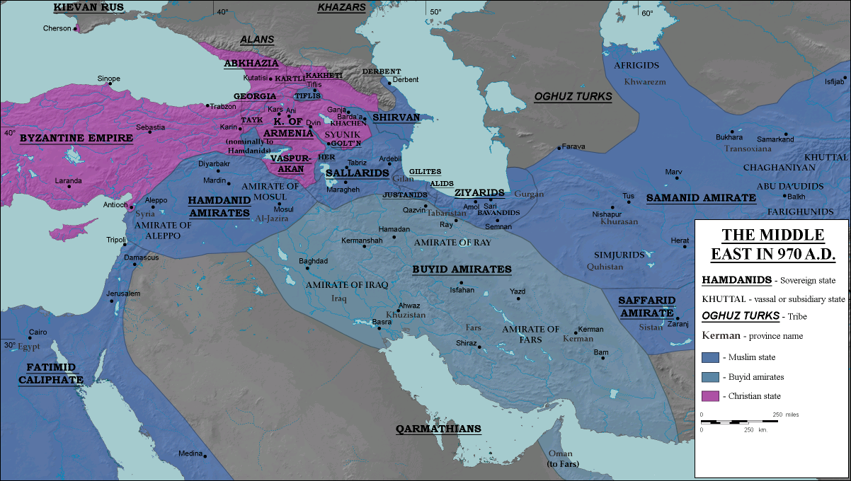
English: The domains of the Buyid dynasty highlighted among other Muslim (blue) and eastern Christian (purple) states, ca. 970 CE |
| Data | |
| Font |
Transferred from en.wikipedia to Commons.
|
| Autor | ro4444 |
| Permís (Com reutilitzar aquest fitxer) |
. Original uploader was Ro4444 at en.wikipedia CC-BY-SA-3.0; Released under the GNU Free Documentation License. |
| Altres versions |
|

Llicència
Ro4444 de la Viquipèdia en anglès, el titular dels drets d'autor d'aquest treball, el public sota les següents llicències:
Aquest fitxer està subjecte a la llicència de Creative Commons Reconeixement i Compartir Igual 3.0 No adaptada.
Reconeixement: Ro4444 de la Viquipèdia en anglès
- Sou lliure de:
- compartir – copiar, distribuir i comunicar públicament l'obra
- adaptar – fer-ne obres derivades
- Amb les condicions següents:
- reconeixement – Heu de donar la informació adequada sobre l'autor, proporcionar un enllaç a la llicència i indicar si s'han realitzat canvis. Podeu fer-ho amb qualsevol mitjà raonable, però de cap manera no suggereixi que l'autor us dóna suport o aprova l'ús que en feu.
- compartir igual – Si modifiqueu, transformeu, o generareu amb el material, haureu de distribuir les vostres contribucions sota una llicència similar o una de compatible com l'original

|
S'autoritza la còpia, la distribució i la modificació d'aquest document sota els termes de la llicència de documentació lliure GNU versió 1.2 o qualsevol altra versió posterior que publiqui la Free Software Foundation; sense seccions invariants, ni textos de portada, ni textos de contraportada. S'inclou una còpia d'aquesta llicència en la secció titulada GNU Free Documentation License. |
Podeu seleccionar la llicència que vulgueu.
Registre original de càrregues
La pàgina de descripció original era aquí. Els noms d'usuari a continuació es refereixen a en.wikipedia.
- 2008-07-05 16:20 Ro4444 1202×680× (368060 bytes) == Description == {{Information |Description= {{en| Political map in English of the Middle East in 970 A.D.}} |Source=Own work. {{clr}} Data sources : * Background map : [[http://en.wikipedia.org/wiki/Topographic_map#Global_1-kilometer_map]] (SRTM3 v.2) (
- 2008-06-29 04:51 Ro4444 1202×680× (368939 bytes) == Summary == == Description == {{Information |Description= {{en| Political map in English of the Middle East in 970 A.D.}} |Source=Own work. {{clr}} Data sources : * Background map : [[http://en.wikipedia.org/wiki/Topographic_map#Global_1-kilometer_map]]
- 2008-06-27 21:24 Ro4444 1202×680× (369445 bytes) == Summary == == Description == {{Information |Description= {{en| Political map in English of the Middle East in 970 A.D.}} |Source=Own work. {{clr}} Data sources : * Background map : [[http://en.wikipedia.org/wiki/Topographic_map#Global_1-kilometer_map]]
- 2008-06-27 17:30 Ro4444 1202×680× (369418 bytes) == Description == {{Information |Description= {{en| Political map in English of the Middle East in 970 A.D.}} |Source=Own work. {{clr}} Data sources : * Background map : [[http://en.wikipedia.org/wiki/Topographic_map#Global_1-kilometer_map]] (SRTM3 v.2) (
Historial del fitxer
Cliqueu una data/hora per veure el fitxer tal com era aleshores.
| Data/hora | Miniatura | Dimensions | Usuari/a | Comentari | |
|---|---|---|---|---|---|
| actual | 16:55, 26 jul 2012 | | 1.202 × 680 (359 Ko) | OgreBot | (BOT): Reverting to most recent version before archival |
| 16:55, 26 jul 2012 |  | 1.202 × 680 (360 Ko) | OgreBot | (BOT): Uploading old version of file from en.wikipedia; originally uploaded on 2008-06-29 04:51:30 by Ro4444 | |
| 16:55, 26 jul 2012 |  | 1.202 × 680 (361 Ko) | OgreBot | (BOT): Uploading old version of file from en.wikipedia; originally uploaded on 2008-06-27 21:24:54 by Ro4444 | |
| 16:55, 26 jul 2012 |  | 1.202 × 680 (361 Ko) | OgreBot | (BOT): Uploading old version of file from en.wikipedia; originally uploaded on 2008-06-27 17:30:29 by Ro4444 | |
| 17:34, 25 jul 2012 |  | 1.202 × 680 (359 Ko) | Cplakidas | {{Information |Description={{en|The domains of the en:Buyid dynasty highlighted among other Muslim (blue) and eastern Christian (purple) states, ca. 970 CE}} |Source=Transferred from [http://en.wikipedia.org en.wikipedia]<br/> (Original text : ''... |
Ús del fitxer
La pàgina següent utilitza aquest fitxer:
Ús global del fitxer
Utilització d'aquest fitxer en altres wikis:
- Utilització a ar.wikipedia.org
- Utilització a av.wikipedia.org
- Utilització a bg.wikipedia.org
- Utilització a de.wikipedia.org
- Utilització a de.wikiversity.org
- Utilització a el.wikipedia.org
- Utilització a en.wikipedia.org
- Utilització a en.wikibooks.org
- Utilització a es.wikipedia.org
- Utilització a fa.wikipedia.org
- Utilització a fi.wikipedia.org
- Utilització a he.wikipedia.org
- Utilització a it.wikipedia.org
- Utilització a ja.wikipedia.org
- Utilització a ku.wikipedia.org
- Utilització a nl.wikipedia.org
- Utilització a pnb.wikipedia.org
- Utilització a pt.wikipedia.org
- Utilització a ru.wikipedia.org
- Utilització a tg.wikipedia.org
- Utilització a uz.wikipedia.org
- Utilització a zh.wikipedia.org