
Fitxer:Canada2.A2002165.1940.250m.jpg

Mida d'aquesta previsualització: 461 × 599 píxels. Altres resolucions: 184 × 240 píxels | 369 × 480 píxels | 591 × 768 píxels | 788 × 1.024 píxels | 1.575 × 2.048 píxels | 4.000 × 5.200 píxels.
Fitxer original (4.000 × 5.200 píxels, mida del fitxer: 2,83 Mo, tipus MIME: image/jpeg)
| Aquest fitxer i la informació mostrada a continuació provenen del dipòsit multimèdia lliure Wikimedia Commons. |
Resum
| Descripció |
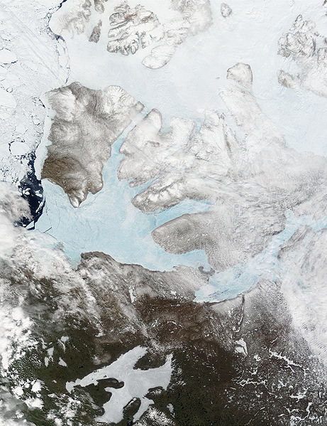
English: These Moderate resolution Imaging Spectroradiometer Images from June 14 and 16, 2002, show Banks Island (upper left) and Victoria Island (to the southeast) in the Arctic Ocean off northwest Canada. Left of center in each image is Amundsen Gulf, looking bright blue as this arm of the Beaufort Sea (at the southern end of the Arctic Ocean) begins to thaw. At the bottom of the images, the tundra of the Northwest Territories (left) and the Nunavut (right) Provinces of Canada is beginning to lose its winter snow cover. At bottom center of the portrait oriented image is Great Bear lake--still frozen. |
| Data | June 14 and 16, 2002 |
| Font | http://visibleearth.nasa.gov/view_rec.php?id=3342 |
| Autor | Jacques Descloitres, MODIS Land Rapid Response Team, NASA/GSFC |
Llicència
| Aquest fitxer és en el domini públic perquè ha estat creat per la NASA. L'avís legal de la NASA diu que «el material de la NASA no està protegit per copyright si no es diu el contrari». (NASA copyright policy page o JPL Image Use Policy). | ||
 |
Atenció:
|
Historial del fitxer
Cliqueu una data/hora per veure el fitxer tal com era aleshores.
| Data/hora | Miniatura | Dimensions | Usuari/a | Comentari | |
|---|---|---|---|---|---|
| actual | 19:59, 20 ago 2008 | | 4.000 × 5.200 (2,83 Mo) | Ando228 | {{Information |Description={{en|1=These Moderate resolution Imaging Spectroradiometer Images from June 14 and 16, 2002, show Banks Island (upper left) and Victoria Island (to the southeast) in the Arctic Ocean off northwest Canada. Left of center in each |
Ús del fitxer
Les 3 pàgines següents utilitzen aquest fitxer:
Ús global del fitxer
Utilització d'aquest fitxer en altres wikis:
- Utilització a af.wikipedia.org
- Utilització a ar.wikipedia.org
- Utilització a ast.wikipedia.org
- Utilització a az.wikipedia.org
- Utilització a be.wikipedia.org
- Utilització a bg.wikipedia.org
- Utilització a bn.wikipedia.org
- Utilització a ceb.wikipedia.org
- Utilització a cy.wikipedia.org
- Utilització a da.wikipedia.org
- Utilització a de.wikivoyage.org
- Utilització a diq.wikipedia.org
- Utilització a en.wikipedia.org
- Utilització a es.wikipedia.org
- Utilització a eu.wikipedia.org
- Utilització a fa.wikipedia.org
- Utilització a fi.wikipedia.org
- Utilització a fr.wikipedia.org
- Utilització a fr.wikivoyage.org
- Utilització a fy.wikipedia.org
- Utilització a ga.wikipedia.org
- Utilització a gl.wikipedia.org
- Utilització a he.wikipedia.org
- Utilització a hu.wikipedia.org
- Utilització a hy.wikipedia.org
- Utilització a ilo.wikipedia.org
- Utilització a is.wikipedia.org
- Utilització a it.wikipedia.org
- Utilització a ja.wikipedia.org
- Utilització a ko.wikipedia.org
- Utilització a ku.wikipedia.org
- Utilització a la.wikipedia.org
- Utilització a lv.wikipedia.org
- Utilització a ml.wikipedia.org
- Utilització a mzn.wikipedia.org
- Utilització a nl.wikipedia.org
- Utilització a nn.wikipedia.org
- Utilització a no.wikipedia.org
- Utilització a os.wikipedia.org
- Utilització a pl.wikipedia.org
Vegeu més usos globals d'aquest fitxer.