
Fitxer:Debra 1959 track.png

Mida d'aquesta previsualització: 800 × 494 píxels. Altres resolucions: 320 × 198 píxels | 640 × 396 píxels | 1.024 × 633 píxels | 1.280 × 791 píxels | 3.000 × 1.854 píxels.
Fitxer original (3.000 × 1.854 píxels, mida del fitxer: 7,33 Mo, tipus MIME: image/png)
| Aquest fitxer i la informació mostrada a continuació provenen del dipòsit multimèdia lliure Wikimedia Commons. |
| Descripció |
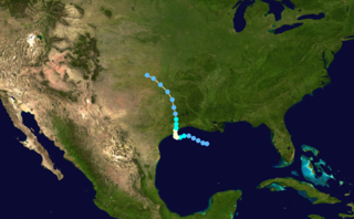
English: Track map of Hurricane Debra of the 1959 Atlantic hurricane season. The points show the location of the storm at 6-hour intervals. The colour represents the storm's maximum sustained wind speeds as classified in the Saffir-Simpson Hurricane Scale (see below), and the shape of the data points represent the nature of the storm, according to the legend below.
Tropical depression (≤38 mph, ≤62 km/h)
Tropical storm (39–73 mph, 63–118 km/h)
Category 1 (74–95 mph, 119–153 km/h)
Category 2 (96–110 mph, 154–177 km/h)
Category 3 (111–129 mph, 178–208 km/h)
Category 4 (130–156 mph, 209–251 km/h)
Category 5 (≥157 mph, ≥252 km/h)
Unknown
Storm type |
||
| Data | |||
| Font | Created using Wikipedia:WikiProject Tropical cyclones/Tracks. The background image is from NASA. Tracking data is from the HURDAT database. | ||
| Autor | Niflanion | ||
| Permís (Com reutilitzar aquest fitxer) |
|
Historial del fitxer
Cliqueu una data/hora per veure el fitxer tal com era aleshores.
| Data/hora | Miniatura | Dimensions | Usuari/a | Comentari | |
|---|---|---|---|---|---|
| actual | 21:37, 14 jul 2016 | | 3.000 × 1.854 (7,33 Mo) | Cyclonebiskit | Reanalysis update |
| 23:00, 13 jul 2006 |  | 1.024 × 633 (921 Ko) | Nilfanion | ||
| 03:08, 2 feb 2006 |  | 1.024 × 633 (921 Ko) | Jdorje~commonswiki | {{Hurricane auto track map|Hurricane Debra (1959)}} |
Ús del fitxer
La pàgina següent utilitza aquest fitxer:
Ús global del fitxer
Utilització d'aquest fitxer en altres wikis:
- Utilització a en.wikipedia.org
- Utilització a pt.wikipedia.org