
Fitxer:Dené-Yeniseian.svg

Mida d'aquesta previsualització PNG del fitxer SVG: 800 × 465 píxels. Altres resolucions: 320 × 186 píxels | 640 × 372 píxels | 1.024 × 595 píxels | 1.280 × 744 píxels | 2.560 × 1.489 píxels | 951 × 553 píxels.
Fitxer original (fitxer SVG, nominalment 951 × 553 píxels, mida del fitxer: 608 Ko)
| Aquest fitxer i la informació mostrada a continuació provenen del dipòsit multimèdia lliure Wikimedia Commons. |
| Descripció |
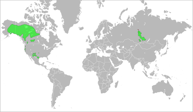
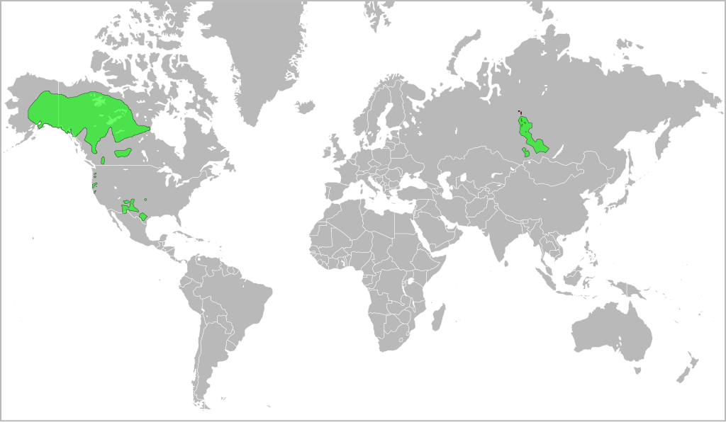
English: A map indicating the approximate distribution of the Dené-Yeniseian languages (green areas) in the XVII century. |
| Data | (UTC) |
| Font | |
| Autor |
|
Aquest fitxer està subjecte a la llicència de Creative Commons Reconeixement i Compartir Igual 3.0 No adaptada.
- Sou lliure de:
- compartir – copiar, distribuir i comunicar públicament l'obra
- adaptar – fer-ne obres derivades
- Amb les condicions següents:
- reconeixement – Heu de donar la informació adequada sobre l'autor, proporcionar un enllaç a la llicència i indicar si s'han realitzat canvis. Podeu fer-ho amb qualsevol mitjà raonable, però de cap manera no suggereixi que l'autor us dóna suport o aprova l'ús que en feu.
- compartir igual – Si modifiqueu, transformeu, o generareu amb el material, haureu de distribuir les vostres contribucions sota una llicència similar o una de compatible com l'original
Registre original de càrregues
This image is a derivative work of the following images:
- File:Yeniseian_map_XVII-XX.png licensed with Cc-by-2.5
- 2009-01-19T22:38:12Z 姫宮南 450x500 (31768 Bytes) {{Information |Description={{en|The map of distribution of [[:en:Yeniseian languages|]] (red) in the XVII century (approximate; hatching) and in the end of XX century (continuous background).}}{{ru|Карта распрос�
- File:Na-Dene_langs.png licensed with Cc-by-2.0
Uploaded with derivativeFX
Historial del fitxer
Cliqueu una data/hora per veure el fitxer tal com era aleshores.
| Data/hora | Miniatura | Dimensions | Usuari/a | Comentari | |
|---|---|---|---|---|---|
| actual | 16:17, 25 nov 2016 | | 951 × 553 (608 Ko) | Elevatorrailfan | No need not to include the borders of Europe. |
| 18:13, 24 maig 2010 |  | 951 × 553 (548 Ko) | Jon Harald Søby | Fixing background issues, removing whitespace | |
| 01:59, 3 març 2010 |  | 999 × 553 (636 Ko) | Ryanaxp | Made all areas green, instead of green and red, to improve clarity | |
| 01:52, 3 març 2010 |  | 999 × 553 (556 Ko) | Ryanaxp | {{Information |Description={{en|A map indicating the approximate distribution of the Dené-Yeniseian languages (red and green areas) in the XVII century.}} |Source=*File:Yeniseian_map_XVII-XX.png *[[:File:Na-Dene_la |
Ús del fitxer
Les 4 pàgines següents utilitzen aquest fitxer:
Ús global del fitxer
Utilització d'aquest fitxer en altres wikis:
- Utilització a af.wikipedia.org
- Utilització a ast.wikipedia.org
- Utilització a el.wikipedia.org
- Utilització a en.wikipedia.org
- Utilització a es.wikipedia.org
- Utilització a fi.wikipedia.org
- Utilització a frr.wikipedia.org
- Utilització a fr.wikipedia.org
- Utilització a fy.wikipedia.org
- Utilització a ja.wikipedia.org
- Utilització a lez.wikipedia.org
- Utilització a lt.wikipedia.org
- Utilització a mg.wikipedia.org
- Utilització a mrj.wikipedia.org
- Utilització a nl.wikipedia.org
- Utilització a no.wikipedia.org
- Utilització a pl.wikipedia.org
- Utilització a sr.wikipedia.org
- Utilització a tr.wikipedia.org
- Utilització a ur.wikipedia.org
- Utilització a zh.wikipedia.org