
Fitxer:Derbyshire UK location map.svg

Mida d'aquesta previsualització PNG del fitxer SVG: 406 × 599 píxels. Altres resolucions: 162 × 240 píxels | 325 × 480 píxels | 520 × 768 píxels | 693 × 1.024 píxels | 1.387 × 2.048 píxels | 884 × 1.305 píxels.
Fitxer original (fitxer SVG, nominalment 884 × 1.305 píxels, mida del fitxer: 2,38 Mo)
| Aquest fitxer i la informació mostrada a continuació provenen del dipòsit multimèdia lliure Wikimedia Commons. |
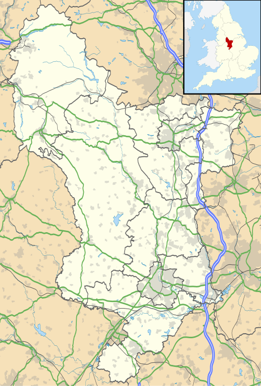
| Descripció |
Map of Derbyshire, UK with the following information shown:
Equirectangular map projection on WGS 84 datum, with N/S stretched 165% Geographic limits:
|
| Data | |
| Font |
|
| Autor | Nilfanion, created using Ordnance Survey data |
| Permís (Com reutilitzar aquest fitxer) |
Aquest fitxer està subjecte a la llicència de Creative Commons Reconeixement i Compartir Igual 3.0 No adaptada. Reconeixement: Contains Ordnance Survey data © Crown copyright and database right
|
| Altres versions | File:Devon UK district map (blank).svg - Blank map |
.svg)
Historial del fitxer
Cliqueu una data/hora per veure el fitxer tal com era aleshores.
| Data/hora | Miniatura | Dimensions | Usuari/a | Comentari | |
|---|---|---|---|---|---|
| actual | 20:46, 26 set 2010 | | 884 × 1.305 (2,38 Mo) | Nilfanion | {{Information |Description=Map of Derbyshire, UK with the following information shown: *Administrative borders *Coastline, lakes and rivers *Roads and railways *Urban areas Equirectangular map projection on WGS 84 datum, with N/S stretch |
Ús del fitxer
Les 3 pàgines següents utilitzen aquest fitxer:
Ús global del fitxer
Utilització d'aquest fitxer en altres wikis:
- Utilització a ar.wikipedia.org
- Utilització a bg.wikipedia.org
- Utilització a ceb.wikipedia.org
- Utilització a cs.wikipedia.org
- Utilització a cy.wikipedia.org
- Utilització a el.wikipedia.org
- Utilització a en.wikipedia.org
- Derbyshire
- Chatsworth House
- Kedleston Hall
- Staveley, Derbyshire
- Glossop
- Buxton
- Calke Abbey
- Sudbury Hall
- Bolsover Castle
- Chesterfield, Derbyshire
- Thornhill, Derbyshire
- Newhaven, Derbyshire
- Gamesley
- Bretby Hall
- Birchinlee
- Ripley, Derbyshire
- Repton
- Eyam
- Edale
- Castleton, Derbyshire
- Hope, Derbyshire
- Hathersage
- Spondon
- Matlock, Derbyshire
- Matlock Bath
- Bolsover
- Ashbourne, Derbyshire
- Alfreton
- Heanor
- Pleasley
- Wirksworth
- Leam, Derbyshire
- Ilkeston
- Heage
- New Mills
- Long Eaton
- Littleover
- Mickleover
- Dronfield
- Tideswell
- Hartington, Derbyshire
- Youlgreave
- Whatstandwell
- Monyash
Vegeu més usos globals d'aquest fitxer.