
Fitxer:Eyjafjallajökull volcanic ash 17 April 2010.png
No hi ha cap versió amb una resolució més gran.
Eyjafjallajökull_volcanic_ash_17_April_2010.png (680 × 520 píxels, mida del fitxer: 127 Ko, tipus MIME: image/png)
| Aquest fitxer i la informació mostrada a continuació provenen del dipòsit multimèdia lliure Wikimedia Commons. |

|
Aquesta imatge (de tipus geology) s'hauria de tornar a crear utilitzant gràfics vectorials com ara un fitxer SVG. Això té diversos avantatges; en trobareu més informació a Commons:Media for cleanup. Si ja disposeu d'una versió d'aquesta imatge en format SVG, us preguem que la pengeu; després, reemplaceu aquesta plantilla amb la plantilla {{Vector version available|nom nou de la imatge.svg}} en aquesta imatge.
|
| Descripció |
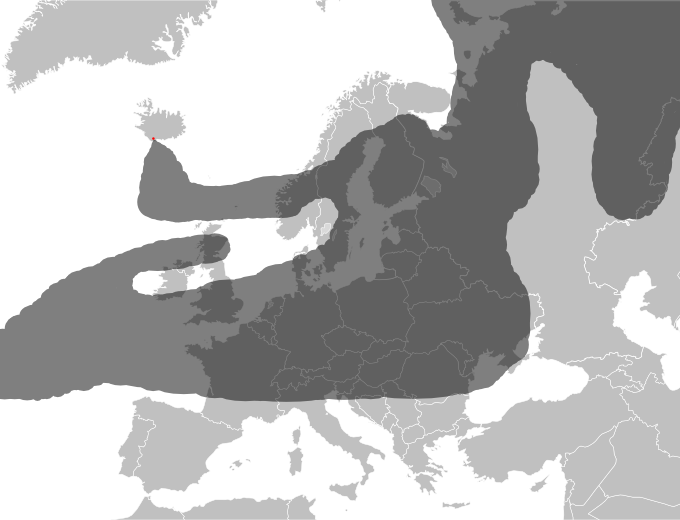
Approximate drawing of estimated ash cloud from the Eyjafjallajökull eruption as of 17 April 2010 at 18:00 UTC. Source: http://www.metoffice.gov.uk/aviation/vaac/data/VAG_1271527299.png Newer map: File:Eyjafjallajökull volcanic ash 19 April 2010.png Updates at http://www.metoffice.gov.uk/aviation/vaac/vaacuk_vag.html |
| Data | (UTC) |
| Font | |
| Autor |
|
| Això és una imatge retocada, cosa que vol dir que ha estat alterada digitalment de la seva versió original. Modificacions: drawed ash coverage. L'original es pot veure a: Blank map of Europe.svg:
|
Aquest fitxer està subjecte a la llicència de Creative Commons Reconeixement i Compartir Igual 3.0 No adaptada.
- Sou lliure de:
- compartir – copiar, distribuir i comunicar públicament l'obra
- adaptar – fer-ne obres derivades
- Amb les condicions següents:
- reconeixement – Heu de donar la informació adequada sobre l'autor, proporcionar un enllaç a la llicència i indicar si s'han realitzat canvis. Podeu fer-ho amb qualsevol mitjà raonable, però de cap manera no suggereixi que l'autor us dóna suport o aprova l'ús que en feu.
- compartir igual – Si modifiqueu, transformeu, o generareu amb el material, haureu de distribuir les vostres contribucions sota una llicència similar o una de compatible com l'original
Registre original de càrregues
This image is a derivative work of the following images:
- File:Blank_map_of_Europe.svg licensed with Cc-by-sa-2.5
- 2008-09-17T09:50:25Z F7 680x520 (531491 Bytes)
- 2008-09-17T09:42:57Z F7 680x520 (2353 Bytes)
- 2008-05-26T19:04:07Z Collard 680x520 (531491 Bytes) uploading on behalf of [[User:Checkit]], direct complaints to him plox: 'Moved countries out of the "outlines" group, removed "outlines" style class, remove separate style information for Russia'
- 2008-04-30T01:38:52Z TimothyBourke 680x520 (531767 Bytes) Changed the country code of Serbia to RS per [http://en.wikipedia.org/wiki/Serbian_country_codes] and the file [http://www.iso.org/iso/iso3166_en_code_lists.txt].
- 2008-02-08T22:44:37Z CarolSpears 680x520 (531767 Bytes) validated
- 2007-07-10T11:47:59Z MrWeeble 680x520 (533112 Bytes) Updated to include British Crown Dependencies as seperate entities and regroup them as "British Islands", with some simplifications to the XML and CSS
- 2007-05-14T17:17:34Z Zirland 680x520 (540659 Bytes) serbia and montenegro
- 2007-03-30T20:40:49Z W!B: 680x520 (538830 Bytes) minor corr: update nl:Ijsselmeer, del fi:lakes (all small), add ru:lake Oneka (all ref maps.google), glued northern irland back to ie ;)
- 2007-02-05T18:44:32Z Maix 680x520 (538295 Bytes) cropped
- 2007-02-04T15:07:29Z Maix 680x520 (538310 Bytes) {{Information |Description=A blank Map of Europe in SVG format. Every country has an id which is its ISO-3116-1-ALPHA2 code in lower case for easy coloring. |Source=Image based on [[Image:Europe_countries.svg|]] by [[User:Ti
Uploaded with derivativeFX
Historial del fitxer
Cliqueu una data/hora per veure el fitxer tal com era aleshores.
| Data/hora | Miniatura | Dimensions | Usuari/a | Comentari | |
|---|---|---|---|---|---|
| actual | 23:24, 17 abr 2010 | | 680 × 520 (127 Ko) | Hydrox | Enhanced approximation of the same source. |
| 22:01, 17 abr 2010 |  | 680 × 520 (127 Ko) | Hydrox | Updated to reflect the data as of April 17th, 18:00 UTC (http://www.metoffice.gov.uk/aviation/vaac/data/VAG_1271527299.png) | |
| 18:43, 16 abr 2010 |  | 680 × 520 (127 Ko) | Cogiati | {{Information |Description=Approximate drawing of estimated ash cloud from the Eyjafjallajökull eruption as of 17 April 2010 at 06:00 UTC. Source: http://www.metoffice.gov.uk/aviation/vaac/data/VAG_1271417376.png Updates at http://www.metoffice.gov.uk/a |
Ús del fitxer
Les 2 pàgines següents utilitzen aquest fitxer:
Ús global del fitxer
Utilització d'aquest fitxer en altres wikis:
- Utilització a an.wikipedia.org
- Utilització a arz.wikipedia.org
- Utilització a cs.wikipedia.org
- Utilització a da.wikipedia.org
- Utilització a de.wikipedia.org
- Utilització a de.wikinews.org
- Utilització a en.wikipedia.org
- Utilització a en.wikinews.org
- Utilització a eu.wikipedia.org
- Utilització a fi.wikipedia.org
- Utilització a fi.wikinews.org
- Utilització a he.wikipedia.org
- Utilització a hr.wikipedia.org
- Utilització a hu.wikipedia.org
- Utilització a hu.wikinews.org
- Utilització a id.wikipedia.org
- Utilització a incubator.wikimedia.org
- Utilització a it.wikipedia.org
- Utilització a ja.wikipedia.org
- Utilització a jv.wikipedia.org
- Utilització a km.wikipedia.org
- Utilització a nl.wikipedia.org
- Utilització a no.wikipedia.org
- Utilització a pl.wikipedia.org
- Utilització a pl.wikinews.org
- Utilització a ru.wikipedia.org
- Utilització a sh.wikipedia.org
- Utilització a sr.wikipedia.org
- Utilització a sv.wikipedia.org
- Utilització a tr.wikinews.org
- Utilització a uk.wikipedia.org