
Fitxer:Fangataufa.JPG

Mida d'aquesta previsualització: 600 × 600 píxels. Altres resolucions: 240 × 240 píxels | 480 × 480 píxels | 768 × 768 píxels | 1.024 × 1.024 píxels | 2.000 × 2.000 píxels.
Fitxer original (2.000 × 2.000 píxels, mida del fitxer: 402 Ko, tipus MIME: image/jpeg)
| Aquest fitxer i la informació mostrada a continuació provenen del dipòsit multimèdia lliure Wikimedia Commons. |
Resum
| Descripció |
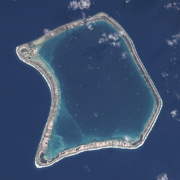
English: NASA Astronaut Image of Fangataufa Atoll (Tuamotu Archipelago, French Polynesia) in the Pacific Ocean
Русский: Космический снимок НАСА атолла Фангатауфа (архипелаг Туамоту, Французская Полинезия) в Тихом океане |
| Data | |
| Font | http://nix.larc.nasa.gov/info;jsessionid=1ci2vn53647eg?id=ISS002-E-7354&orgid=3 |
| Autor | NASA Johnson Space Center - Earth Sciences and Image Analysis |
| Posició de la càmera | | Aquesta i altres imatges properes a: OpenStreetMap |
|---|
Aquest fitxer ha estat catalogat per Johnson Space Center dels Estats Units d'Amèrica per a l'Administració Nacional d'Aeronàutica i de l'Espai (NASA)en virtut identificat com a: ID del fitxer : ISS002-E-7354.Els ID dels fitxers i ID alternatius són traduïts de Photo ID .Aquesta etiqueta no indica l'estat dels drets d'autor de la imatge carregada. Cal un senyal de drets d'autor. Vegeu Commons:Sobre les llicències. Altres idiomes:
|
Llicència
This file is in the public domain in the United States because it was created by the Image Science & Analysis Laboratory, of the NASA Johnson Space Center. NASA copyright policy states that "NASA material is not protected by copyright unless noted". (NASA media use guidelines or Conditions of Use of Astronaut Photographs).
Photo source: ISS002-E-7354.
|

|
Aquesta imatge ha estat avaluada segons els criteris d'imatge valuosa i ha estat considerada la imatge més valuosa que hi ha a Commons referida a l'àmbit: Fangataufa atoll, French Polynesia - satellite view. Pots veure'n la nominació a Commons:Valued image candidates/Fangataufa.JPG. |
Historial del fitxer
Cliqueu una data/hora per veure el fitxer tal com era aleshores.
| Data/hora | Miniatura | Dimensions | Usuari/a | Comentari | |
|---|---|---|---|---|---|
| actual | 21:06, 29 juny 2017 | | 2.000 × 2.000 (402 Ko) | Szczureq | full resolution |
| 17:26, 11 abr 2008 |  | 418 × 433 (53 Ko) | Vriullop | cropped and rotated with north on top | |
| 20:35, 15 oct 2007 |  | 640 × 437 (49 Ko) | Переход Артур | {{Information |Description=TUAMOTU ARCHIPELAGO/FANGATAUFA ATOLL |Source= |Date=06.15.2001 |Author=NASA Johnson Space Center - Earth Sciences and Image Analysis |Permission= |other_versions= }} Category:Tuamotu |
Ús del fitxer
Les 2 pàgines següents utilitzen aquest fitxer:
Ús global del fitxer
Utilització d'aquest fitxer en altres wikis:
- Utilització a ast.wikipedia.org
- Utilització a bg.wikipedia.org
- Utilització a br.wikipedia.org
- Utilització a ceb.wikipedia.org
- Utilització a cs.wikipedia.org
- Utilització a de.wikipedia.org
- Utilització a en.wikipedia.org
- Utilització a es.wikipedia.org
- Utilització a eu.wikipedia.org
- Utilització a fi.wikipedia.org
- Utilització a frr.wikipedia.org
- Utilització a fr.wikipedia.org
- Utilització a gl.wikipedia.org
- Utilització a id.wikipedia.org
- Utilització a it.wikipedia.org
- Utilització a ja.wikipedia.org
- Utilització a ko.wikipedia.org
- Utilització a lt.wikipedia.org
- Utilització a nl.wikipedia.org
- Utilització a no.wikipedia.org
- Utilització a pap.wikipedia.org
- Utilització a pl.wikipedia.org
- Utilització a pl.wiktionary.org
- Utilització a pt.wikipedia.org
- Utilització a ru.wikipedia.org
- Utilització a simple.wikipedia.org
- Utilització a sk.wikipedia.org
- Utilització a sv.wikipedia.org
- Utilització a sv.wiktionary.org
- Utilització a sw.wikipedia.org
- Utilització a uk.wikipedia.org
- Utilització a www.wikidata.org
- Utilització a zh.wikipedia.org