
Fitxer:Fredericksburg-SumnerAssault.png
Mida d'aquesta previsualització: 533 × 600 píxels. Altres resolucions: 213 × 240 píxels | 427 × 480 píxels | 683 × 768 píxels | 910 × 1.024 píxels | 1.820 × 2.048 píxels | 4.800 × 5.400 píxels.
Fitxer original (4.800 × 5.400 píxels, mida del fitxer: 7,37 Mo, tipus MIME: image/png)
| Aquest fitxer i la informació mostrada a continuació provenen del dipòsit multimèdia lliure Wikimedia Commons. |
Resum
| Descripció |
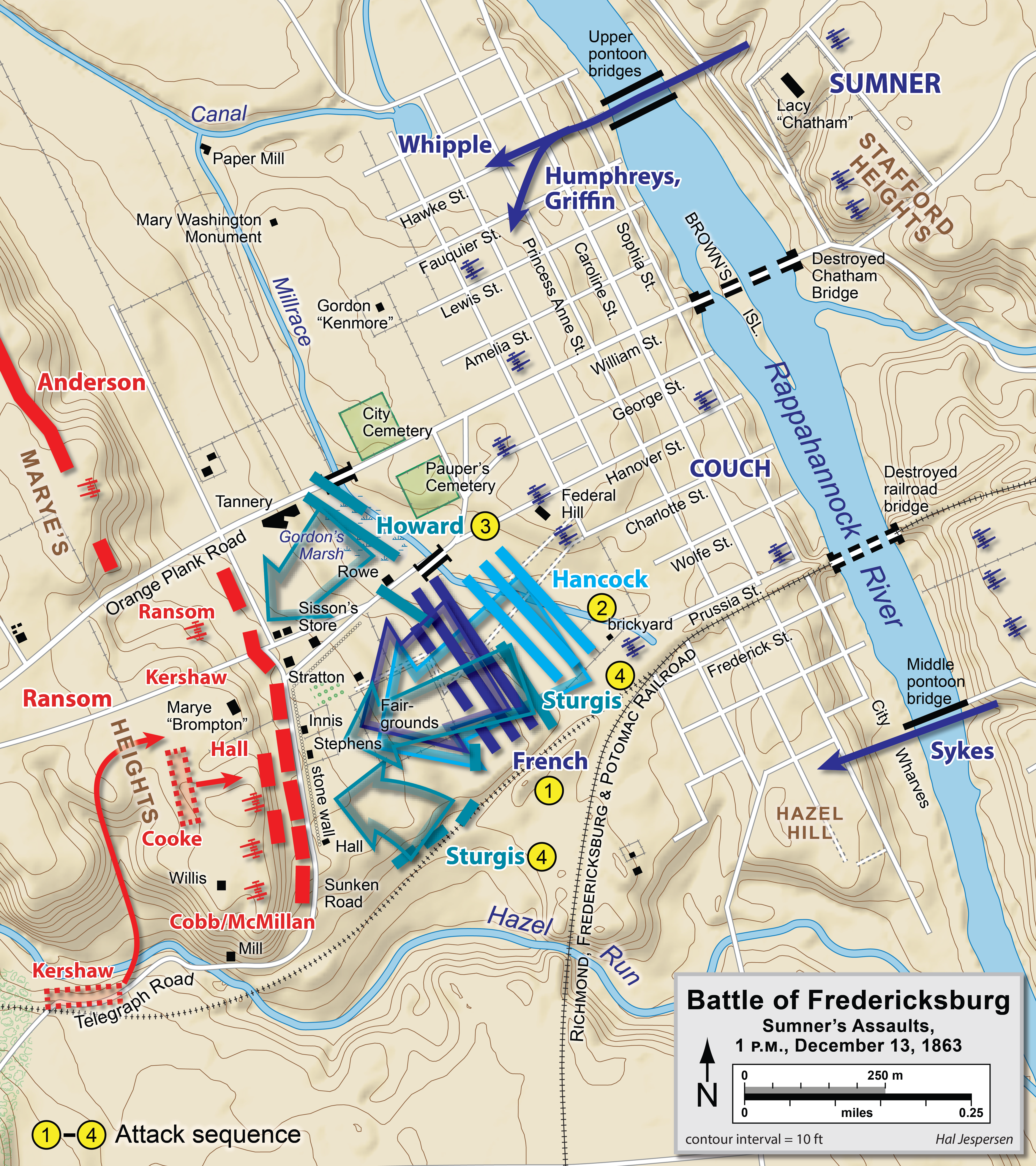
English: Map of the en:Battle of Fredericksburg of the en:American Civil War, Sumner's Assault. Drawn in Adobe Illustrator CS5 by Hal Jespersen. Graphic source file is available at http://www.posix.com/CWmaps/ |
| Data | 31 de març de 2006 (original upload date) |
| Font | Transferred from en.wikipedia to Commons by Falcorian. |
| Autor | The original uploader was Hlj de la Viquipèdia en anglès. |
Llicència
Aquest fitxer està subjecte a la llicència de Creative Commons Reconeixement 3.0 No adaptada.
Reconeixement: Map by Hal Jespersen, www.posix.com/CW
- Sou lliure de:
- compartir – copiar, distribuir i comunicar públicament l'obra
- adaptar – fer-ne obres derivades
- Amb les condicions següents:
- reconeixement – Heu de donar la informació adequada sobre l'autor, proporcionar un enllaç a la llicència i indicar si s'han realitzat canvis. Podeu fer-ho amb qualsevol mitjà raonable, però de cap manera no suggereixi que l'autor us dóna suport o aprova l'ús que en feu.
Registre original de càrregues
La pàgina de descripció original era aquí. Els noms d'usuari a continuació es refereixen a en.wikipedia.
- 2008-01-13 06:59 Falcorian 944×744×8 (233188 bytes) lossless compression with pngout.
- 2006-03-31 00:42 Hlj 944×744×8 (295845 bytes) Map of the [[Battle of Fredericksburg]] of the [[American Civil War]], Sumner's Assault. Drawn by Hal Jespersen in Macromedia Freehand. Graphic source file is available at http://www.posix.com/CWmaps/ {{PD-release}}
Historial del fitxer
Cliqueu una data/hora per veure el fitxer tal com era aleshores.
| Data/hora | Miniatura | Dimensions | Usuari/a | Comentari | |
|---|---|---|---|---|---|
| actual | 21:06, 11 gen 2023 | | 4.800 × 5.400 (7,37 Mo) | Hlj | improved graphics and accuracy |
| 02:01, 28 març 2011 |  | 989 × 783 (269 Ko) | Hlj | Update to more recent graphic format for rivers and roads. Same license. | |
| 23:34, 29 set 2010 |  | 989 × 783 (220 Ko) | Hlj | Updated troop positions/attacks, added some labels. Same license. | |
| 02:03, 9 set 2010 |  | 989 × 783 (221 Ko) | Hlj | Updated to clean up some graphical elements and match the current ACW mapping style. This version is drawn in Adobe Illustrator CS5 by Hal Jespersen. Graphic source file is available at http://www.posix.com/CWmaps/ {{cc-by-3.0|Map by Hal Jespersen, www.po | |
| 09:20, 13 gen 2008 |  | 944 × 744 (228 Ko) | File Upload Bot (Magnus Manske) | {{BotMoveToCommons|en.wikipedia}} {{Information |Description={{en|Map of the en:Battle of Fredericksburg of the en:American Civil War, Sumner's Assault. Drawn by Hal Jespersen in Macromedia Freehand. Graphic source file is available at http://w |
Ús del fitxer
La pàgina següent utilitza aquest fitxer:
Ús global del fitxer
Utilització d'aquest fitxer en altres wikis:
- Utilització a ar.wikipedia.org
- Utilització a da.wikipedia.org
- Utilització a en.wikipedia.org
- Utilització a hu.wikipedia.org
- Utilització a ja.wikipedia.org
- Utilització a ko.wikipedia.org
- Utilització a no.wikipedia.org
- Utilització a pt.wikipedia.org
- Utilització a ro.wikipedia.org
- Utilització a ru.wikipedia.org
- Utilització a zh.wikipedia.org