
Fitxer:Geometrischer plan des Koeniglichen Thiergartens vor Berlin 1765.jpg

Fitxer original (4.673 × 3.858 píxels, mida del fitxer: 8,47 Mo, tipus MIME: image/jpeg)
| Aquest fitxer i la informació mostrada a continuació provenen del dipòsit multimèdia lliure Wikimedia Commons. |
Resum
| Títol |
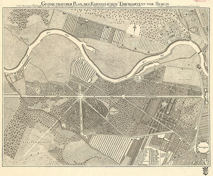
Geometrischer Plan des Koeniglichen Thiergartens vor Berlin / nach dermaliger Beschaffenheit, auf Veranstaltung der Königlichen Academie der Wissenschaften verfertiget. Berlin Anno 1765 |
|||||||||
| Map legend |
Deutsch: Legende frei stehend im rechten unteren Bereich des Plans: Großbuchstaben A–G, Kleinbuchstaben a–z, Postamente der Stauen |
|||||||||
| Data | ||||||||||
| Font | Kartensammlung Moll, Mährische Landesbibliothek (Moravská zemská knihovna) (online) | |||||||||
| Creador |
Desconegut |
|||||||||
| Geotemporal data | ||||||||||
| Map location | Berlín | |||||||||
| Map type | Stadtplan | |||||||||
| Escala | ca 1:5300 | |||||||||
| Heading |
 |
|||||||||
| Bounding box |
|
|||||||||
| Georeferencing | ||||||||||
| Bibliographic data | ||||||||||
| Llengua | alemany | |||||||||
| Archival data | ||||||||||
| Col·lecció | Moravská zemská knihovna | |||||||||
| Número d'inventari |
Moll-0005.047 |
|||||||||
| Dimensions | 44 x 57,5 cm (55 x 65 cm) | |||||||||
| Material/Tècnica |
Deutsch: Kupferdruck |
|||||||||
Llicència
|
Aquest material està en domini públic als Estats Units i als altres països on el dret d'autor s'estén per 70 anys (o menys) després de la mort de l'autor.
| |
| Aquest fitxer està identificat com a lliure de restriccions conegudes sota la llei de drets d'autor, inclosos els drets veïns. | |
Historial del fitxer
Cliqueu una data/hora per veure el fitxer tal com era aleshores.
| Data/hora | Miniatura | Dimensions | Usuari/a | Comentari | |
|---|---|---|---|---|---|
| actual | 20:44, 25 oct 2014 | | 4.673 × 3.858 (8,47 Mo) | Alexrk2 | higher res. from MZK |
| 18:17, 28 març 2007 |  | 1.042 × 840 (555 Ko) | Stephan Herz | {{Information| |Description=Historical map of the "Tiergarten" , a park in Berlin. |Source=Catalogue "Georg Wenzeslaus von Knobelsdorf", edited by Stiftung Preussische Schloesser und Gaerten, Berlin-Brandenburg 1999 |Date=1765 |Painter=Anonymous |Permis |
Ús del fitxer
La pàgina següent utilitza aquest fitxer:
Ús global del fitxer
Utilització d'aquest fitxer en altres wikis:
- Utilització a bg.wikipedia.org
- Utilització a de.wikipedia.org
- Utilització a en.wikipedia.org
- Utilització a et.wikipedia.org