
Fitxer:Hopi reservation partion & Navajo Reservation.JPG

Mida d'aquesta previsualització: 729 × 600 píxels. Altres resolucions: 292 × 240 píxels | 584 × 480 píxels | 934 × 768 píxels | 1.245 × 1.024 píxels | 1.900 × 1.563 píxels.
Fitxer original (1.900 × 1.563 píxels, mida del fitxer: 376 Ko, tipus MIME: image/jpeg)
| Aquest fitxer i la informació mostrada a continuació provenen del dipòsit multimèdia lliure Wikimedia Commons. |
| Descripció |
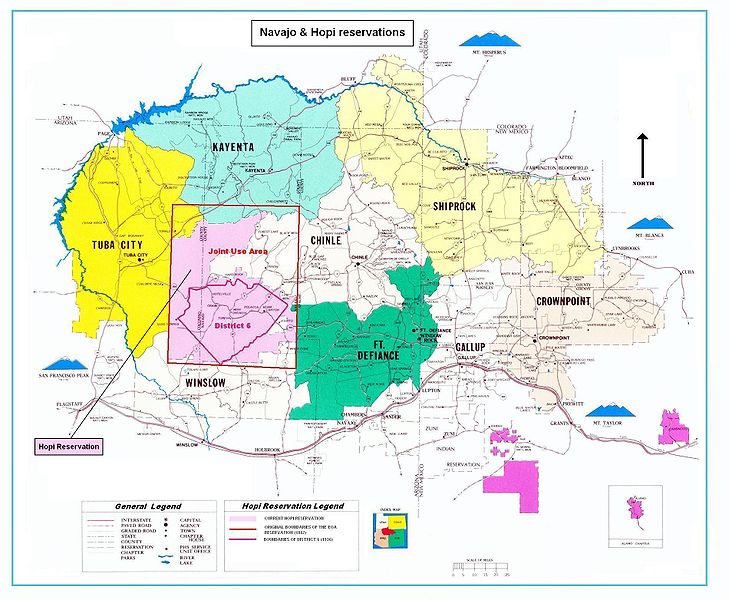
Map of the Hopi reservation in Navajo Nation. The map shows in particular:
|
|||||||||
| Data | (UTC) | |||||||||
| Font | ||||||||||
| Creador |
|
|||||||||
| Geotemporal data | ||||||||||
| Bounding box |
|
|||||||||
| Georeferencing | ||||||||||

|
Aquesta imatge (de tipus mapa) s'hauria de tornar a crear utilitzant gràfics vectorials com ara un fitxer SVG. Això té diversos avantatges; en trobareu més informació a Commons:Media for cleanup. Si ja disposeu d'una versió d'aquesta imatge en format SVG, us preguem que la pengeu; després, reemplaceu aquesta plantilla amb la plantilla {{Vector version available|nom nou de la imatge.svg}} en aquesta imatge.
|


| Això és una imatge retocada, cosa que vol dir que ha estat alterada digitalment de la seva versió original. Modificacions: Boundaries of Hopi reservation end his partition. L'original es pot veure a: Navajo-Nation-Map-PHS.jpg:
|
| This image is in the public domain in the United States because it contains materials that originally came from the U.S. Public Health Service, taken or made as part of an employee's official duties. As works of the U.S. federal government, all Public Health Service images are in the public domain in the United States. | .svg) |
Registre original de càrregues
This image is a derivative work of the following images:
- File:Navajo-Nation-Map-PHS.jpg licensed with PD-USGov
- 2007-07-14T19:22:34Z Bejnar 1900x1563 (1576169 Bytes) {{Information |Description=Map of the Navajo Nation |Source=[http://www.ihs.gov/FacilitiesServices/AreaOffices/Navajo/naihs-nation-map.asp "Navajo Nation Map" Navajo Area Indian Health Service, Public Health Service] |Date=2
Uploaded with derivativeFX
Historial del fitxer
Cliqueu una data/hora per veure el fitxer tal com era aleshores.
| Data/hora | Miniatura | Dimensions | Usuari/a | Comentari | |
|---|---|---|---|---|---|
| actual | 21:41, 12 abr 2010 | | 1.900 × 1.563 (376 Ko) | Mario1952 | Color of image border Category:Maps of Native American tribal territories |
| 17:19, 5 abr 2010 |  | 1.900 × 1.563 (393 Ko) | Mario1952 | {{Information |Description=Map of the Navajo Nation |Source=*File:Navajo-Nation-Map-PHS.jpg |Date=2010-04-05 15:18 (UTC) |Author=*File:Navajo-Nation-Map-PHS.jpg: compiled by Aces Products under contract for the Indian Health Service, US Public |
Ús del fitxer
La pàgina següent utilitza aquest fitxer:
Ús global del fitxer
Utilització d'aquest fitxer en altres wikis:
- Utilització a en.wikipedia.org
- Utilització a fr.wikipedia.org
- Utilització a it.wikipedia.org
- Utilització a oc.wikipedia.org