
Fitxer:Linschoten map.jpg

Mida d'aquesta previsualització: 700 × 600 píxels. Altres resolucions: 280 × 240 píxels | 560 × 480 píxels | 889 × 762 píxels.
Fitxer original (889 × 762 píxels, mida del fitxer: 272 Ko, tipus MIME: image/jpeg)
| Aquest fitxer i la informació mostrada a continuació provenen del dipòsit multimèdia lliure Wikimedia Commons. |
Info
| Descripció |
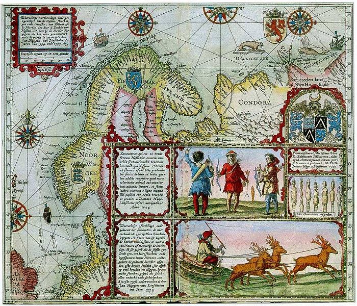
English: A low quality version of the Linschoten map of Scandinavia. Use other versions. |
||||
| Data | Drafted 1590s, engraved 1599, printed 1599 or 1601 | ||||
| Font | A version—dated 1601 and placed at Franeker for no apparent reason—of a map originally printed for inclusion in the 1599 Latin version of Jan Huyghen van Linschoten's Itinerario (at the Hague by Albert Henri de Sallengre as "Alberti Henrici"), which included Linschoten's translation of Gerrit de Veer's journal of Willem Barentsz's voyages to the north in the 1590s, which Linschoten also took part in. | ||||
| Autor | Joannes van Doetecum and Baptista van Doetecum | ||||
| Permís (Com reutilitzar aquest fitxer) |
|
||||
| Altres versions |
|
||||
_(2).jpg)
.jpg)


| Anotacions | Aquesta imatge té anotacions: Vegeu-les a Commons |
Historial del fitxer
Cliqueu una data/hora per veure el fitxer tal com era aleshores.
| Data/hora | Miniatura | Dimensions | Usuari/a | Comentari | |
|---|---|---|---|---|---|
| actual | 10:37, 4 des 2007 | | 889 × 762 (272 Ko) | Sherurcij | {{Information |Description=Map of Barents' voyages |Source=Journal of Jan Huyghens van Linschoten |Date=1601 |Author= Jan Huyghens van Linschoten |Permission={{PD-old}} |other_versions= }} Category:Maps |
| 10:33, 4 des 2007 |  | 576 × 499 (119 Ko) | Sherurcij | {{Information |Description=Map of Barents' voyages |Source=Journal of Jan Huyghens van Linschoten |Date=1601 |Author= Jan Huyghens van Linschoten |Permission={{PD-old}} |other_versions= }} Category:Maps |
Ús del fitxer
No hi ha pàgines que utilitzin aquest fitxer.