
Fitxer:Map of USA HI full.png
No hi ha cap versió amb una resolució més gran.
Map_of_USA_HI_full.png (286 × 186 píxels, mida del fitxer: 21 Ko, tipus MIME: image/png)
| Aquest fitxer i la informació mostrada a continuació provenen del dipòsit multimèdia lliure Wikimedia Commons. |
Resum

|
File:Map of USA HI full.svg és una versió vectorial (SVG) d'aquest fitxer. En cas de ser millor, hauria de ser emprada en lloc d'aquesta imatge tramada.
File:Map of USA HI full.png → File:Map of USA HI full.svg
Per a més informació pel que fa als gràfics vectorials, llegiu la transició a SVG en Commons. També hi ha informació quant a la compatibilitat del MediaWiki amb les imatges SVG. |
 |
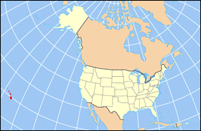
| Descripció | Map of USA with Hawaii highlighted and shown in true position |
| Font | http://www.nationalatlas.gov/printable/reference.html |
| Autor |
Llicència
This map was obtained from an edition of the National Atlas of the United States. Like almost all works of the U.S. federal government, works from the National Atlas are in the public domain in the United States.
Online access: NationalAtlas.gov | 1970 print edition: Library of Congress, Perry-Castañeda Library
|
Historial del fitxer
Cliqueu una data/hora per veure el fitxer tal com era aleshores.
| Data/hora | Miniatura | Dimensions | Usuari/a | Comentari | |
|---|---|---|---|---|---|
| actual | 18:30, 2 abr 2007 | | 286 × 186 (21 Ko) | MattWright | fix to more standard map colors |
| 21:09, 1 abr 2007 |  | 286 × 186 (19 Ko) | MattWright | {{Information |Description=Map of USA with Hawaii highlighted and shown in true position |Source=http://www.nationalatlas.gov/printable/reference.html |Date= |Author= |Permission= |other_versions= }} Category:Maps of the United States [[Category:Maps |
Ús del fitxer
No hi ha pàgines que utilitzin aquest fitxer.
Ús global del fitxer
Utilització d'aquest fitxer en altres wikis:
- Utilització a bcl.wikipedia.org
- Utilització a bo.wikipedia.org
- Utilització a da.wikipedia.org
- Utilització a en.wikipedia.org
- Utilització a es.wikipedia.org
- Utilització a fa.wikipedia.org
- Utilització a hu.wikipedia.org
- Utilització a id.wikipedia.org
- Utilització a ja.wikipedia.org
- Utilització a ko.wikipedia.org
- Utilització a mrj.wikipedia.org
- Utilització a mr.wikipedia.org
- Utilització a pl.wikipedia.org
- Utilització a pl.wikinews.org
- Utilització a pl.wiktionary.org
- Utilització a ro.wikipedia.org
- Utilització a sv.wikipedia.org
- Utilització a uk.wikipedia.org
Vegeu més usos globals d'aquest fitxer.