
Fitxer:Northern Virginia Campaign Aug7-28.png

Mida d'aquesta previsualització: 639 × 599 píxels. Altres resolucions: 256 × 240 píxels | 512 × 480 píxels | 819 × 768 píxels | 1.092 × 1.024 píxels | 2.195 × 2.059 píxels.
Fitxer original (2.195 × 2.059 píxels, mida del fitxer: 978 Ko, tipus MIME: image/png)
| Aquest fitxer i la informació mostrada a continuació provenen del dipòsit multimèdia lliure Wikimedia Commons. |
Resum
| Descripció |
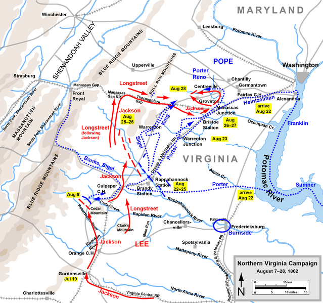
English: Map of the Northern Virginia Campaign of the American Civil War. Drawn by Hal Jespersen in Adobe Illustrator CS5. Graphic source file is available at http://www.posix.com/CWmaps/ |
| Font | http://www.posix.com/CWmaps/ |
| Autor | Hal Jespersen at en.wikipedia |
| Permís (Com reutilitzar aquest fitxer) |
CC-BY-3.0. |
Llicència
Hal Jespersen at en.wikipedia, el titular dels drets d'autor d'aquest treball, el public sota la següent llicència:
Aquest fitxer està subjecte a la llicència de Creative Commons Reconeixement 3.0 No adaptada.
Reconeixement: Map by Hal Jespersen, www.posix.com/CW
- Sou lliure de:
- compartir – copiar, distribuir i comunicar públicament l'obra
- adaptar – fer-ne obres derivades
- Amb les condicions següents:
- reconeixement – Heu de donar la informació adequada sobre l'autor, proporcionar un enllaç a la llicència i indicar si s'han realitzat canvis. Podeu fer-ho amb qualsevol mitjà raonable, però de cap manera no suggereixi que l'autor us dóna suport o aprova l'ús que en feu.
Historial del fitxer
Cliqueu una data/hora per veure el fitxer tal com era aleshores.
| Data/hora | Miniatura | Dimensions | Usuari/a | Comentari | |
|---|---|---|---|---|---|
| actual | 21:42, 24 març 2011 | | 2.195 × 2.059 (978 Ko) | Hlj | Update graphical style of rivers and roads. Minor cleanup. Same license. |
| 22:45, 22 juny 2009 |  | 1.500 × 1.413 (485 Ko) | DR | {{Information |Description={{en|1=Map of the Northern Virginia Campaign of the American Civil War. Drawn by Hal Jespersen in Adobe Illustrator. Graphic source file is available at http://www.posix.com/CWmaps/}} |Source=http://www.posix.com/CWmaps/ |Author |
Ús del fitxer
La pàgina següent utilitza aquest fitxer:
Ús global del fitxer
Utilització d'aquest fitxer en altres wikis:
- Utilització a azb.wikipedia.org
- Utilització a en.wikipedia.org
- Utilització a es.wikipedia.org
- Utilització a fa.wikipedia.org
- Utilització a fr.wikipedia.org
- Utilització a hu.wikipedia.org
- Utilització a it.wikipedia.org
- Utilització a nl.wikipedia.org
- Utilització a no.wikipedia.org
- Utilització a pt.wikipedia.org
- Utilització a ru.wikipedia.org
- Utilització a vi.wikipedia.org