
Fitxer:Official LanguagesMap-Africa.png
No hi ha cap versió amb una resolució més gran.
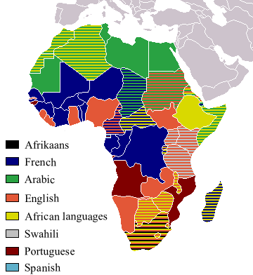
Official_LanguagesMap-Africa.png (360 × 392 píxels, mida del fitxer: 21 Ko, tipus MIME: image/png)
| Aquest fitxer i la informació mostrada a continuació provenen del dipòsit multimèdia lliure Wikimedia Commons. |

|
File:Official LanguagesMap-Africa.svg és una versió vectorial (SVG) d'aquest fitxer. En cas de ser millor, hauria de ser emprada en lloc d'aquesta imatge tramada.
File:Official LanguagesMap-Africa.png → File:Official LanguagesMap-Africa.svg
Per a més informació pel que fa als gràfics vectorials, llegiu la transició a SVG en Commons. També hi ha informació quant a la compatibilitat del MediaWiki amb les imatges SVG. |
 |
Taken from Image:BlankMap-Africa.png. Information from http://www.nationsonline.org/oneworld/index.html and CIA World Factbook
| Jo, el titular del copyright d'aquesta obra, l'allibero al domini públic. Això s'aplica a tot el món. En alguns països això pot no ser legalment possible, en tal cas: Jo faig concessió a tothom del dret d'usar aquesta obra per a qualsevol propòsit, sense cap condició llevat d'aquelles requerides per la llei. |
Other version
-
 Afrikaans
 -
 Français


Historial del fitxer
Cliqueu una data/hora per veure el fitxer tal com era aleshores.
| Data/hora | Miniatura | Dimensions | Usuari/a | Comentari | |
|---|---|---|---|---|---|
| actual | 20:05, 16 març 2018 | | 360 × 392 (21 Ko) | Maphobbyist | Updates |
| 14:54, 6 maig 2008 |  | 746 × 813 (250 Ko) | Ant75 | Updated Madagascar to English, French and Traditional African following 2007 Constitution. | |
| 14:54, 1 maig 2008 |  | 720 × 784 (186 Ko) | Ant75 | Updated Sudan to English and Arabic following 2005 Constitution. | |
| 21:59, 16 març 2007 |  | 360 × 392 (14 Ko) | Rasulo~commonswiki | Updated earlier version due to officialization of Swahili in Uganda. Also corrected the language status of Zimbabwe where Shona and Ndebele are currently co-official with English. | |
| 19:05, 19 maig 2005 |  | 360 × 392 (14 Ko) | Rydia~commonswiki | Taken from Image:BlankMap-Africa.png. Information from http://www.nationsonline.org/oneworld/index.html and CIA World Factbook {{PD}} |
Ús del fitxer
Les 2 pàgines següents utilitzen aquest fitxer:
Ús global del fitxer
Utilització d'aquest fitxer en altres wikis:
- Utilització a de.wikipedia.org
- Utilització a he.wikivoyage.org
- Utilització a kg.wikipedia.org
- Utilització a oc.wikipedia.org
- Utilització a pam.wikipedia.org
- Utilització a ss.wikipedia.org