
Fitxer:PearlHarborCarrierChart.jpg

Mida d'aquesta previsualització: 800 × 566 píxels. Altres resolucions: 320 × 226 píxels | 640 × 453 píxels | 1.004 × 710 píxels.
Fitxer original (1.004 × 710 píxels, mida del fitxer: 213 Ko, tipus MIME: image/jpeg)
| Aquest fitxer i la informació mostrada a continuació provenen del dipòsit multimèdia lliure Wikimedia Commons. |

|
Aquesta imatge (de tipus military map) s'hauria de tornar a crear utilitzant gràfics vectorials com ara un fitxer SVG. Això té diversos avantatges; en trobareu més informació a Commons:Media for cleanup. Si ja disposeu d'una versió d'aquesta imatge en format SVG, us preguem que la pengeu; després, reemplaceu aquesta plantilla amb la plantilla {{Vector version available|nom nou de la imatge.svg}} en aquesta imatge.
|


Resum
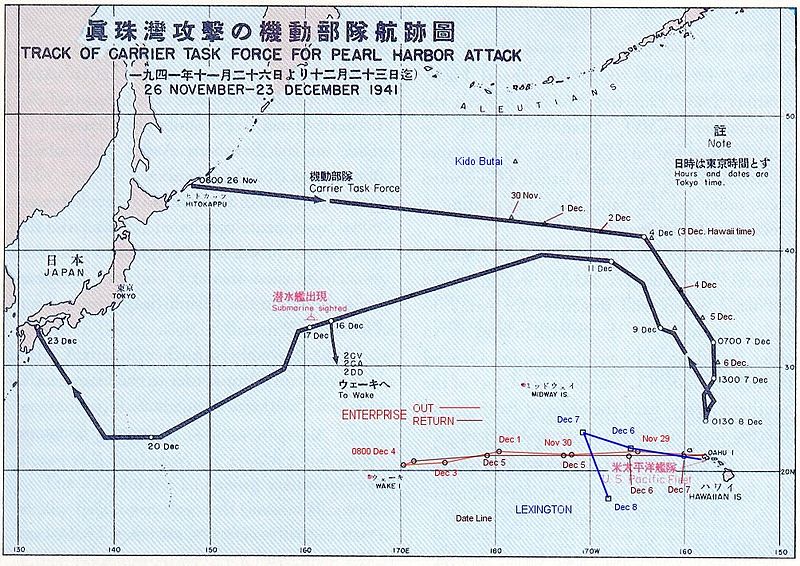
Español: La flota Japonesa se movilizó sin ser detectada rumbo a Pearl Harbor.
English: The route of the Japanese flotilla (Kido Butai), with the USS Enterprise (in red) and the USS Lexington (in blue) to the South.
Public Domain chart from "Reports of General MacArthur, prepared by his General Staff." This book was printed by GPO. The chart shows the routes of the Japanese attack force to and from Pearl Harbor. I have added the routes of the two American carriers.
Aquesta obra és en el domini públic als Estats Units perquè és una obra del govern federal dels Estats Units sota els termes del Títol 17, Capítol 1, Secció 105 del Codi dels EUA. Vegeu drets d'autor.
Nota: Això només s'aplica a obres del Govern Federal i no a les dels estats individuals ni cap altra subdivisió administrativa. Aquesta plantilla tampoc no s'aplica a dissenys de segells de correus publicats pel Servei Postal dels Estats Units des de 1978 (vegeu 206.02(b) of Compendium II: Copyright Office Practices).
|
 | |
| Aquest fitxer està identificat com a lliure de restriccions conegudes sota la llei de drets d'autor, inclosos els drets veïns. | ||
(got from en.wikipedia)
Historial del fitxer
Cliqueu una data/hora per veure el fitxer tal com era aleshores.
| Data/hora | Miniatura | Dimensions | Usuari/a | Comentari | |
|---|---|---|---|---|---|
| actual | 17:20, 18 oct 2005 | | 1.004 × 710 (213 Ko) | Unf~commonswiki | Public Domain chart from "Reports of General MacArthur, prepared by his General Staff." This book was printed by GPO. The chart shows the routes of the Japanese attack force to and from Pearl Harbor. I have added the routes of the two American carriers. |
Ús del fitxer
La pàgina següent utilitza aquest fitxer:
Ús global del fitxer
Utilització d'aquest fitxer en altres wikis:
- Utilització a af.wikipedia.org
- Utilització a ar.wikipedia.org
- Utilització a az.wikipedia.org
- Utilització a bg.wikipedia.org
- Utilització a cs.wikipedia.org
- Utilització a da.wikipedia.org
- Utilització a en.wikipedia.org
- Utilització a et.wikipedia.org
- Utilització a fr.wikipedia.org
- Utilització a fy.wikipedia.org
- Utilització a he.wikipedia.org
- Utilització a hu.wikipedia.org
- Utilització a id.wikipedia.org
- Utilització a it.wikipedia.org
- Utilització a ja.wikipedia.org
- Utilització a ms.wikipedia.org
- Utilització a nl.wikipedia.org
- Utilització a no.wikipedia.org
- Utilització a pl.wikipedia.org
- Utilització a pt.wikipedia.org
- Utilització a ru.wikipedia.org
- Utilització a sk.wikipedia.org
- Utilització a tr.wikipedia.org
- Utilització a ur.wikipedia.org
- Utilització a vi.wikipedia.org
- Utilització a zh.wikipedia.org