
Fitxer:Race to the Sea 1914.png

Mida d'aquesta previsualització: 493 × 600 píxels. Altres resolucions: 197 × 240 píxels | 395 × 480 píxels | 740 × 900 píxels.
Fitxer original (740 × 900 píxels, mida del fitxer: 71 Ko, tipus MIME: image/png)
| Aquest fitxer i la informació mostrada a continuació provenen del dipòsit multimèdia lliure Wikimedia Commons. |
| Descripció |
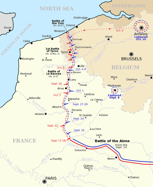
Map showing the course of the "Race to the Sea" during 1914 following the Battle of the Aisne. Allied front line and movement is shown in red, German front line and movement shown in blue. Three of the battles that occurred during or after the "race" are shown boxed. Based on a map from A Short Military History of World War I - Atlas, edited by T. Dodson Stamps and Vincent J. Esposito, 1950. |
| Data | |
| Font | Gsl Originally uploaded to EN Wikipedia 8 August 2004 |
| Autor | Gsl |
| S'ha alliberat aquesta obra al domini públic pel seu autor Gsl de la Viquipèdia en anglès. Això s'aplica a tot el món. En alguns països això pot no ser legalment possible, en tal cas: Gsl concedeix a tothom el dret d'usar aquesta obra per a qualsevol propòsit, sense cap condició llevat d'aquelles requerides per la llei. |
Historial del fitxer
Cliqueu una data/hora per veure el fitxer tal com era aleshores.
| Data/hora | Miniatura | Dimensions | Usuari/a | Comentari | |
|---|---|---|---|---|---|
| actual | 20:18, 5 gen 2014 | | 740 × 900 (71 Ko) | Hohum | Fix minor mistake |
| 20:16, 5 gen 2014 |  | 740 × 900 (71 Ko) | Hohum | More map-like | |
| 07:59, 5 nov 2007 |  | 740 × 900 (72 Ko) | Rcbutcher | {{Information |Description=Map showing the course of the "Race to the Sea" during 1914 following the Battle of the Aisne. Allied front line and movement is shown in red, German front line and movement shown in blue. Three of |
Ús del fitxer
La pàgina següent utilitza aquest fitxer:
Ús global del fitxer
Utilització d'aquest fitxer en altres wikis:
- Utilització a ar.wikipedia.org
- Utilització a azb.wikipedia.org
- Utilització a be-tarask.wikipedia.org
- Utilització a be.wikipedia.org
- Utilització a de.wikipedia.org
- Utilització a en.wikipedia.org
- Douglas Haig, 1st Earl Haig
- British Expeditionary Force (World War I)
- 63rd (Royal Naval) Division
- First Battle of the Aisne
- Battle of Albert (1914)
- 1st Royal Naval Brigade
- Draft:Douglas Haig in 1914-15
- First Battle of Picardy
- Wikipedia:WikiProject Military history/News/November 2014/World War I timeline
- Wikipedia:WikiProject Military history/News/November 2014/Op-ed
- Utilització a es.wikipedia.org
- Utilització a eu.wikipedia.org
- Utilització a fi.wikipedia.org
- Utilització a fr.wikipedia.org
- Utilització a gl.wikipedia.org
- Utilització a he.wikipedia.org
- Utilització a hu.wikipedia.org
- Utilització a id.wikipedia.org
- Utilització a it.wikipedia.org
Vegeu més usos globals d'aquest fitxer.