
Fitxer:Satellite image of Flevopolder, Netherlands (5.48E 52.43N).png

Mida d'aquesta previsualització: 800 × 548 píxels. Altres resolucions: 320 × 219 píxels | 640 × 439 píxels | 1.024 × 702 píxels.
Fitxer original (1.024 × 702 píxels, mida del fitxer: 1,49 Mo, tipus MIME: image/png)
| Aquest fitxer i la informació mostrada a continuació provenen del dipòsit multimèdia lliure Wikimedia Commons. |
.png?uselang=ca)
| Descripció |
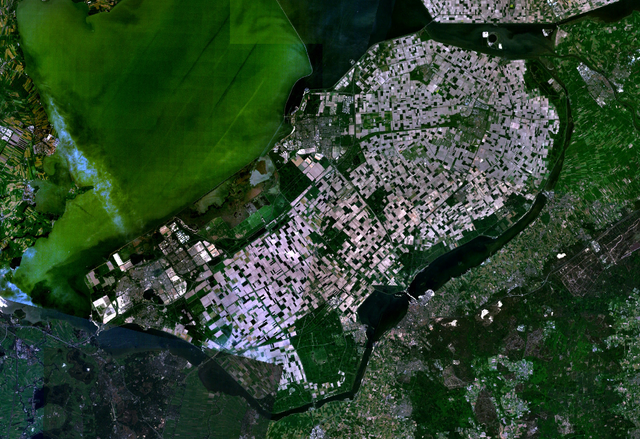
English: Satellite image of the Flevopolder in the Netherlands. Technically, the Flevopolder consists of Zuidelijk Flevoland (Southern Flevoland), Oostelijk Flevoland (Eastern Flevoland) and the Noordoostpolder (North Eastern Polder). This image shows Southern and Eastern Flevoland. |
| Font | Screenshot from NASA's World Wind |
| Autor | Fotografia: NASA |
| This image is in the public domain because it is a screenshot from NASA’s globe software World Wind using a public domain layer, such as Blue Marble, MODIS, Landsat, SRTM, USGS or GLOBE.
|
 |
Historial del fitxer
Cliqueu una data/hora per veure el fitxer tal com era aleshores.
| Data/hora | Miniatura | Dimensions | Usuari/a | Comentari | |
|---|---|---|---|---|---|
| actual | 15:25, 4 maig 2005 | | 1.024 × 702 (1,49 Mo) | Galwaygirl | Satellite image of the Flevopolder in the Netherlands. Screenshot from NASA's World Wind {{PD}} |
Ús del fitxer
La pàgina següent utilitza aquest fitxer:
Ús global del fitxer
Utilització d'aquest fitxer en altres wikis:
- Utilització a an.wikipedia.org
- Utilització a ar.wikipedia.org
- Utilització a ast.wikipedia.org
- Utilització a br.wikipedia.org
- Utilització a cs.wikipedia.org
- Utilització a da.wikipedia.org
- Utilització a de.wikipedia.org
- Utilització a el.wikipedia.org
- Utilització a en.wikipedia.org
- Utilització a es.wikipedia.org
- Utilització a eu.wikipedia.org
- Utilització a fa.wikipedia.org
- Utilització a fr.wikipedia.org
- Utilització a gl.wikipedia.org
- Utilització a he.wikipedia.org
- Utilització a hr.wikipedia.org
- Utilització a hy.wikipedia.org
- Utilització a id.wikipedia.org
- Utilització a kk.wikipedia.org
- Utilització a ko.wikipedia.org
- Utilització a ms.wikipedia.org
- Utilització a nl.wikipedia.org
- Utilització a no.wikipedia.org
- Utilització a oc.wikipedia.org
- Utilització a ro.wikipedia.org
- Utilització a ru.wikipedia.org
- Utilització a sh.wikipedia.org
- Utilització a simple.wikipedia.org
- Utilització a sr.wikipedia.org
Vegeu més usos globals d'aquest fitxer.
.png)
.png)