
Fitxer:Torpedoed Japanese destroyer Yamakaze sinking on 25 June 1942.jpg

Mida d'aquesta previsualització: 759 × 599 píxels. Altres resolucions: 304 × 240 píxels | 608 × 480 píxels | 973 × 768 píxels | 1.280 × 1.011 píxels | 2.560 × 2.021 píxels | 2.937 × 2.319 píxels.
Fitxer original (2.937 × 2.319 píxels, mida del fitxer: 3,84 Mo, tipus MIME: image/jpeg)
| Aquest fitxer i la informació mostrada a continuació provenen del dipòsit multimèdia lliure Wikimedia Commons. |
Resum
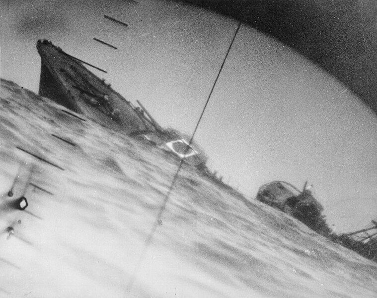
| Descripció | Sinking of the Japanese destroyer Yamakaze on 25 June 1942 approximately 110 km southeast of Yokosuku, Japan, photographed through the periscope of the U.S. Navy submarine USS Nautilus (SS-168). This position is given in The Official Chronology of the U.S. Navy in World War II by Robert Cressman. NH 111751 says 75 miles southwest of Yokahama Harbor. Yokahama is near Yokosuku. | |||
| Data | ||||
| Font |
|
|||
| Autor | U.S. Navy | |||
| Altres versions | Official U.S. Navy photo NH 111751 from the U.S. Navy Naval History and Heritage Command |
| Posició de la càmera | | Aquesta i altres imatges properes a: OpenStreetMap |
|---|
|
Llicència
Aquesta imatge és obra d'un mariner o empleat de l'U.S. Navy feta durant la prestació oficial de servei. Com a obra del govern federal dels EUA, la imatge és en el domini públic.
|
 | |
| Aquest fitxer està identificat com a lliure de restriccions conegudes sota la llei de drets d'autor, inclosos els drets veïns. | ||
Historial del fitxer
Cliqueu una data/hora per veure el fitxer tal com era aleshores.
| Data/hora | Miniatura | Dimensions | Usuari/a | Comentari | |
|---|---|---|---|---|---|
| actual | 08:37, 9 oct 2016 | | 2.937 × 2.319 (3,84 Mo) | Cobatfor | new NHHC file |
| 22:55, 21 ago 2007 |  | 2.985 × 2.048 (1,5 Mo) | BrokenSphere | == Summary == {{Information |Description=Torpedoed Japanese destroyer photographed through periscope of U.S.S. Wahoo or U.S.S. Nautilus, June 1942. (Navy) Exact Date Shot Unknown NARA FILE #: 080-G-418331 WAR & CONFLICT BOOK #: 1315 |Source=High resolutio |
Ús del fitxer
Les 6 pàgines següents utilitzen aquest fitxer:
Ús global del fitxer
Utilització d'aquest fitxer en altres wikis:
- Utilització a ar.wikipedia.org
- Utilització a azb.wikipedia.org
- Utilització a bg.wikipedia.org
- Utilització a bn.wikipedia.org
- Utilització a cs.wikipedia.org
- Utilització a en.wikipedia.org
- Periscope
- Pacific War
- USS Nautilus (SS-168)
- Salmon-class submarine
- Japanese destroyer Yamakaze (1936)
- Talk:Japanese destroyer Yamakaze (1936)
- Wikipedia:Featured pictures/History/World War II
- Allied submarines in the Pacific War
- List of shipwrecks in June 1942
- User talk:TomStar81/Archive 17
- Wikipedia:Featured pictures thumbs/51
- Wikipedia:Featured picture candidates/The death of the Imperial Japanese Destroyer Yamakaze as seen through the periscope of the submarine USS Nautilus (SS-168)
- Wikipedia:Featured picture candidates/April-2015
- Wikipedia:WikiProject Military history/News/May 2015/Articles
- Wikipedia:Wikipedia Signpost/2015-04-15/Featured content
- Wikipedia:Wikipedia Signpost/Single/2015-04-15
- List of maritime disasters in World War II
- Template:POTD/2018-06-25
- Wikipedia:Picture of the day/June 2018
- Wikipedia:Main Page history/2018 June 25
- Utilització a es.wikipedia.org
- Utilització a eu.wikipedia.org
- Utilització a fa.wikipedia.org
- Utilització a fi.wikipedia.org
- Utilització a fr.wikipedia.org
- Utilització a hu.wikipedia.org
- Utilització a id.wikipedia.org
- Utilització a it.wikipedia.org
- Utilització a ja.wikipedia.org
- Utilització a ko.wikipedia.org
- Utilització a nl.wikipedia.org
- Utilització a pl.wikipedia.org
- Utilització a pnb.wikipedia.org
- Utilització a pt.wikipedia.org
- Utilització a ru.wikipedia.org
Vegeu més usos globals d'aquest fitxer.