
Fitxer:Tribes of Sicily by 11th century BC.png
No hi ha cap versió amb una resolució més gran.
Tribes_of_Sicily_by_11th_century_BC.png (659 × 438 píxels, mida del fitxer: 29 Ko, tipus MIME: image/png)
| Aquest fitxer i la informació mostrada a continuació provenen del dipòsit multimèdia lliure Wikimedia Commons. |

|
Aquesta imatge (de tipus ethnographic map) s'hauria de tornar a crear utilitzant gràfics vectorials com ara un fitxer SVG. Això té diversos avantatges; en trobareu més informació a Commons:Media for cleanup. Si ja disposeu d'una versió d'aquesta imatge en format SVG, us preguem que la pengeu; després, reemplaceu aquesta plantilla amb la plantilla {{Vector version available|nom nou de la imatge.svg}} en aquesta imatge.
|
Resum
| Descripció |
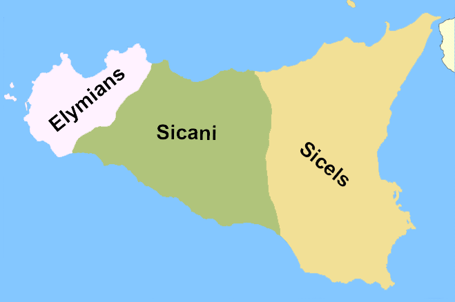
English: A rough reconstruction of the locations of the Elymians, Sicani and Sicels in Sicily around 11th century BC, before the arrival of the Phoenicians and the Greeks. Note from author: "This is a map I created which roughly depicts the location of the native Italic tribes of Sicily, no exact borders are known (as of October 2007) so this is to be taken in the context of rough areas. To devise this I have used the following informative sources[1][2][3] Version labelled in Esperanto can be reached at eo:Dosiero:Praaj triboj de Sicilio.png".
This is highly questionable. There may not even have been any "Sicels" on Sicily before the "arrival of the Phoenicians". The map is just pulled from thin air and has no relation to the 11th century. At best it shows the rough location of the three tribal groups around the 6th century.
Français : Localisation des différentes tribus en Sicile avant la colonisation grecque.
Español: Pueblos prerromanos de Sicilia: elimios (elymiī), sicanos (sicānī) y sículos (siculī). Mapa con la localización aproximada de las tribus siciliotas antes de la llegada de los griegos.
Русский: Схема расселения догреческих народов Сицилии (слева направо: элимцы, сиканы, сикулы). Схема расселения догреческих народов Сицилии (слева направо: элимцы, сиканы, сикулы). Территории племён на о. Сицилия к приходу греков. Схема расселения догреческих народов Сицилии (слева направо: элимцы, сиканы, сикулы).
Português: Os Sicanos habitavam o centro da Sicília.
Svenska: Folkslagen sikeler, elymer och sikaner: den ungefärliga utbredningen innan grekernas ankomst. Folkslagen sikeler, elymer och sikaner: den ungefärliga utbredningen innan grekernas ankomst. Folkslagen sikeler, elymer och sikaner: den ungefärliga utbredningen innan grekernas ankomst.
Català: Mapa de la situació dels sicans.
Norsk bokmål: En grovt kart over fordelingen av innfødte stammene på Sicilia i oldtiden. Et kart over Sicilia som grovt viser inndelingen av de tre folkeslagene.
Українська: Схема розселення догрецьких народів Сицилії (зліва направо: Еліми, Сікани, Сікули). Схема розселення догрецьких народів Сицилії (зліва направо: Елімці, Сікани, Сікули). Схема розселення догрецьких народів Сицилії (зліва направо: Елімці, Сікани, Сікули).
Čeština: Pravděpodobné rozmístění tří italických národů obývajících Sicílii.
Српски / srpski: Мапа положаја италских племена на Сицилији.
Lietuvių: Elymų žemės Sicilijoje. Sikanų žemės Sicilijoje.
العربية: خريطة تقريبية لانتشار الشعوب الصقلية القديمة. خريطة تقريبية لانتشار الشعوب الصقلية القديمة.
Hrvatski: Okvirna karta drevnih naroda na Siciliji. Karta položaja italskih plemena na Siciliji. Gruba karta drevnih sicilijansklih naroda. Okvirna karta drevnih naroda na Siciliji.
Eesti: Vanimad hõimud Sitsiilias.
Srpskohrvatski / српскохрватски: Okvirna karta drevnih naroda na Siciliji. Karta položaja italskih plemena na Siciliji. Gruba karta drevnih sicilijansklih naroda. Okvirna karta plemenske podjele Sicilije prije dolaska Grka.
Sicilianu: La Sicilia agghiri lu 1000 a.C. (Sicels significa Siculi nto ngrisi). |
| Data | |
| Font | Self-published work by Soprani |
| Autor | Soprani |
| Altres versions |
|


![[2]](http://www.conigliofamily.com/images/SicilyMap.jpg)
![[3]](https://en.wikipedia.org/wiki/Image:Sicily_elymians.png)
Llicència
Jo, el titular dels drets d'autor d'aquest treball, el public sota les següents llicències:

|
S'autoritza la còpia, la distribució i la modificació d'aquest document sota els termes de la llicència de documentació lliure GNU versió 1.2 o qualsevol altra versió posterior que publiqui la Free Software Foundation; sense seccions invariants, ni textos de portada, ni textos de contraportada. S'inclou una còpia d'aquesta llicència en la secció titulada GNU Free Documentation License. |
| Aquest fitxer està subjecte a la llicència de Creative Commons Reconeixement i Compartir Igual 3.0 No adaptada. | ||
| ||
| Aquest avís de llicència s'ha afegit a aquest fitxer d'acord amb l'actualització de la llicència GFDL. |
Podeu seleccionar la llicència que vulgueu.
Historial del fitxer
Cliqueu una data/hora per veure el fitxer tal com era aleshores.
| Data/hora | Miniatura | Dimensions | Usuari/a | Comentari | |
|---|---|---|---|---|---|
| actual | 20:23, 7 oct 2007 | | 659 × 438 (29 Ko) | Soprani~commonswiki | This is a map I created which roughly depicts the location of the native Italic tribes of Sicily, no exact borders are known (as of October 2007) so this is to be taken in the context of rough areas. To devise this I have used the following informative so |
Ús del fitxer
No hi ha pàgines que utilitzin aquest fitxer.
Ús global del fitxer
Utilització d'aquest fitxer en altres wikis:
- Utilització a ar.wikipedia.org
- Utilització a ast.wikipedia.org
- Utilització a az.wikipedia.org
- Utilització a cs.wikipedia.org
- Utilització a de.wikipedia.org
- Utilització a en.wikipedia.org
- Utilització a et.wikipedia.org
- Utilització a fr.wikipedia.org
- Utilització a hr.wikipedia.org
- Utilització a hy.wikipedia.org
- Utilització a ja.wikipedia.org
- Utilització a lt.wikipedia.org
- Utilització a nl.wikipedia.org
- Utilització a no.wikipedia.org
- Utilització a pl.wikipedia.org
- Utilització a scn.wikipedia.org
- Utilització a sh.wikipedia.org
- Utilització a simple.wikipedia.org
- Utilització a sr.wikipedia.org
- Utilització a sv.wikipedia.org
- Utilització a uk.wikipedia.org
- Utilització a www.wikidata.org
- Utilització a zh.wikipedia.org