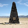
Fitxer:Trinity Site Obelisk National Historic Landmark.jpg

Mida d'aquesta previsualització: 600 × 600 píxels. Altres resolucions: 240 × 240 píxels | 480 × 480 píxels | 768 × 768 píxels | 1.024 × 1.024 píxels | 2.300 × 2.300 píxels.
Fitxer original (2.300 × 2.300 píxels, mida del fitxer: 3,49 Mo, tipus MIME: image/jpeg)
Historial del fitxer
Cliqueu una data/hora per veure el fitxer tal com era aleshores.
| Data/hora | Miniatura | Dimensions | Usuari/a | Comentari | |
|---|---|---|---|---|---|
| actual | 20:29, 16 jul 2013 |  | 2.300 × 2.300 (3,49 Mo) | Soerfm | Crop, contrast |
| 16:55, 13 gen 2011 |  | 2.530 × 2.530 (4,09 Mo) | Flickr upload bot | Uploaded from http://flickr.com/photo/99842842@N00/5079553260 using Flickr upload bot |
Ús del fitxer
La pàgina següent utilitza aquest fitxer:
Ús global del fitxer
Utilització d'aquest fitxer en altres wikis:
- Utilització a af.wikipedia.org
- Utilització a ast.wikipedia.org
- Utilització a da.wikipedia.org
- Utilització a de.wikipedia.org
- Utilització a el.wikipedia.org
- Utilització a en.wikipedia.org
- Utilització a en.wikiquote.org
- Utilització a en.wikivoyage.org
- Utilització a es.wikipedia.org
- Utilització a es.wikivoyage.org
- Utilització a et.wikipedia.org
- Utilització a eu.wikipedia.org
- Utilització a fi.wikipedia.org
- Utilització a fr.wikipedia.org
- Utilització a he.wikipedia.org
- Utilització a ja.wikipedia.org
- Utilització a ml.wikipedia.org
- Utilització a nl.wikipedia.org
- Utilització a pt.wikipedia.org
- Utilització a ro.wikipedia.org
- Utilització a rue.wikipedia.org
- Utilització a sr.wikipedia.org
- Utilització a sv.wikipedia.org
- Utilització a ta.wikipedia.org
- Utilització a th.wikipedia.org
- Utilització a uk.wikipedia.org
- Utilització a vi.wikipedia.org
- Utilització a www.wikidata.org
- Utilització a zh.wikipedia.org


