
Fitxer:Tz-map.png
No hi ha cap versió amb una resolució més gran.
Tz-map.png (256 × 274 píxels, mida del fitxer: 32 Ko, tipus MIME: image/png)
| Aquest fitxer i la informació mostrada a continuació provenen del dipòsit multimèdia lliure Wikimedia Commons. |
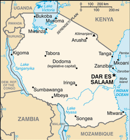
CIA map of Tanzania
This image is in the public domain because it contains materials that originally came from the United States Central Intelligence Agency's World Factbook.
|
 |
Historial del fitxer
Cliqueu una data/hora per veure el fitxer tal com era aleshores.
| Data/hora | Miniatura | Dimensions | Usuari/a | Comentari | |
|---|---|---|---|---|---|
| actual | 21:59, 8 set 2012 | | 256 × 274 (32 Ko) | Thricecube | Updated version of the map. |
| 01:14, 5 març 2005 |  | 330 × 351 (14 Ko) | Alfio | CIA map of Tanzania |
Ús del fitxer
No hi ha pàgines que utilitzin aquest fitxer.
Ús global del fitxer
Utilització d'aquest fitxer en altres wikis:
- Utilització a an.wikipedia.org
- Utilització a be-tarask.wikipedia.org
- Utilització a bjn.wikipedia.org
- Utilització a bn.wikipedia.org
- Utilització a br.wikipedia.org
- Utilització a cs.wikipedia.org
- Utilització a da.wikipedia.org
- Utilització a de.wikipedia.org
- Utilització a en.wikipedia.org
- Utilització a es.wikipedia.org
- Utilització a fi.wikipedia.org
- Utilització a fr.wikipedia.org
- Utilització a fy.wikipedia.org
- Utilització a he.wikipedia.org
- Utilització a hu.wikipedia.org
- Utilització a hu.wiktionary.org
- Utilització a id.wikipedia.org
- Utilització a io.wikipedia.org
- Utilització a is.wikipedia.org
- Utilització a it.wikipedia.org
- Utilització a ja.wikipedia.org
- Utilització a kg.wikipedia.org
- Utilització a ln.wikipedia.org
- Utilització a mi.wikipedia.org
- Utilització a nds.wikipedia.org
- Utilització a nl.wiktionary.org
- Utilització a nn.wikipedia.org
- Utilització a pl.wikivoyage.org
- Utilització a pt.wikipedia.org
- Utilització a ro.wikipedia.org
- Utilització a scn.wikipedia.org
Vegeu més usos globals d'aquest fitxer.