
Fitxer:U-Bahn Wien, Netzplan.svg

Mida d'aquesta previsualització PNG del fitxer SVG: 637 × 600 píxels. Altres resolucions: 255 × 240 píxels | 510 × 480 píxels | 816 × 768 píxels | 1.088 × 1.024 píxels | 2.176 × 2.048 píxels | 835 × 786 píxels.
Fitxer original (fitxer SVG, nominalment 835 × 786 píxels, mida del fitxer: 152 Ko)
| Aquest fitxer i la informació mostrada a continuació provenen del dipòsit multimèdia lliure Wikimedia Commons. |
Resum
| Descripció |
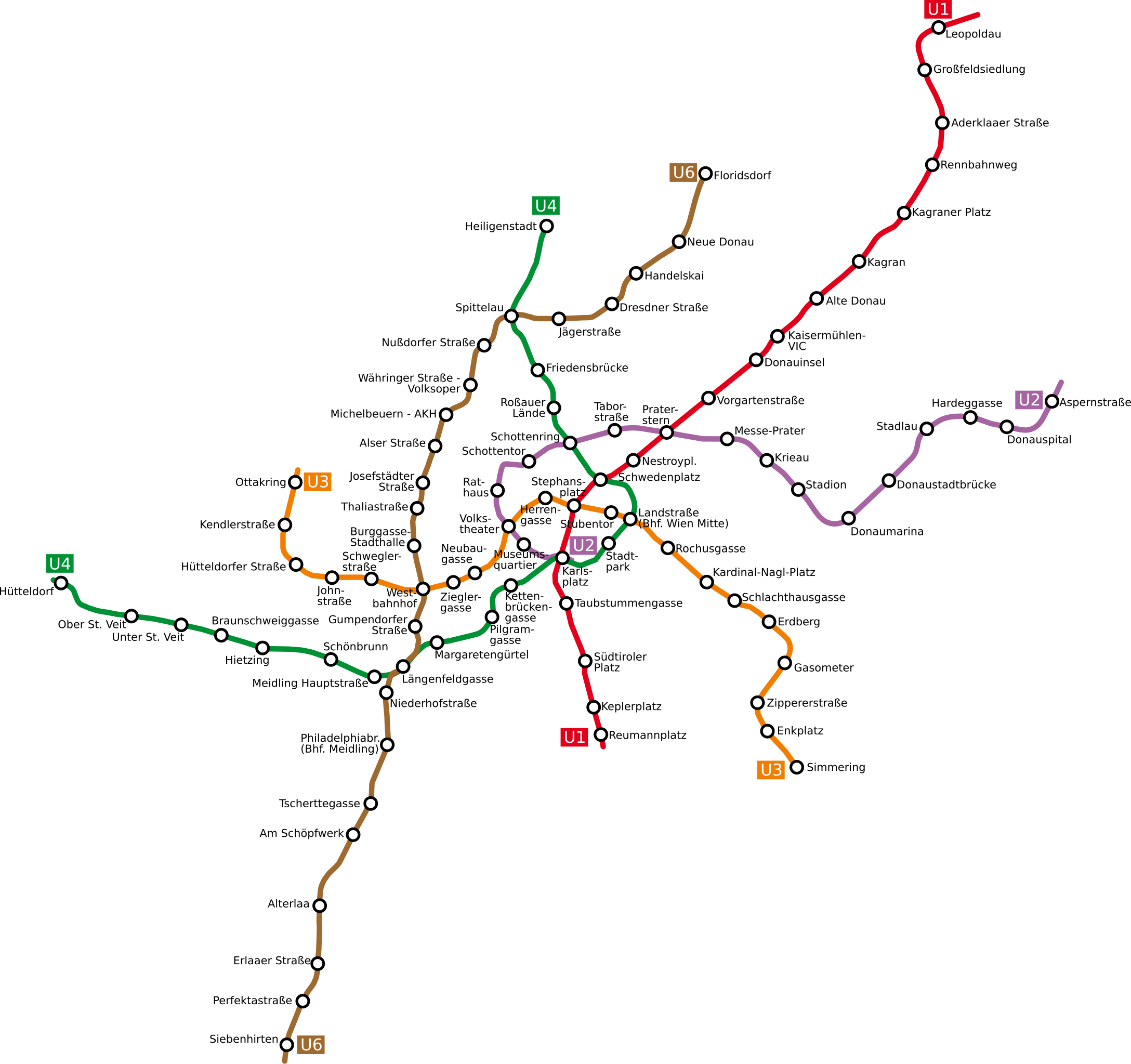
Deutsch: Netzplan der Wiener U-Bahn
English: The underground network of the Austrian capital Vienna
Esperanto: La metroreto de la Aŭstruja ĉefurbo Vieno
Polski: Plan wiedeńskiego metra |
| Data | |
| Font | http://www.openstreetmap.org/browse/relation/27116 |
| Autor | OpenStreetMap contributors, Ircecho |
| SVG genesis | El codi font d’aquest SVG no és vàlid perquè hi 90 han errors. Aquesta imatge vectorial ha estat creada amb Inkscape, or with something else. |
Llicència
Jo, el titular dels drets d'autor d'aquest treball, el public sota la següent llicència:
Aquest fitxer està publicat sota la llicència de Creative Commons Reconeixement i Compartir Igual 2.0 Genèrica.
- Sou lliure de:
- compartir – copiar, distribuir i comunicar públicament l'obra
- adaptar – fer-ne obres derivades
- Amb les condicions següents:
- reconeixement – Heu de donar la informació adequada sobre l'autor, proporcionar un enllaç a la llicència i indicar si s'han realitzat canvis. Podeu fer-ho amb qualsevol mitjà raonable, però de cap manera no suggereixi que l'autor us dóna suport o aprova l'ús que en feu.
- compartir igual – Si modifiqueu, transformeu, o generareu amb el material, haureu de distribuir les vostres contribucions sota una llicència similar o una de compatible com l'original
Historial del fitxer
Cliqueu una data/hora per veure el fitxer tal com era aleshores.
| Data/hora | Miniatura | Dimensions | Usuari/a | Comentari | |
|---|---|---|---|---|---|
| actual | 17:07, 12 abr 2011 | | 835 × 786 (152 Ko) | Ircecho | I now improved readability. Additionally i removed the city border as to make the update just an update. As based on my research i think the old plan is incorrect, its in my opinion right to overwrite it with this redo. |
| 16:30, 8 abr 2011 |  | 1.063 × 1.020 (136 Ko) | Invisigoth67 | Reverted to version as of 18:54, 30 March 2011: Please do not overwrite with a complete new plan, use an new filename instead. This version is much better readable than the new layout. | |
| 20:28, 4 abr 2011 |  | 1.488 × 1.052 (271 Ko) | Ircecho | Redid the whole plan. | |
| 20:54, 30 març 2011 |  | 1.063 × 1.020 (136 Ko) | Ircecho | Extended the map to include the expansion state of 2011. Track and station positions are based on openstreetmap data, which was aligned to stations Donauinsel, Vorgartenstrasse, Krieau, Kardinal-Nagl-Platz and Schlachthausgasse. Stadion was moved a bit, f | |
| 19:44, 11 maig 2008 |  | 982 × 1.031 (132 Ko) | Aldaron | == Summary == {{Information |Description=*de: Netzplan der Wiener U-Bahn *en: The underground network of the Austrian capital Vienna |Source= |Date=2007 |Author=Based on original upload by L.m.k |Permission= |other_versions= }} | |
| 13:19, 13 març 2007 |  | 982 × 1.031 (127 Ko) | Hukkepakk | == Summary == {{Information |Description=*[:de:]] Netzplan der Wiener U-Bahn *en: The underground network of the Austrian capital Vienna.}} |Source= |Date=2007 |Author=L.m.k |Permission= |other_versions= }} == Licensing == {{self2|GFD |
Ús del fitxer
La pàgina següent utilitza aquest fitxer:
Ús global del fitxer
Utilització d'aquest fitxer en altres wikis:
- Utilització a da.wikipedia.org
- Utilització a de.wikipedia.org
- Utilització a eo.wikipedia.org
- Utilització a ro.wikipedia.org
- Utilització a ru.wikivoyage.org
- Utilització a sk.wikipedia.org