
Fitxer:Klang Valley and Outlying Rail Transport.svg

Mida d'aquesta previsualització PNG del fitxer SVG: 800 × 596 píxels. Altres resolucions: 320 × 239 píxels | 640 × 477 píxels | 1.024 × 763 píxels | 1.280 × 954 píxels | 2.560 × 1.908 píxels | 3.033 × 2.261 píxels.
Fitxer original (fitxer SVG, nominalment 3.033 × 2.261 píxels, mida del fitxer: 1,24 Mo)
| Aquest fitxer i la informació mostrada a continuació provenen del dipòsit multimèdia lliure Wikimedia Commons. |
Resum
| Descripció |
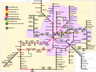
English: Kuala Lumpur, Klang Valley and outlying areas regional rail transports (2008) |
| Data | |
| Font | Treball propi (Original text: self-made) |
| Autor | Bukhrin (talk) |
| Altres versions | Derivative works of this file: Rapid KL map (with regional rail lines).jpg |
.jpg)
Llicència
Bukhrin de la Viquipèdia en anglès, el titular dels drets d'autor d'aquest treball, el public sota les següents llicències:
Aquest fitxer està subjecte a la llicència de Creative Commons Reconeixement i Compartir Igual 3.0 No adaptada.
Reconeixement: Bukhrin de la Viquipèdia en anglès
- Sou lliure de:
- compartir – copiar, distribuir i comunicar públicament l'obra
- adaptar – fer-ne obres derivades
- Amb les condicions següents:
- reconeixement – Heu de donar la informació adequada sobre l'autor, proporcionar un enllaç a la llicència i indicar si s'han realitzat canvis. Podeu fer-ho amb qualsevol mitjà raonable, però de cap manera no suggereixi que l'autor us dóna suport o aprova l'ús que en feu.
- compartir igual – Si modifiqueu, transformeu, o generareu amb el material, haureu de distribuir les vostres contribucions sota una llicència similar o una de compatible com l'original

|
S'autoritza la còpia, la distribució i la modificació d'aquest document sota els termes de la llicència de documentació lliure GNU versió 1.2 o qualsevol altra versió posterior que publiqui la Free Software Foundation; sense seccions invariants, ni textos de portada, ni textos de contraportada. S'inclou una còpia d'aquesta llicència en la secció titulada GNU Free Documentation License. |
Podeu seleccionar la llicència que vulgueu.
Registre original de càrregues
Transferred from en.wikipedia to Commons by Logan using CommonsHelper.
La pàgina de descripció original era aquí. Els noms d'usuari a continuació es refereixen a en.wikipedia.
- 2008-04-11 12:41 Bukhrin 2049×2261× (120721 bytes) reuploaded - missed the Pasar Seni station
- 2008-03-30 09:38 Bukhrin 1943×2146× (119994 bytes) {{Information |Description=Kuala Lumpur, Klang Valley and outlying areas regional rail transports (2008) |Source=self-made |Date=30 March 2008 |Location=Kuala Lumpur, Malaysia |Author=[[User:Bukhrin|Bukhrin]] ([[User talk:Bukhrin|talk]]) |ot
- 2008-03-30 09:34 Bukhrin 2065×2146× (127449 bytes) Reverted to version as of 09:22, 30 March 2008
- 2008-03-30 09:33 Bukhrin 2087×2146× (127454 bytes) {{Information |Description=Kuala Lumpur, Klang Valley and outlying areas regional rail transports (2008) |Source=self-made |Date=30 March 2008 |Location=Kuala Lumpur, Malaysia |Author=[[User:Bukhrin|Bukhrin]] ([[User talk:Bukhrin|talk]]) |ot
- 2008-03-30 09:22 Bukhrin 2065×2146× (127449 bytes) {{Information |Description=Kuala Lumpur, Klang Valley and outlying areas regional rail transports (2008) |Source=self-made |Date=30 March 2008 |Location=Kuala Lumpur, Malaysia |Author=~~~ |other_versions= }}
Historial del fitxer
Cliqueu una data/hora per veure el fitxer tal com era aleshores.
| Data/hora | Miniatura | Dimensions | Usuari/a | Comentari | |
|---|---|---|---|---|---|
| actual | 21:13, 17 nov 2017 | | 3.033 × 2.261 (1,24 Mo) | Derkommander0916 | Map of rail transit systems in Selangor and Kuala Lumpur. Updated to include the LRT Sri Petaling Line and Kelana Jaya Line extensions, the MRT Sungai Buloh-Kajang Line, Sunway BRT and KTM Komuter new routes. Included route numbers and state boundaries. |
| 05:30, 9 març 2011 |  | 2.049 × 2.261 (118 Ko) | Leo db | {{Information |Description={{en|Kuala Lumpur, Klang Valley and outlying areas regional rail transports (2008)}} |Source=Transferred from [http://en.wikipedia.org en.wikipedia]; transfer was stated to be made by User:Leo_db.<br/> (Original text : ''sel | |
| 05:29, 9 març 2011 |  | 2.049 × 2.261 (118 Ko) | File Upload Bot (Magnus Manske) | {{BotMoveToCommons|en.wikipedia|year={{subst:CURRENTYEAR}}|month={{subst:CURRENTMONTHNAME}}|day={{subst:CURRENTDAY}}}} {{Information |Description={{en|Kuala Lumpur, Klang Valley and outlying areas regional rail transports (2008)}} |Source=Transferred fro |
Ús del fitxer
La pàgina següent utilitza aquest fitxer:
Ús global del fitxer
Utilització d'aquest fitxer en altres wikis:
- Utilització a en.wikipedia.org
- Utilització a fr.wikipedia.org