
Fitxer:Abkhazia summary map.png
No hi ha cap versió amb una resolució més gran.
Abkhazia_summary_map.png (250 × 185 píxels, mida del fitxer: 26 Ko, tipus MIME: image/png)
| Aquest fitxer i la informació mostrada a continuació provenen del dipòsit multimèdia lliure Wikimedia Commons. |
Resum
| Descripció |
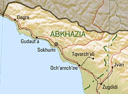
English: Summary map of Abkhazia as of 1999. |
| Data | |
| Font | Cropped version of Georgia (Shaded Relief) 1999 from Perry-Castañeda Library Map Collection: Republic of Georgia Maps |
| Autor | U.S. Central Intelligence Agency |
| Permís (Com reutilitzar aquest fitxer) |
Public domain |
Llicència
| This image is a work of a Central Intelligence Agency employee, taken or made as part of that person's official duties. As a Work of the United States Government, this image or media is in the public domain in the United States.
|

|
nl:Afbeelding:Abkhazia summary map.png
Historial del fitxer
Cliqueu una data/hora per veure el fitxer tal com era aleshores.
| Data/hora | Miniatura | Dimensions | Usuari/a | Comentari | |
|---|---|---|---|---|---|
| actual | 20:46, 11 gen 2006 | | 250 × 185 (26 Ko) | Maksim | La bildo estas kopiita de wikipedia:nl. La originala priskribo estas: Bron: en:Image:Abkhazia_summary_map.png {{PD}} categorie:Kaart {| border="1" ! date/time || username || edit summary |---- | 22 jun 2005 13:09 || [[:nl:Gebruiker:Michiel1972 |
Ús del fitxer
La pàgina següent utilitza aquest fitxer:
Ús global del fitxer
Utilització d'aquest fitxer en altres wikis:
- Utilització a cs.wikipedia.org
- Utilització a hu.wikipedia.org
- Utilització a it.wikipedia.org
- Utilització a nl.wikipedia.org
- Utilització a pl.wikipedia.org
- Utilització a sv.wikipedia.org
- Utilització a uk.wikipedia.org