
Fitxer:20170805 Bolivia 1214 Sucre sRGB (26204168039).jpg

Fitxer original (3.648 × 2.736 píxels, mida del fitxer: 2,16 Mo, tipus MIME: image/jpeg)
| Aquest fitxer i la informació mostrada a continuació provenen del dipòsit multimèdia lliure Wikimedia Commons. |
.jpg?uselang=ca)
Resum
| Descripció |
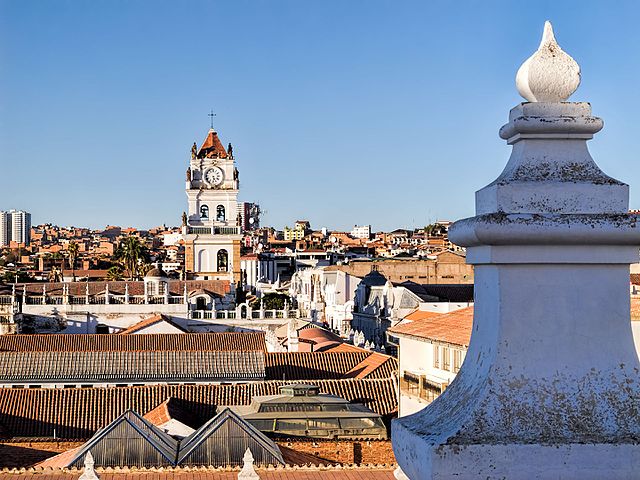
The roof of the Convent of St. Felipe Neri (built in the 17th century and now a museum) provides a panoramic view of the rooftops of Sucre. The tower with the clock in the distance is the bell tower for the Metropolitan Cathedral of Sucre (built between 1559 and 1712 with the clock brought over from London in 1722). Sucre is known as “The White City” because most of the buildings are painted white—and usually have a roof of terracotta tiles. Sucre (elev. 2,810m/9,214ft) was founded by the Spanish in 1538 as Ciudad de la Plata de la Nueva Toledo (Silver City of New Toledo). It became the judicial, religious, and cultural center of the region. Bolivia achieved independence from Spain on 6 August 1825, the last country in Latin America to do so. In 1839 the city was declared the capital of Bolivia and renamed in honor of Antonio José de Sucre (1795-1830), a leader of the fight for independence who was a close friend of Simón Bolívar and served as the second president of Bolivia from the end of 1825 to 1828. (The administrative capital of Bolivia shifted to La Paz in 1898.) The Historic City of Sucre was declared a UNESCO World Heritage Site in 1991. On Google Earth: Convento de San Felipe Neri 19° 3'0.53"S, 65°15'39.91"W Catedral Metropolitana 19° 2'55.48"S, 65°15'35.81"W |
| Data | |
| Font | 20170805_Bolivia_1214 Sucre sRGB |
| Autor | Dan Lundberg |
| Posició de la càmera | | Aquesta i altres imatges properes a: OpenStreetMap |
|---|
.jpg¶ms=-19.049284_N_-065.260462_E_globe:Earth_type:camera_source:Flickr_&language=ca)
Llicència
- Sou lliure de:
- compartir – copiar, distribuir i comunicar públicament l'obra
- adaptar – fer-ne obres derivades
- Amb les condicions següents:
- reconeixement – Heu de donar la informació adequada sobre l'autor, proporcionar un enllaç a la llicència i indicar si s'han realitzat canvis. Podeu fer-ho amb qualsevol mitjà raonable, però de cap manera no suggereixi que l'autor us dóna suport o aprova l'ús que en feu.
- compartir igual – Si modifiqueu, transformeu, o generareu amb el material, haureu de distribuir les vostres contribucions sota una llicència similar o una de compatible com l'original
| This image was originally posted to Flickr by Dan Lundberg at https://flickr.com/photos/9508280@N07/26204168039 (archive). It was reviewed on 2 de novembre de 2017 by FlickreviewR 2 and was confirmed to be licensed under the terms of the cc-by-sa-2.0. |
Historial del fitxer
Cliqueu una data/hora per veure el fitxer tal com era aleshores.
| Data/hora | Miniatura | Dimensions | Usuari/a | Comentari | |
|---|---|---|---|---|---|
| actual | 17:58, 2 nov 2017 | | 3.648 × 2.736 (2,16 Mo) | Ser Amantio di Nicolao | Transferred from Flickr via Flickr2Commons |
Ús del fitxer
La pàgina següent utilitza aquest fitxer:
Ús global del fitxer
Utilització d'aquest fitxer en altres wikis:
- Utilització a ar.wikipedia.org
- Utilització a en.wikipedia.org
- Utilització a es.wikipedia.org
- Utilització a mk.wikipedia.org
- Utilització a ml.wikipedia.org
- Utilització a ru.wikipedia.org
- Utilització a sw.wikipedia.org
- Utilització a vi.wikipedia.org
.jpg)