
Fitxer:B26056036F - Descripcion de las Indias del Poniente 14.jpg
Mida d'aquesta previsualització: 800 × 598 píxels. Altres resolucions: 320 × 239 píxels | 640 × 478 píxels | 1.024 × 765 píxels | 1.280 × 957 píxels | 2.560 × 1.913 píxels | 6.091 × 4.552 píxels.
Fitxer original (6.091 × 4.552 píxels, mida del fitxer: 5,28 Mo, tipus MIME: image/jpeg)
| Aquest fitxer i la informació mostrada a continuació provenen del dipòsit multimèdia lliure Wikimedia Commons. |
Resum
| Descripció |
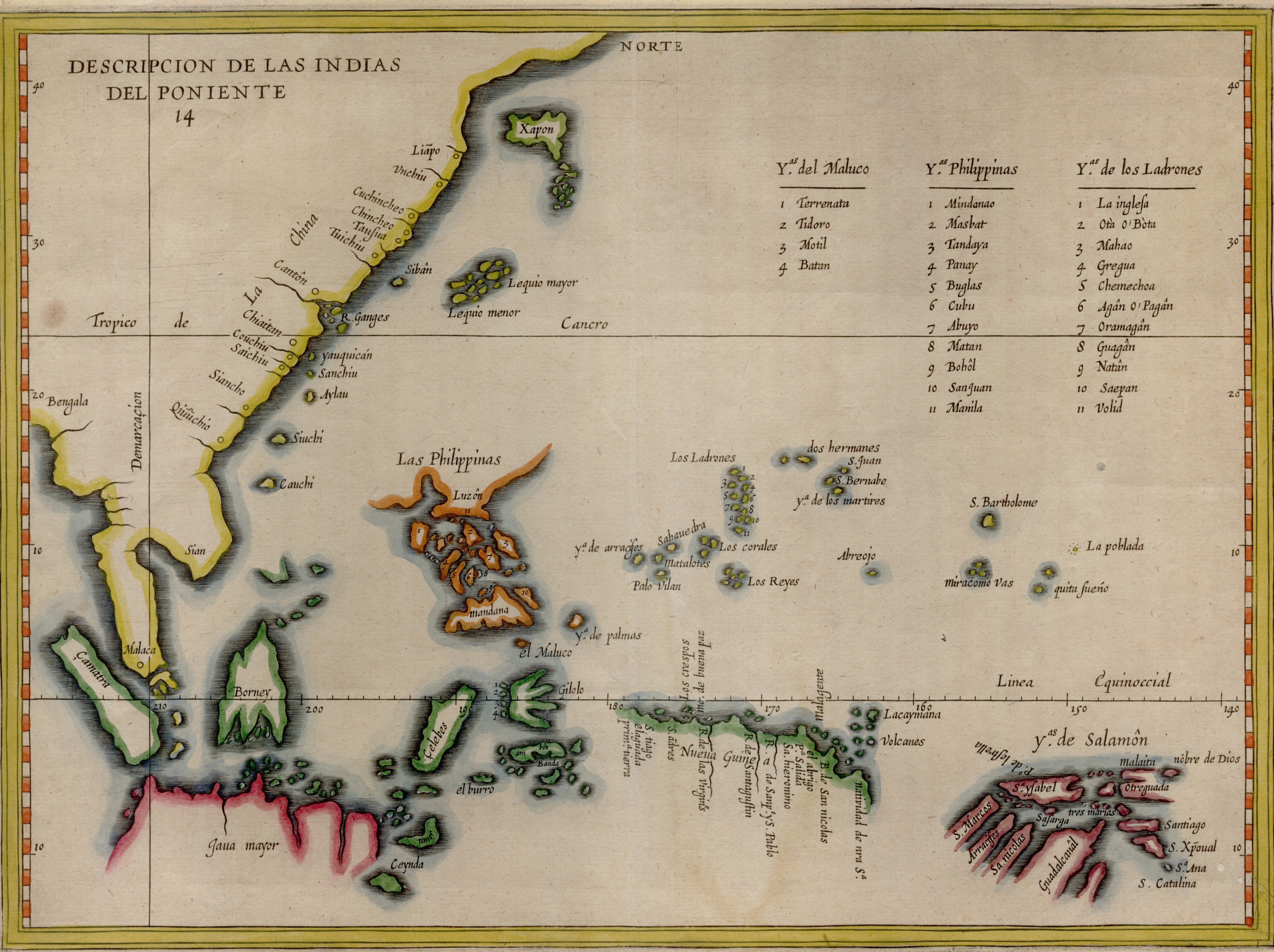
English: Map depicting the line of demarcation between Spanish and Portuguese interests in the East as well as tabulate the Molucca, Philippine and Mariana island groups. Based on Lopez de Velasco's manuscript map of circa 1575, the map was first published by Herrera y Todesillas in his history of Spain in 1601. The current map originates from De Bry's Petits voyages |
| Data | |
| Font | NLB Singapore, David Parry Southeast Asian Map Collection. Available on BookSG https://eresources.nlb.gov.sg/printheritage/detail/57be68af-977a-448a-997c-3ba708f1163d.aspx |
| Autor | Herrera y Tordesillas, Antonio de, -1625; LoÌpez de Velasco, Juan, active 16th century; Bry, Theodor de, 1528-1598 |
Llicència
| L'ús d'aquest fitxer és regulat sota les condicions de Creative Commons de CC0 1.0 lliurament al domini públic universal. | |
| La persona que ha associat un treball amb aquest document ha dedicat l'obra domini públic, renunciant en tot el món a tots els seus drets de d'autor i a tots els drets legals relacionats que tenia en l'obra, en la mesura permesa per la llei. Podeu copiar, modificar, distribuir i modificar l'obra, fins i tot amb fins comercials, tot sense demanar permís.
|
Historial del fitxer
Cliqueu una data/hora per veure el fitxer tal com era aleshores.
| Data/hora | Miniatura | Dimensions | Usuari/a | Comentari | |
|---|---|---|---|---|---|
| actual | 10:34, 30 des 2021 | | 6.091 × 4.552 (5,28 Mo) | NLSingapore | Uploaded a work by Herrera y Tordesillas, Antonio de, -1625; LoÌpez de Velasco, Juan, active 16th century; Bry, Theodor de, 1528-1598 from NLB Singapore, David Parry Southeast Asian Map Collection. Available on BookSG https://eresources.nlb.gov.sg/printheritage/detail/57be68af-977a-448a-997c-3ba708f1163d.aspx with UploadWizard |
Ús del fitxer
La pàgina següent utilitza aquest fitxer:
Ús global del fitxer
Utilització d'aquest fitxer en altres wikis:
- Utilització a eu.wikipedia.org