
Fitxer:Beijing (40298461021).jpg

Fitxer original (4.885 × 4.201 píxels, mida del fitxer: 5,5 Mo, tipus MIME: image/jpeg)
| Aquest fitxer i la informació mostrada a continuació provenen del dipòsit multimèdia lliure Wikimedia Commons. |
.jpg?uselang=ca)
Resum
| Descripció |
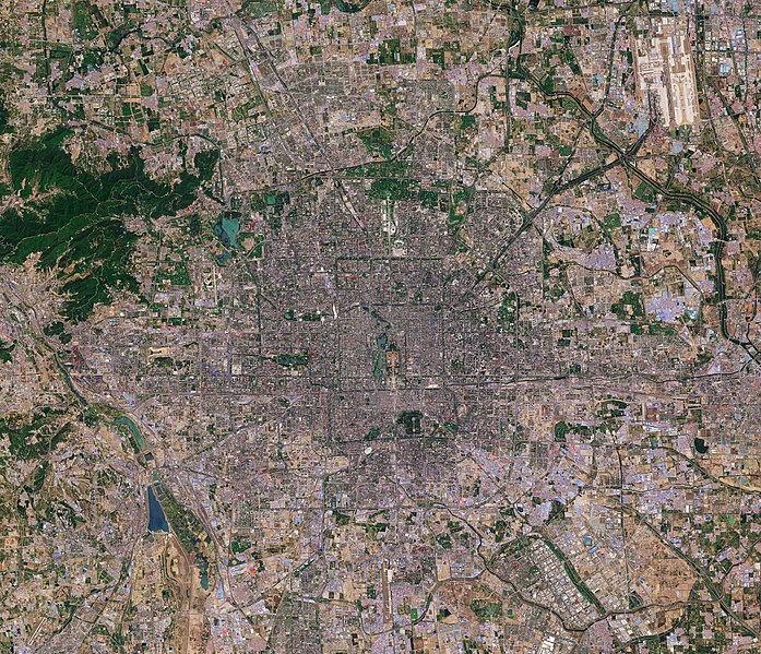
Today, 16 February, upwards of 20% of the world’s population will be celebrating Chinese New Year, also known as the Spring Festival. According to the traditional Chinese calendar, which is based on the lunar cycle and the position of the Sun, the New Year changes each year, but always falls between 21 January and 20 February. There are 12 Chinese zodiac animals that represent years, and 2018 is the year of the dog. Marking this special day, we take a look at a Sentinel-2 image of Beijing, the capital of China. It is one of the most populous cities in the world, with over 21 million people, but during the New Year millions travel from the big cities back to their hometowns to spend the holiday with their families in what is considered the world’s largest annual migration. Beijing lies in northeast China at the northern tip of the North China Plain. While the city lies on flat ground, it is surrounded by mountains to the north and west (not pictured). From space, the city appears to be divided up into many squares, which is a consequence of it being one of oldest planned cities in the world. Beijing’s present urban form was established in the early Ming dynasty – between 1368 and 1644 – with planning stipulating that the city should be a square encompassing nine avenues running north–south and nine running east–west. While this Copernicus Sentinel-2 image details much of the city, a number of famous landmarks can be picked out easily. For example, lying in the heart of Beijing, the Forbidden City, one of China’s largest and best preserved heritage sites, and Tiananmen Square can be seen. Happy Chinese Year – or Xīn nián kuài lè – to all. This Sentinel-2 image, which was captured on 3 May 2016, is also featured on the <a href="http://www.esa.int/spaceinvideos/Videos/2018/02/Earth_from_Space_Beijing/" rel="noreferrer nofollow">Earth from Space video programme</a>. Credits: contains modified Copernicus Sentinel data (2016), processed by ESA, <a href="https://creativecommons.org/licenses/by-sa/3.0/igo/" rel="noreferrer nofollow">CC BY-SA 3.0 IGO</a> |
|||||||||
| Data | ||||||||||
| Font | Beijing | |||||||||
| Creador | ||||||||||
| Geotemporal data | ||||||||||
| Bounding box |
|
|||||||||
| Georeferencing | ||||||||||
| Posició de la càmera | | Aquesta i altres imatges properes a: OpenStreetMap |
|---|
.jpg¶ms=039.918952_N_0116.388816_E_globe:Earth_type:camera_source:Flickr_&language=ca)
Llicència
- Sou lliure de:
- compartir – copiar, distribuir i comunicar públicament l'obra
- adaptar – fer-ne obres derivades
- Amb les condicions següents:
- reconeixement – Heu de donar la informació adequada sobre l'autor, proporcionar un enllaç a la llicència i indicar si s'han realitzat canvis. Podeu fer-ho amb qualsevol mitjà raonable, però de cap manera no suggereixi que l'autor us dóna suport o aprova l'ús que en feu.
- compartir igual – Si modifiqueu, transformeu, o generareu amb el material, haureu de distribuir les vostres contribucions sota una llicència similar o una de compatible com l'original
| This image was originally posted to Flickr by europeanspaceagency at https://flickr.com/photos/37472264@N04/40298461021 (archive). It was reviewed on 2 de març de 2020 by FlickreviewR 2 and was confirmed to be licensed under the terms of the cc-by-sa-2.0. |
Historial del fitxer
Cliqueu una data/hora per veure el fitxer tal com era aleshores.
| Data/hora | Miniatura | Dimensions | Usuari/a | Comentari | |
|---|---|---|---|---|---|
| actual | 04:02, 2 març 2020 | | 4.885 × 4.201 (5,5 Mo) | Up and Go | Transferred from Flickr via #flickr2commons |
Ús del fitxer
La pàgina següent utilitza aquest fitxer:
Ús global del fitxer
Utilització d'aquest fitxer en altres wikis:
.jpg)