
Fitxer:Byzantine empire 1355.jpg

Mida d'aquesta previsualització: 758 × 600 píxels. Altres resolucions: 304 × 240 píxels | 607 × 480 píxels | 971 × 768 píxels | 1.134 × 897 píxels.
Fitxer original (1.134 × 897 píxels, mida del fitxer: 380 Ko, tipus MIME: image/jpeg)
| Aquest fitxer i la informació mostrada a continuació provenen del dipòsit multimèdia lliure Wikimedia Commons. |
Resum
| Descripció |
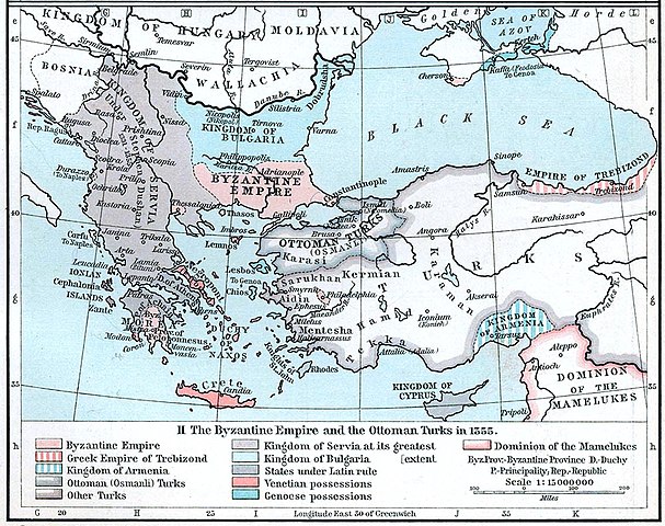
English: Map of the Byzantine, Ottoman and Serbian empires and their neighboring states, 1355. |
||||||||||||||||||||||
| Data | |||||||||||||||||||||||
| Font | William R. Shepherd's Historical Atlas, p. 89, published by Henry Holt and Company, New York 1911 | ||||||||||||||||||||||
| Autor |
|
||||||||||||||||||||||
| Altres versions |
|
||||||||||||||||||||||

Llicència
This work is in the public domain in the United States because it was published (or registered with the U.S. Copyright Office) before January 1, 1929.
Public domain works must be out of copyright in both the United States and in the source country of the work in order to be hosted on the Commons. If the work is not a U.S. work, the file must have an additional copyright tag indicating the copyright status in the source country.
Note: This tag should not be used for sound recordings. |
Historial del fitxer
Cliqueu una data/hora per veure el fitxer tal com era aleshores.
| Data/hora | Miniatura | Dimensions | Usuari/a | Comentari | |
|---|---|---|---|---|---|
| actual | 22:53, 6 des 2022 | | 1.134 × 897 (380 Ko) | Gyalu22 | Artwork |
| 18:44, 29 març 2018 |  | 1.112 × 879 (908 Ko) | Nihil scimus | Few improving (esthetic, contrast, genoese possessions 1355 since Westermann Grosser Atlas zur Weltgeschichte, 1985, ISBN 3-14-100919-8, p. 70, wallachian possessions 1355 under Nicholas Alexander [https://commons.wikimedia.org/wiki/File:Nicolae_Alexandru.jpg] since [https://en.wikipedia.org/wiki/Wallachia#/media/File:Wallachia_13-16c.svg]). | |
| 15:17, 8 nov 2009 |  | 1.134 × 897 (380 Ko) | Alex:D | whitened | |
| 18:00, 3 des 2005 |  | 1.134 × 897 (269 Ko) | Migdejong | Map of the Byzantine Empire in the year 1355. Image comes from the University of Texas at Austin: http://geography.about.com/gi/dynamic/offsite.htm?site=http://www.lib.utexas.edu/maps/historical/history%5Feurope.html Map is released into the public |
Ús del fitxer
Les 4 pàgines següents utilitzen aquest fitxer:
Ús global del fitxer
Utilització d'aquest fitxer en altres wikis:
- Utilització a ar.wikipedia.org
- Utilització a azb.wikipedia.org
- Utilització a az.wikipedia.org
- Utilització a ba.wikipedia.org
- Utilització a bg.wikipedia.org
- Utilització a bs.wikipedia.org
- Utilització a de.wikipedia.org
- Byzantinisches Reich
- Makedonien
- 1355
- Großserbien
- Marino Falier
- Andronikos IV.
- Beylik von Aydın
- Eroberung von Philadelphia
- Eroberung von Gallipoli
- Byzantinisch-genuesischer Krieg (1348–1349)
- Byzantinischer Bürgerkrieg (1352–1357)
- Byzantinischer Bürgerkrieg (1373–1381)
- Kreuzzug von Smyrna
- Benutzer:GerardM/Battles including the Ottoman Empire
- Utilització a el.wikipedia.org
- Utilització a en.wikipedia.org
- Stefan Dušan
- Nemanjić dynasty
- Serbia in the Middle Ages
- Byzantine–Ottoman wars
- Fall of Gallipoli
- Helena Kantakouzene
- Byzantine civil war of 1341–1347
- Byzantine–Genoese War (1348–1349)
- Talk:Kosovo/Archive 27
- Vojihna
- User:GerardM/Battles including the Ottoman Empire
- User:Falcaorib
- Byzantine–Serbian wars
- Utilització a en.wikiversity.org
- Utilització a et.wikipedia.org
Vegeu més usos globals d'aquest fitxer.