
Fitxer:Califate 750.jpg
Mida d'aquesta previsualització: 717 × 600 píxels. Altres resolucions: 287 × 240 píxels | 574 × 480 píxels | 918 × 768 píxels | 1.224 × 1.024 píxels | 1.492 × 1.248 píxels.
Fitxer original (1.492 × 1.248 píxels, mida del fitxer: 494 Ko, tipus MIME: image/jpeg)
| Aquest fitxer i la informació mostrada a continuació provenen del dipòsit multimèdia lliure Wikimedia Commons. |
Resum
| Descripció |
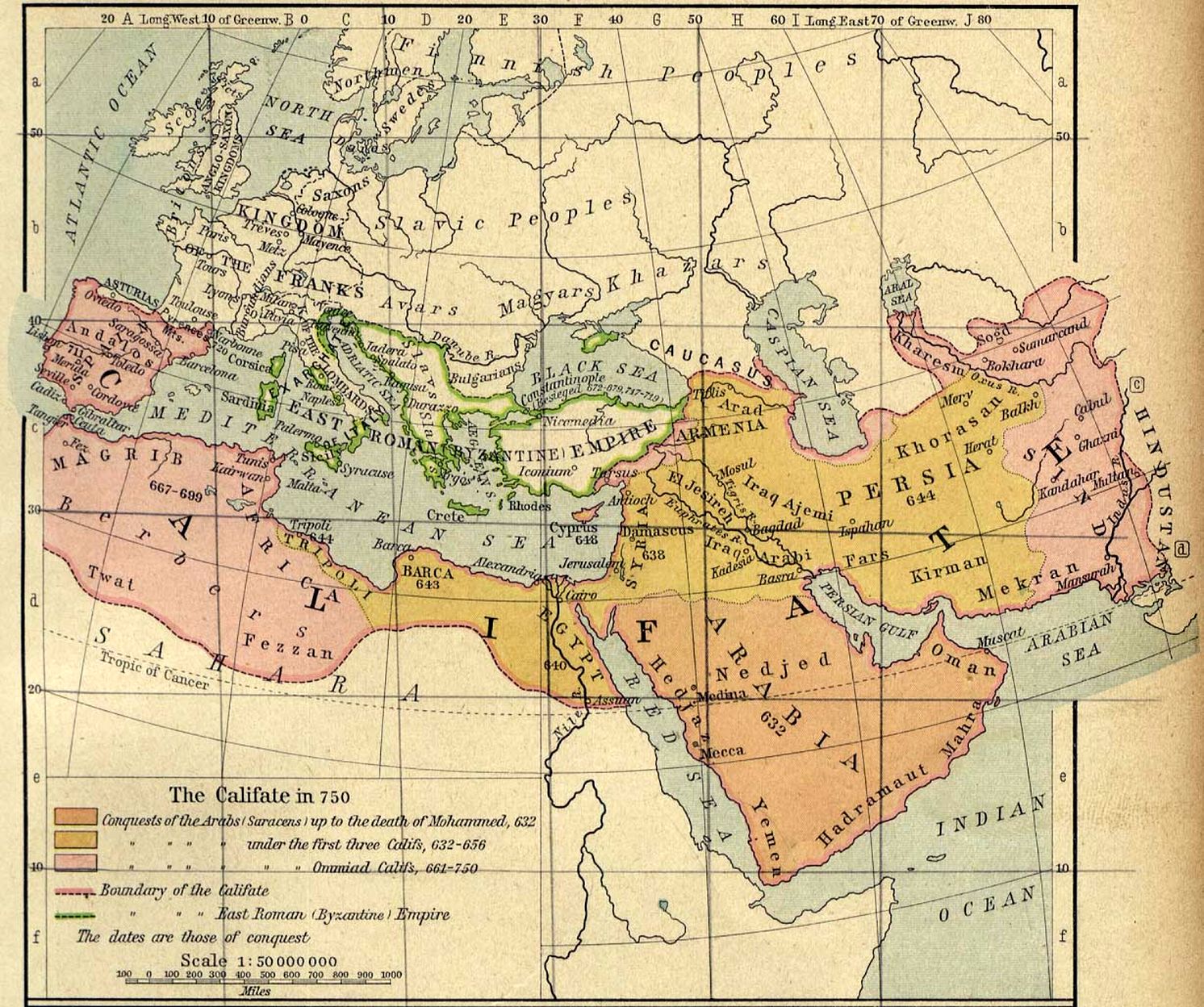
Español: El territorio del Califato en el año 750
English: Map of the Umayyad Caliphate — in 750 CE. |
| Data | |
| Font |
|
| Autor | William R. Shepherd |
| Altres versions |
[]
|


Llicència
This work is in the public domain in the United States because it was published (or registered with the U.S. Copyright Office) before January 1, 1929.
Public domain works must be out of copyright in both the United States and in the source country of the work in order to be hosted on the Commons. If the work is not a U.S. work, the file must have an additional copyright tag indicating the copyright status in the source country.
Note: This tag should not be used for sound recordings. |
Historial del fitxer
Cliqueu una data/hora per veure el fitxer tal com era aleshores.
| Data/hora | Miniatura | Dimensions | Usuari/a | Comentari | |
|---|---|---|---|---|---|
| actual | 22:25, 14 des 2013 | | 1.492 × 1.248 (494 Ko) | Gwillhickers | enlarged image, rendered for brightness and clarity |
| 11:15, 20 abr 2005 |  | 1.229 × 1.028 (293 Ko) | Ben~commonswiki | Middle East and Europe - The Caliphate in 750 (293K) "The Califate in 750." From The Historical Atlas by William R. Shepherd, 1926. taken from http://www.lib.utexas.edu/maps/historical/history_middle_east.html Courtesy of The General Libraries, The Unive |
Ús del fitxer
La pàgina següent utilitza aquest fitxer:
Ús global del fitxer
Utilització d'aquest fitxer en altres wikis:
- Utilització a ar.wikipedia.org
- Utilització a ast.wikipedia.org
- Utilització a azb.wikipedia.org
- Utilització a az.wikipedia.org
- Utilització a ba.wikipedia.org
- Utilització a be.wikipedia.org
- Utilització a bg.wikipedia.org
- Utilització a bn.wikipedia.org
- Utilització a bs.wikipedia.org
- Utilització a ce.wikipedia.org
- Utilització a cs.wikipedia.org
- Utilització a da.wikipedia.org
- Utilització a de.wikipedia.org
- Utilització a en.wikipedia.org
- Utilització a eo.wikipedia.org
- Utilització a es.wikipedia.org
- Utilització a et.wikipedia.org
- Utilització a fi.wikipedia.org
- Utilització a fr.wikipedia.org
- Utilització a gl.wikipedia.org
- Utilització a ha.wikipedia.org
- Utilització a hr.wikipedia.org
- Utilització a hy.wikipedia.org
- Utilització a id.wikipedia.org
- Utilització a it.wikipedia.org
Vegeu més usos globals d'aquest fitxer.