
Fitxer:Elayet of temesvar.png

Mida d'aquesta previsualització: 464 × 599 píxels. Altres resolucions: 186 × 240 píxels | 372 × 480 píxels | 833 × 1.075 píxels.
Fitxer original (833 × 1.075 píxels, mida del fitxer: 123 Ko, tipus MIME: image/png)
| Aquest fitxer i la informació mostrada a continuació provenen del dipòsit multimèdia lliure Wikimedia Commons. |
Resum
| Descripció |
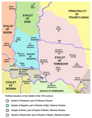
English: historic map of the Eyalet of Temeşvar, Sanjak of Sirem and Sanjak of Segedin
Српски / srpski: историјска мапа Темишварског пашалука, Сремског санџака и Сегединског санџака |
| Data | 28 de desembre de 2006 (original upload date) |
| Font | Treball propi |
| Autor | PANONIAN |
References
- Petrit Imami, Srbi i Albanci kroz vekove, Beograd, 2000.
- The Times History of Europe, Times Books, 2002.
- Istorijski atlas, Zavod za udžbenike i nastavna sredstva - Zavod za kartografiju "Geokarta", Beograd, 1999.
- Milan Tutorov, Banatska rapsodija - istorika Zrenjanina i Banata, Novi Sad, 2001.
- Peter Rokai - Zoltan Đere - Tibor Pal - Aleksandar Kasaš, Istorija Mađara, Beograd, 2002.
- Dr Dušan J. Popović, Srbi u Vojvodini, knjiga 1, Novi Sad, 1990.
- Sima M. Ćirković, Srbi među evropskim narodima, Beograd, 2004.
- Milutin Perović - Relja Novaković, Istorija za III razred gimnazije (opšti tip i društveno-jezički smer) i stručnih škola, Beograd, 1997.
- Milutin Perović - Milo Strugar, Istorija za 7. razred osnovne škole, Beograd - Novi Sad, 1993.
- Sima Ćirković, Istorija za II razred gimnazije prirodno-matematičkog smera, Beograd, 1997.
Source and licence

|
This map has been uploaded by Electionworld from en.wikipedia.org to enable the |
self made map by user:PANONIAN
Llicència
| Jo, el titular del copyright d'aquesta obra, l'allibero al domini públic. Això s'aplica a tot el món. En alguns països això pot no ser legalment possible, en tal cas: Jo faig concessió a tothom del dret d'usar aquesta obra per a qualsevol propòsit, sense cap condició llevat d'aquelles requerides per la llei. |
Historial del fitxer
Cliqueu una data/hora per veure el fitxer tal com era aleshores.
| Data/hora | Miniatura | Dimensions | Usuari/a | Comentari | |
|---|---|---|---|---|---|
| actual | 23:04, 14 set 2013 | | 833 × 1.075 (123 Ko) | PANONIAN | aesthetics |
| 21:40, 5 set 2013 |  | 833 × 1.075 (127 Ko) | PANONIAN | minor changes | |
| 23:02, 22 març 2009 |  | 837 × 1.077 (128 Ko) | PANONIAN | ||
| 20:59, 28 des 2006 |  | 480 × 582 (11 Ko) | Electionworld | {{ew|en|PANONIAN}} historic map of the Eyalet of Temeşvar (self made) {{PD-self}} Category:Maps of the history of Romania Category:Maps of the history of Serbia Category:Maps of the history of Vojvodina |
Ús del fitxer
La pàgina següent utilitza aquest fitxer:
Ús global del fitxer
Utilització d'aquest fitxer en altres wikis:
- Utilització a az.wikipedia.org
- Utilització a bs.wikipedia.org
- Utilització a de.wikipedia.org
- Utilització a el.wikipedia.org
- Utilització a en.wikipedia.org
- Utilització a fi.wikipedia.org
- Utilització a fr.wikipedia.org
- Utilització a gl.wikipedia.org
- Utilització a he.wikipedia.org
- Utilització a hr.wikipedia.org
- Utilització a it.wikipedia.org
- Utilització a ja.wikipedia.org
- Utilització a pt.wikipedia.org
- Utilització a ro.wikipedia.org
- Utilització a ru.wikipedia.org
- Utilització a sh.wikipedia.org
- Utilització a uk.wikipedia.org