
Fitxer:Fladen Light.PNG
No hi ha cap versió amb una resolució més gran.
Fladen_Light.PNG (270 × 312 píxels, mida del fitxer: 112 Ko, tipus MIME: image/png)
| Aquest fitxer i la informació mostrada a continuació provenen del dipòsit multimèdia lliure Wikimedia Commons. |
Resum
| Descripció |
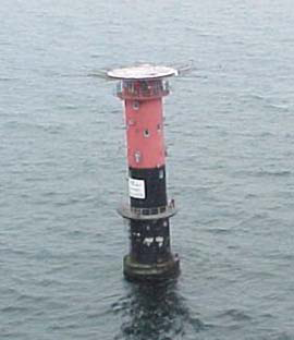
English: Fladen light, (57°13'N., 11°50'E.), equipped with a racon, is shown from a prominent floodlit tower, 26m high, standing on the NE side of Fladen, a sand bank with a least depth of 5.9 meters in teh Kattegat |
| Data | |
| Font | http://www.nga.mil/portal/site/maritime/?epi_menuItemID=eb128c56b8e903e25b2a7fbd3227a759&epi_menuID=35ad5b8aabcefa1a0fc133443927a759&epi_baseMenuID=e106a3b5e50edce1fec24fd73927a759 Sailing Directions Enroute, Vol. 193, page 95 |
| Autor | NGA |
Llicència
This image is a work of the United States National Geospatial-Intelligence Agency or one of its predecessor agencies. As a work of the U.S. federal government, the image is in the public domain.
|
 |
Historial del fitxer
Cliqueu una data/hora per veure el fitxer tal com era aleshores.
| Data/hora | Miniatura | Dimensions | Usuari/a | Comentari | |
|---|---|---|---|---|---|
| actual | 08:27, 13 ago 2009 | | 270 × 312 (112 Ko) | Ratzer | {{Information |Description={{en|1=Fladen light, (57°13'N., 11°50'E.), equipped with a racon, is shown from a prominent floodlit tower, 26m high, standing on the NE side of Fladen, a sand bank with a least depth of 5.9 meters in teh Kattegat}} |Source=ht |
Ús del fitxer
La pàgina següent utilitza aquest fitxer:
Ús global del fitxer
Utilització d'aquest fitxer en altres wikis:
- Utilització a ar.wikipedia.org
- Utilització a bn.wikipedia.org
- Utilització a de.wikipedia.org
- Utilització a en.wikipedia.org
- Utilització a hr.wikipedia.org
- Utilització a la.wikipedia.org
- Utilització a sl.wikipedia.org
- Utilització a sv.wikipedia.org
- Utilització a www.wikidata.org